PHYSICAL CONDITIONS OF VILLAFÁFILA

|
PHYSICAL CONDITIONS OF VILLAFÁFILA |
|
|
|
|
|
|
|
|
|
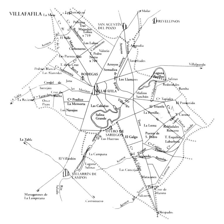
The relief of Villafáfila has been shaped by two rivers: the Salado and the Esla. This one in a small part in the NW of the term Arroyo del Valle, that one in the rest of it. Both have given rise to wide valleys, presenting slightly hilly reliefs, with an average altitude of 700 m. The materials of the Salado river basin are made up of Vindobonian, Miocene and Tertiary clays, which form the Esquilón, Corona, Cruz, Lobos, etc., "tesos" on the edges. That resists erosion. The teso de los Obispados is the one with the highest altitude, with 733 m. It receives this name because the bishoprics of Astorga, León and Zamora previously coincided there. This erosion is so great that it has given rise to pontoons and caves, whose dragged materials have clogged the bottom of the basin. The unevenness caused is so small that it barely reaches half a meter between the town and the river drainage, in the vicinity of Villarrín de Campos. |
|
|
|
The bottom of the basin is made up of slightly alkaline silty clays, from the Holocene Quaternary, coming from previous drags, very impermeable, with abundant sodium, potassium and magnesium salts. These have given rise to endorheic lagoons, lavajos, which form with its belfry and reeds a marshy area, with abundant migratory fauna. There are three lagoons formed: Salina Grande in Villafáfila, Salina de Barrillos, between Villafáfila and Revellinos, and Laguna de Salinas, between Villafáfila and Villarrín.
The materials of the stream valley that conducts the waters to the Esla River are Vindobonian clayey with higher sandy content and small boulders-gravel, chinaco, from the Quaternary Pleistocene, in some parts (La Mata) and therefore less impermeable. Its altitude is higher, about 710 m. we would like to highlight a small Silurian Ordovician Quartzite stain, existing in the vicinity of Tabla el Sierro as it is the stone quarry from which Villafáfila is supplied for the construction of the basement of its buildings. It is already outside the municipal term. The flow of these rivers and their stream is subject to the local pluviometric regime, in such a way that they only flow when it rains. Although in the river, due to its low slope, the water is dammed, giving rise to the aforementioned salt flats, to disappear due to desiccation, when the summer season arrives. The deposited salts, previously considered, rise by capillarity to form whitish crusts on the surface, which have been the object of gunpowder manufacturing in the 18th century. The cultivated soils, in their greatest proportion, are those corresponding to the Loma denomination. They are what corresponds to the interfluves Salado Valderaduey and Salado-Valle to the east and west of the urban nucleus of Villafáfila. The term portion corresponding to the first interfluvium receives the name, as a local toponym. They are soils poor in organic matter, even more so years ago when the stubble was burned abundantly, with low percentages of phosphorus and potassium and an abundance of lime (PH 7-8). Tillage on these soils is difficult, due to their clay content, which makes them very consistent, they retain water very poorly and easily become lumpy. They are called neighborhoods. Only very rainy years within the rain limits that we will indicate, nor very dry. Others, with less clay and easier work, with the so-called love ones, which retain more moisture. Finally, the so-called cascajos or chinacales are looser and are preferably found in the place called "Mata" in the part we call "Valley" Villafáfila also owns fertile plains, in the place of the same name, although these are not exactly like those of the rivers. They are from more compact land, because they are even more clayey. Around the urban nucleus, there were irrigated lands through artesian wells, they have disappeared, due to the failure of these. In them was water to depths of 20-30 m. that rose to the surface on its own. Today you have to drill hundreds of meters to reach it and extract it using hydraulic pumps.
In the vicinity of the salt flats, the land is "brackish", due to the abundance of salts. It is an area without trees, although there is a small spot of poplars in the "Alameda" area. Attempts are made to repopulate with pine trees. Outside the municipality of Villafáfila, on both sides of the east, the patches of holm oaks are dominant: Montes de Castronuevo, La Tabla and Barcial del Barco and somewhat more distant the Raso de Villalpando. As a final, we have to review the grass lands that correspond to uncultivated areas where herbaceous vegetation develops, where it exists. There are three meadows that Villafáfila has: De los Llamares de San Fagúndez and del Valle, which feed, through time, a livestock: horses, sheep and cattle. |
|
|
|
The climate is purely continental, corresponding to an average altitude of 700 m. and the isolation caused by the mountains that separate the plateau from the Galician and Asturian lands: the Galician-Arthuric System. In particular the closest mountains: Teleno, Cabrera and Culebra that prevent the arrival of humid air from the sea. The result of all this is a lack of rainfall, estimated at an annual average of 400-500 liters per m 2 . The rainiest seasons are spring and autumn. The temperatures as a consequence are extreme, characterized by a rigorous winter, which includes no less than five months, a short spring and autumn, and a hot summer, although not too hot. The frosts and fogs of winter are continuous, practically during all of it, reaching temperatures that can be 10-12º below zero. This makes the terrazzo present a high degree of aridity. As for precipitation in the form of snow and hail, it is distributed in the winter and spring months, respectively, with an average frequency of around one day per month. The windiest time corresponds to winter. In this season, the influence of the Azorean regime is manifested by the arrival of cloudiness accompanied by turbulence with a western main component, which can drift southward until coming from a markedly southerly direction. These climatic conditions and soils mean that crops must be resistant to survive. The cereal in its varieties of wheat and barley and the vine are practically unique plants that occur in the area. To these are added, in the few existing irrigated areas, the fodder and industrial plants of alfalfa and beet. The abundant vine has completely disappeared, to the point of having wineries but without wine. |
|
|
Author:
Jose Luis Dominguez Martinez.
Text:
Jose Luis Dominguez Martinez.
Photography:
Jose Luis Dominguez Martinez.
Transcription and montage:
Jose Luis Dominguez Martinez.
All text, photographs, transcription and montage, the rights belong to their authors, any type of use is prohibited without authorization.
All text and photography has been authorized for storage, treatment, work, transcription and assembly to José Luis Domínguez Martínez, its dissemination on villafafila.net, and any other means that is authorized.