OVENS AND HOUSES OF VILLAFÁFILA


![]()
|
|
OVENS AND HOUSES OF VILLAFÁFILA |
|
|
|
||
|
|
||
|
C ovens and booths in the heart of Castilla. From mud to stone in Tierra de Campos and Montes Torozos
PRESENTATION Being February 09, 2013, in Villafáfila, one afternoon that was cloudy, cold, as I was about to have a coffee, when I almost arrived at the establishment, as I do not believe in coincidences, I suppose it was a meeting between people who have certain concerns about the themes of rural architecture, as later he classifies me among his notes. A young couple approaches, he kindly addressed me: good afternoon, I'm Oscar Abril Revuelta , (Architect, infographics, studied ETSAM at the Technical University of Madrid) and my partner Inma who accompanies me (and helped him). I am Jose Luis . Oscar brought a photograph from a book of a booth with a holm oak next to it, it said Villafáfila, which he shows me, he asks me: does this booth exist that I am showing you in Villafáfila? , and I answer: not known to me at all , we asked older residents of the town if they knew about it and they didn't either.
*After eight years and ten months, almost the end of 2021, just about to start publishing the work on my website villafafila.net, a friend of Goyo Cañibano Vicente, sent him the work so that he could read it quickly, and contacted me and told me “ that booth belongs to “Pericote”!” Perico Benayas, the tree a little black, next to it there was a waterwheel, and he gives me its location with good references, which I confirm with my father: LOCATION There was what is now an agricultural plot, almost at the edge of the road that today leads to San Agustín del Pozo (ZA-704), Km 30, in the San Andrés payment, Villafáfila is approx. 600m. Longitude: 41°51'.7"N. Latitude: 5°36'46.7"W. https://goo.gl/maps/6DbXDk7DEsXPAoes6 In the plot concentration map of Villafáfila, polygon 6, plot 530.
Cadastral reference: 49271A001005300000FJ. Location: Polygon 1 Plot 530. SAN ANDRES. VILLAFAFILA (ZAMORA). Rustic Class: Agricultural main use. Graphic area: 8,326 m2.
The tree has disappeared, but remains of the Ferris wheel still remain.
Oscar asks me , are there still booths and ovens in Villafáfila? I answer him: booths yes , behind you there are booths , the stranger hadn't seen anything, he looks at me, looks back again, and answers: he doesn't see anything , just a building that says Fire Department , I answer again: behind what your sight does not see, there is one of the booths . Together we went to the first booth, between us the understanding was quick because our taste for the theme of popular constructions made us have a very kind fluidity, he with his desire to document them and I to help him, in what had been part of the life of the peasants of the Villa, I wanted to have more data and knowledge of them, I remember that in some booths that I had known as a child, I played in them, some in decline and disappearing. Like some oven, of which at that time none existed. It also brought some documentation on classified ovens in Villafáfila, although none existed anymore. So we got down to it, I showed him the booths that were to the west of the town that we had close at hand, between which we were walking, he told me about his work, he explained it to me and he asked me questions, he dated with photographs, measurements, point of place, etc., then we went by car to those in the eastern part of the Villa, some huts were still standing and others in the collapse phase, I approached him to the interlocking of one of the ovens that he had documentation, only certain remains of oven. The afternoon was very prolific for both of us, his census took us a few hours, time was pressing on him and he refused my invitation to have a coffee, walking I told him to go and take a census of a beautiful oven on the road to Vidayanes that he would see from the same road. Oscar let me take a photo of the documented information he brought from Villafáfila. In a few days, I sent him photos that I had in my hand at that time. Later on, I took certain photographs of booths and ovens that I also sent him for his records. In 2014 Oscar sent me the Villafáfila part of the work, as well as the indication of all the work. In 2014 he publishes : April Revolt, Oscar (2014). Huts and booths in the heart of Castilla. From mud to stone in Tierra de Campos and Montes Torozos . Joaquín Díaz Foundation, Urueña (Valladolid). ISBN 978-84-695-9847-4; in which Villafáfila is included, where I extract from it for the explanation and the particularity that we will make this section on Villafáfila's ovens and booths. In 2017 publishes: April Revolt, Oscar (2017). Huts and booths in the center of Castilla y León: from mud to stone in the rural architecture of Tierra de Campos and Montes Torozos . Thesis (Doctoral), ETS Architecture (UPM). https://doi.org/10.20868/UPM.thesis.48841. http://oa.upm.es/48841/51/OSCAR_ABRIL_REVUELTA_ANEXO_01_09.pdf From here I have chosen the part of Villafáfila that is the most up-to-date.
FOREWORD The circumstance of having known, almost simultaneously, from my dear friend Joaquín Díaz and from myself, all the documentation —texts, plans and photography— prior to the definitive drafting of the Doctoral Thesis by the architect Óscar Abril on the huts of pastor still existing in several provinces of the old Gossip, revived the interest of our great Joaquín for something that he has been demanding of me for a long time: that I make known some of the facts related to my decision (and with the audacity to carry out ) of a global study -and complete as far as possible- of the exciting subject that represents the Spanish popular architecture Without me absolutely sharing the "Machadian" affirmation that "the message is the medium", it is quite true that, on this occasion, the medium that will transmit these notes decisively conditions the space in which I have, space that I have already begun to squander with this surely very expendable preamble. Going into the matter, I will try to specify one among the many aspects that could be addressed, that of the difficulties —DIFFICULTIES— to overcome in such an endeavor. And that —to avoid my tendency to weigh the bushes— I will summarize in three sections: A) Limited time available. B) Of an economic nature. C) From "alone in the face of danger". A) The existence of a contract with AGUILAR, SA committing to publish my work in several volumes and the method, in these cases, of marketing it largely through pre-publication subscriptions, meant for me the commitment to respect fixed deadlines for delivery of the original. B) The fact that both the preparation of the work and its definitive writing had to be carried out without any type of economic aid —scholarships, travel grants, advances, etc.— required me to reconsider, for such purposes , rigorous and restrictive. A) With regard to the theme of «loneliness», I must mention two equally important aspects: the first would be related to the almost complete lack of studies on the subject (and even the scarcity of monographs) whose existence would have served as a guide. Here I must mention as a very valuable exception the one carried out, in the first decades of the 20th century, by Don Leopoldo Torres Balbás, my dear and remembered professor at the ES of Architecture in Madrid. The second "loneliness" would be another consequence of the "economic precariousness" of the operation, which did not allow, as would have been desirable, the formation of a multidisciplinary team within which various specialists in historical issues had a voice and contributed their knowledge, geographical, ethnological, socioeconomic, etc., etc., so directly related to the complex field of the popular and its architecture. In any case, and speaking of difficulties, I think that mine are dwarfed if we compare them with those that our great Joaquín Díaz had to overcome, whose «field work» included nothing less than getting half of the old men of Spain to sing for him (and even a large number of Europeans in relation to the extremely important and scarcely studied —and «sung» Sephardic musical folklore). Likewise, and as part of the "cabinet" work, the almost impossible effort to put voice, words, sounds and sensitivity in recording studios, making possible the recovery - the recreation - of a cultural legacy of interest above any consideration . Having clarified all this, I want to record that in the last conversation with my friend JD, he was warned that if he gave in to the temptation of deleting the previous paragraph we would see each other in court. As ending; And returning to the topic with which I started, I would like to record my congratulations to my colleague Óscar Abril, thanking him for his important, intelligent and conscientious work, carried out for his Doctoral Thesis.
Carlos Flores (Doctor Architect)
INDEX 1. INTRODUCTION AND APPROACH TO THE STUDY 2. OBJECTIVES 3. STATE OF THE QUESTION 4. METHODOLOGY 5. THEMATIC BODY 5.1 STUDY OF THE PHYSICAL ENVIRONMENT 5.1.1 GEOGRAPHICAL STUDY 5.1.2 STUDY OF THE NATURAL ENVIRONMENT 5.1.2.1 GEOLOGY 5.1.2.2 TOPOGRAPHY 5.1.2.3 CLIMATOLOGY 5.1.2.4 HYDROGRAPHY AND VEGETATION 5.1.3 STUDY OF THE POPULATION 5.1.3.1 DEMOGRAPHICS 5.1.3.2 ECONOMY 5.2 CASE STUDY 5.2.1 TYPOLOGICAL STUDY 5.2.1.1 EVOLUTION OF THE PREDOMINANT MATERIAL 5.2.1.2 COMPOSITION: FLOOR AND ROOF 5.2.1.3 GROUPS 5.2.1.4 GLOBAL SCHEME AND PARTIAL CONCLUSIONS 5.2.2 CONSTRUCTION STUDY 5.2.2.1 MATERIALS 5.2.2.2 SYSTEMS AND CONSTRUCTION TECHNIQUES 5.2.2.3 STRUCTURAL BALANCE 5.2.2.4 OTHER ELEMENTS 5.2.3 OTHER STUDIES 5.2.3.2 STONE-EARTH INFLUENCES IN CAMPOS AND TOROZOS 5.2.3.3 PATHOLOGICAL STUDY 5.2.3.1 FUNCTIONAL STUDY. THE USE OF BUILDINGS 5.2.3.4 BIOCLIMATIC BEHAVIOR 5.2.3.5 PHYSICAL CHEMICAL STUDY 6. CONCLUSIONS 7. GLOSSARY 8. BIBLIOGRAPHY AND SOURCES OF INFORMATION ANNEX 1 - CATALOG OF BUILDINGS IN «CAMPOS Y TOROZOS SHEETS ON MUNICIPALITIES, CHARACTERISTICS OF SAMPLES AND GRAPHIC DESCRIPTION OF SOME OF THEM 95 (1 – Annex 1) ANNEX 3 - SUPPLEMENTARY DOCUMENTATION 270 (1 - Annex 3)
“SHUTS AND HOUSES THE HEART OF CASTILLA FROM MUD TO STONE IN THE LAND OF CAMPOS AND MONTES TOROZOS” Through this research work, we will approach the study of a specific way of building originated through the imagination of local teachers from rural areas in Castilla y León and who, far from the erudite education of architecture, have arranged, so wisely, the materials that are most at hand, to extol the result of their work to a work of art in the numerous cases that we will examine. The Tierra de Campos region, dominated by mud, and the Montes Torozos region, full of limestone, offer numerous examples of constructions built in a humble way but that have been integrated into the landscape as a hallmark of the place and, despite of their different construction styles that we can see a priori, the relationship between the two is progressive and more powerful than one could imagine. In this natural space, furthermore, we find ourselves with a common problem of loss of the building traditions of rural architecture: almost nothing is built with popular techniques anymore and what exists is not used and, therefore, is not preserved and starts to disappear Given this situation, the intention of this work is to classify, describe and, ultimately, record an abandoned architecture that is close to extinction. In this way we will try to discover the links of these constructions to the natural environment that surrounds them and understand the way in which they were built until we identify the values that make these elements be considered as part of the rural heritage. Through the in situ study of these works, a catalog will be developed that describes the unique characteristics of each one of them and reflects the state in which it is found and, in addition, leave a graphic testimony of this humble way of building. Finally, the development of a study method for the reconstruction proposal of one of these examples will provide the keys for the recovery of this rural architecture, as a practical way to solve the localized problem9.
Introduction and approach to the study
Huts and booths. auxiliary constructions Castilla y León sits in Spanish territory as an extensive area surrounded by mountains, generating the traditional image of the interior formed mainly by rural environments where its architecture expresses the sobriety and character of its inhabitants. Many of them, forced to develop their working lives with agriculture and livestock have given as a reply to their economic activity the creation of humble elements but effectively settled in the landscape that contemplates them. We are specifically talking about auxiliary, secondary or complementary constructions, depending on how various authors conceive it, but all of them agree that it is an architecture that manifests itself as a response of the human being to his vital needs. They are defined by this name of "auxiliary or secondary constructions" because within what is popular architecture the building of the house has always been assigned as the main one, the one inhabited by man, and these others have been relegated to a second order, not in terms of importance, but functional classification. In any case, what we are sure of is that these are great works that have remained silent in history until recently and that, in many cases, remain hidden without showing their true dimension. The fact of not having been the object of deep approaches from the field of research encourages us to develop a work of constructive and typological analysis, which serves as a testimony of a peculiar way of doing architecture, and thus face a double problem. that is continuously detected and that little by little is getting bigger: on the one hand we are talking about the loss of these small constructions due to the deterioration caused by the environment that so crushes the materials with which it is built, especially mud;[1] », because the new techniques and new materials are also occupying the non-urban space before the nostalgic gaze of the inhabitants of these areas who for years were able to soberly carry out their own constructions, recognizing the conditioning factors that affect these architectures and developing the techniques inherited from the construction tradition. Together with the detection of these problems, the surprising variety of huts or booths of the era that have been observed by the author, before starting this work, from the point of view of the materials used, the formal composition of the element as a whole or covering systems, motivated the choice of this topic to launch a research task.
country architecture Although most authors have used the term "popular" to define this type of architectural examples, in our study we prefer to use the word "rural" [2] , also used by many others, and which will serve to limit the study of these constructions located outside the large urban environments and whose use is exclusively intended for agricultural life. However, since the great experts who have studied and analyzed this type of unique examples have used the expression «popular architecture» and since we will rely on them to develop different processes in this work, we will also gladly accept this word and use it together to that of rural architecture. We should not ignore other terms such as vernacular architecture or traditional architecture. Perhaps one of the people who has best differentiated these concepts is Javier de Cárdenas [3] who defines the vernacular as that linked to the socioeconomic, historical and geographical characteristics that occur in a certain place; to the traditional one / like that carried out without industrial methods or minimal industrialization, such as brick construction in a region; already the popularlike the one made with the modest materials that the place provides and made with very humble and elementary techniques and tools. So that popular and traditional architecture tend to be, almost always, vernacular, without this always being the other way around. Other denominations [4] are «anonymous architecture», «architecture without architects», «common sense architecture», «performance architecture» or «domestic architecture». In our case and seeking the definition of this way of building that we seek to analyze, it is necessary first to highlight two fundamental aspects: first, that despite being an architecture not carried out by professionals for the exercise of design and planning, it is fair to declare it as a cultured and technical architecture [5] since it is necessary to have a deep knowledge of the material used and its possibilities and the characteristics of the physical environment where they are based, and secondly, that, despite the fact that treaties and guidelines have been made on how to should make such constructions by great authors, here we find ourselves before a profoundly oral architecture [6], since the techniques used have been transmitted from parents to children or from teachers to apprentices both with their virtues, which are many, and with their, fewer and fewer, errors; in contrast to erudite architecture that moves more from the perspective of written knowledge. Thus, with all this we can call rural architecture that carried out in a modest way, in spaces far from urban life and attending mainly to three factors: the first is the climate, since it will influence the decisions to create the different spaces, orientations, coverings, ...; the second is the nature of the land, since it is what will provide us with the raw material to build; and finally there are the sensations and intentions of the human being, as a way of representing their aesthetic concept or their beliefs or traditions of their culture. That said, there are fundamentally two building typologies within rural architecture: residential, which can be presented through grouped examples, these being more limited in terms of their variety and number, or as individual elements, providing greater formal diversity; and secondary or auxiliary constructions (dovecotes, farmhouses, huts, warehouses, mills), those buildings created for the development of the working life of the peasant. The study of the present work will focus on these last constructions, more specifically on the huts and booths [7] . These small buildings appear isolated and, on occasion, combined, in the fields, lands and eras. Its function was to store the farming implements and provide a shelter for the farmer or shepherd to take shelter from the sun or the rain if necessary and, on occasion, it served as a lookout post for the harvest or livestock, even to guard some animal. In other situations we also see them shelter a well and accompany a fountain or a trough. Land of Campos and Montes Torozos: from mud to stone On the other hand, the study does not focus on a specific territory that is very well defined due to its spatial characteristics, but instead covers the analysis of two areas, Montes Torozos and Tierra de Campos, which, due to their great differences in terms of the physical environment, should give us very different constructive answers, however, we believe that there is a series of elements that make us think that between both areas there have been important influences when it comes to building, which has allowed both traditions to benefit technically and enrich themselves artistically. In addition, the existing polarity between two very different and very characteristic materials for each of these two regions does not occur in an absolute way, but there is a degradation of mixed architecture, stone and mud, located on the border strip between the two, worthy of study and whose transition can give us an evolutionary classification. Since from this point of view there have been no observations or studies, at least published, by researchers of some relevance on these issues, we believe that this work can fill a gap in the knowledge of the popular architecture of Castilla y León, which generates an extra motivation for its development.
goals Through the study we propose, we set ourselves two types of objectives: theoretical and practical. The former, described below, are resolved through the analysis of the thematic body. Identify the values that make these constructions unique and special elements to consider them as architectural works of rural heritage and thus justify initiatives for their conservation. Demonstrate through formal and constructive study that these constructions are interesting examples of an architecture that reflects man's response to his vital needs. Indicate the relationship that exists between these examples and the physical environment that surrounds them, in terms of the different construction strategies (materials, structure, typology, orientation, openings...) that can be detected. Describe the construction techniques that human beings have used or have been able to use for the elaboration of these small buildings. Identify the causes and damages by which these constructions have disappeared or have led to a dilapidated state, in order to indicate the way to conserve with the still existing examples. Understand and approach future studies the relationship and influences between the buildings that exist between two areas of nature as different as Tierra de Campos and Montes Torozos. The practical objectives consist of: Prepare a catalog of the samples analyzed in situ, and also of those observed by other authors to fill an existing gap in the knowledge of this type of popular architecture of «Campos y Torozos» [8] and that as an inventory serves to expose a series of buildings that should receive protection to prevent their disappearance. Development of the analytical documentation that serves for the proposal of reconstruction and rehabilitation of one of the analyzed samples.
state of affairs The work we are dealing with encompasses several fields of research. On the one hand, there is the thematic field of popular architecture, of which in Spain we find a large number of authors who have dealt with it both nationally and regionally. On the other hand, there is the study of the physical environment, that is, the study of the place from a perspective related to rural environments and the surrounding landscape, in this case we focus on the space that exists between two regions of the community autonomous community of Castilla y León: Tierra de Campos and Montes Torozos, which occupy up to four provinces (mainly Valladolid, a large part of Zamora and small areas of León and Palencia). Finally we find, narrowing down the subject,which includes the analysis of the constructions related to the life of the peasant who are the ones of interest for this work called huts and huts of the era, and centered on the chosen area. It should be noted that the process of approaching the study center is inversely proportional to the quantity and quality of levels of research found, the closer we get to the core of the work, that is, to the external auxiliary constructions of the population centers, the less information of relevance we have. It should also be noted that the existing documentation on these types of constructions is not very recent, so an update of it seems necessary. Perhaps one of the most complete works of Spanish popular architecture can be found in Carlos Flores [9]in the seventies, where the description of the towns and their constructions give us a great vision of the most interesting constructive characteristics of these examples made by anonymous. In addition, he provides us with a list of the features that define the main concepts of popular architecture with a very exquisite didactic degree, making him the most relevant author for other scholars of this subject. In his work he is able to identify the common features that appear in different municipalities to organize the study areas based on them, thus, for example, he describes the mud villages of the Tierra de Campos area as those where the adobe and the rammed earth They take over all the buildings. This author together with Luis Feduchi [10] , who, at the same time, carries out a similar work but organized by towns visited in his itineraries of Spanish popular architecture, already show us photographs and descriptions where the typical construction processes and techniques of booths are explained. of threshing floors and huts in the regions covered by this work, which, although brief, are of great graphic value, since the sobriety with which they were executed can be seen in them.
Leopoldo Torres Balbás [11] , long before, had already fought to open the way to the knowledge of popular architecture and unknown monuments, through trips through unknown places in the Spanish geography. The development of sketches of the buildings that he observed on the trips made is interesting, drawing all kinds of elements such as the distribution of floors or architectural details such as openings, moldings..., all complemented with a great notion of the existing bibliography, and thus his method of study has served for many later authors. Although we can also say that it was in 1922 where we find the first general Spanish text that refers to this way of building in Spanish Civil Architecture from the 1st to the 18th centuries written by Vicente Lampérez y Romera , where he dedicates a chapter to what he calls "rustic architecture". In the current scenario we have to mention that one of the people who has produced a great work on popular architecture not only at a global level in terms of territory, but from more limited perspectives on specific areas is José Luis García Grinda [12 ], where in addition to developing a detailed study system explaining the fieldwork and carefully examining the most important features of the territory where the popular constructions are located, it is interested in finding the keys to conserving those that can be understood as part of the rural heritage. . Together with Grinda, another of the contemporary authors with exemplary works and with a way of analyzing and cataloging popular constructions through data collection sheets, analysis of the environment, the state of conservation and other relevant aspects to complete the study, he is Luis Maldonado Ramos [13] with works in various regions of Spain.
On the other hand, it should be noted that the link between popular architecture and the land to which it belongs is decisive, since the material with which such constructions are made, the traditional building systems implicit in the customs of each locality, and the climate and other environmental aspects will determine and justify the way in which it is built in each territory. About the two regions that are addressed for the location of this type of architecture, the person who has best explained the characteristics of this territorial strip is Justo González Garrí do who in the 40s, a time when these constructions surely had great functional activity, makes a very complete description of the physical environment, the climate, the population and even the economy of Tierra de Campos[14] and Montes Torozos [15] , indicating the limits of these regions, illustrating their landscape, their monuments and, in some cases, small constructions of popular architecture. Thanks to this great documentation it is possible to find a powerful connection between architecture and territory. In a more limited vision we find people who have specified the study in this way of building with the regions of the Castilian-Leonese community. Thus, Juan Carlos Ponga Mayo and Mª Araceli Rodríguez carry out a global review in Popular architecture in the regions of Castilla y León (2000), where they start from the studies and principles of Carlos Flores specifying the characteristics of the Castilian-Leonese natural regions through examples updated in each of them. The investigation carried out by these authors on the obtaining of the materials that intervene in the auxiliary constructions is important. Much earlier, Juan Mojo Carrió already developed a very technical work in The systems and construction details in the Castilian popular building (1983), in which he compiles and describes very important information on the way in which the popular architect builds in this autonomous community. . It is a work with a large graphic documentation of the most common construction elements and an in-depth written description of the origin, extraction method and execution of the materials used in these buildings. Shortly afterwards, Antonio Sánchez del Barrio [16] delimits the geographical framework to a further extent, explaining the most outstanding constructions of popular architecture in Valladolid, describing the main materials and classifying them by zones, and indicating the construction types based on their usefulness: houses, dovecotes, apiaries, huts, cellars, threshing-floor booths, ... In addition, it summarizes the principles of rural architecture in Valladolid in four from the twenty-four characteristic points formulated by Carlos Flores, organizing them into the following determining factors: prevailing climate in the area, the materials of the place and their traditional handling and elaboration, the surly heritage and the aesthetic concept of its inhabitants and, finally, the beliefs and traditions rooted in the area. Regarding the materials that intervene in popular architecture in the two studied regions, it should be noted that studies on clay (mainly) and stone are a good complement for the understanding of these constructions. In The Architecture of Clay, by Alonso Pon a from 1989, a good work of compilation of the main construction techniques of this material (adobe and rammed earth) is elaborated [17].explained in detail through examples located in Castilla y León, especially in Tierra de Campos, and on which he explains the functionality and way of building the most common types of popular architecture, in a similar way to what Sánchez del Barrio did shortly before. But surely the most profound contemporary work on clay in popular architecture in Valladolid can be found in Mariano Olcese Segarra in his thesis Architecture of Earth: Tapial and Adobe, published in 1993, where he carries out a deep analysis of the great authors who have approached the study of clay in construction, from Vitrubio, Palladio or Villanueva to Torres Balbás. On stone in popular architecture, Juan Manuel Báez Mezquita [18] specifies its different types and the most common techniques that are developed in Castilla y León, indicating the places from which it can be extracted and the causes that condition the way in which it is used. this material. We can find certain works of popular architecture in Tierra de Campos and Montes Torozos separately, such as the one carried out by Fernández Flórez [19] on clay in the first region, compiling information from other authors and adding the aspects found according to the analysis of different constructions, or those developed by Jiménez Arqués [20] in the second, describing constructions in two regions (we do not know if with previous intention or as a result of later reflections, although surely because both belong to the province of Valladolid) for the analysis of examples of popular architecture linked to agrarian life we find the works of Carlos Carricajo Carbajo [21], who has carried out a very significant field work on many popular constructions in the area that occupies our work. The graphic and written description of these samples and the spaces that surround them represent a powerful complement for the development of current research, serving as a starting point for more complete studies. One of the most important reference works on popular constructions in these regions is the thesis Palomares de barro de Tierra de Campos (1983) by Roldán Morales where it represents an exquisite typological classification of these wonderful examples built with earth, describing in a very detailed graphic way all the examples found in an intense field work. This represents “one of the most referenced research works by future authors interested in similar topics. Two other good examples of studies of traditional architecture, although they are not based on our region nor are they similar constructions, are the thesis on Constructive reason for black architecture in Guadalajara (1991) by Luis Maldonado Ramos and Bombos de Tomelloso: the dome as a dwelling (2004) by Bernalte Patón, where the work methodology based on the analysis of the place and the constructions found, apart from being more modern than that of Roldán Morales,[22] of the year 1986 classifying and characterizing the popular constructions of its study space.
Evidently there are many more authors who have dealt with some of these fields of exploration that will also serve to follow up this work and that are listed in the general bibliography. we find the CIAT (Traditional Architecture Interpretation Center) based in Boceguillas (Segovia) and directed by Luis Maldonado Ramos and Fernando Vela Cossío. It was created in 1996 and is intended to carry out activities in research, training, dissemination and protection of traditional architecture. We can say that the state of the question has been examined from very general fields and from different points of view, which has allowed us to understand and establish the way in which the constructions that we deal with for this work should be studied, since all of them, However disparate they may be, they present an analysis based on a common pattern. On the other hand, it has also been possible to establish and understand to what extent there is research on the topics that we propose and we have realized that there is no extensive and precise documentation on the delimited place and especially on the perspective that is raised and therefore The intentions of this work are born, in part, to cover a certain lack of knowledge in the investigation of auxiliary agricultural constructions in these two Castilian-Leonese regions.
Methodology Next, all the processes that have been carried out to be able to analyze the architecture of the rural constructions that cover the proposed study area will be explained. In addition, this work system will serve us to complete two of the main purposes that we have set as a goal: the graphic and descriptive catalog of the auxiliary buildings of Campos and Torozos, and the proposal for the reconstruction of one of them. Therefore, a global and common methodology is proposed for the advancement of these two phases of work. It has been possible to analyze the methodological developments of great authors who have investigated constructions of popular architecture. All of them coincide in various aspects: a good command of the bibliographical references, an orderly field work and a characterization of the analyzed samples. Thus, we highlight the following levels of work: The first level corresponds to the theoretical framework through the documentary search compiling an extensive bibliography. This will help us to explain the state of the matter (which is included in the previous point) and will also help us to observe examples and samples that other authors have analyzed, especially those found in the study area that occupies in our work. The search is carried out from a The search is carried out from a central scale (Madrid), passing through a provincial one (Valladolid) and reaching a local one (information centers in different localities).
MADRID Library of the Higher Technical School of Architecture - UPM Library of the University School of Technical Architecture - UPM Library of the University School of Agricultural Technical Engineering - UPM COAM Library National Library VALLADOLID Archive of the Royal Chancery General Archive of Simancas Library of the Faculty of Philosophy and Letters - UVA Library of the Higher Technical School of Architecture - UVA Deposito Campus Delibes COACyLE Library LOCAL AREAS Library of the Joaquín Díaz Ethnographic Center (Urueña) Urueña City Council — Tourist Office Shepherd Museum (Montelagre de Campos) Agricultural Museum (Autilla del Pino) Shepherd Museum (Montelagre de Campos) Agricultural Museum (Autilla del Pino) The result of this search is summarized in the following bibliographical references, in which it has been possible to find information on the constructions that are specified (such as those in Illustration 5 on the next page) and which have later been observed in situ or has been able to collect information about them through testimonials descriptive enough to take them into account: Mayor Crespo, Gonzalo. 1989. Palencia, Clay, Wood, Stone . Photographic information, and detailed description of huts and booths. Analysis of the natural environment. Alonso Ponga, Jose Luis. 1989. The Architecture of Clay . Photographic information, drawings and details of elements of agricultural constructions in Zamora, León and Valladolid. Benito Martin, Felix and Hiernaux Gonzalez, Jose Luis. 1998. The Traditional Architecture of Castilla y León . Illustrations and written description of hut in local Caro Baroja, Julio, Cea Gutiérrez, Antonio, Fernández Montes, Matilde and Sánchez Gómez Luis Ángel. 1990. Popular Architecture in Spain . Photographs and comments on farmhouse in Valderas (León). Carricajo Carbajo, Carlos. 2010. 50+1 Vernacular Constructions In The Province Of Valladolid . Detailed description with comments, dimensioned drawings, construction details and photographic report of several rural constructions in Valladolid. Carricajo Carbajo, Carlos. 1995. Secondary Constructions . Limited graphic documentation and explanations of examples of popular architecture. Corral Castanedo, Antonio Diez, Justino 1999. The Montes De Torozos (Approaches to a Region). Valladolid: Box Spain . Photograph of a hut in Castromonte (Valladolid). Delibes Miguel. 1980. Castilla, Lo Castellano v Los Castellanos . Image of a hut and booth in Urueña (Valladolid).
Feduchi Luis. 1974. Itineraries of Popular Spanish Architecture. J, The Northern Plateau . Extensive graphic and written documentation accompanied by images of examples from various locations in the study area. Fernández Flórez, Mª C. and Fernández López, E. 2000. The Clay in Tierra De Campos . Drawings of auxiliary constructions. Flowers, Carlos. 1978. Spanish Popular Architecture . Extensive graphic and written information accompanied by photographs of samples from various municipalities in the study area. Joaquin Diaz Foundation. «Collection of Photographs of Castilla y León. People Monument . Archive photographs of huts and booths in Urueña (Valladolid). Garcia Grinda Jose Luis. 1991. Leonese Popular Architecture . Graphic and written description of agrarian booths in the province of León. García Grinda, José Luis, Nieto González, José Ramón and González Fraile, Eduardo. 2007. Architectural Heritage of Castilla y León . Photographs and comments about buildings in the study area. Gonzalez Garrido, Justo. 1941, The Land of Fields: Natural Region . image huts in Tordehumos (Valladolid) in the middle of the 20th century. Olcese Segarra. Mariano. 1993. Earthen Architectures: Tapial v Adobe . Photographic report, graphic description with construction details and structural diagrams of huts and booths in the province of Valladolid. Pahíno, Luis, Jové, Félix, Muñoz de la Calle, David and Díaz-Pinés Mateo, Fernando 2011 Reconstruction Works of the Old Miraflores Chozo in Tordehumos, Valladolid, Recovery of the Vernacular Heritage . Images and bounded drawings of stone hut. Ponqa Mayo, Juan Carlos and Rodríguez Rodríguez, María Araceli. 2000. Popular Architecture in the Regions of Castilla y León . Illustrations of rural buildings in the study area. Ricardo Bridge 1997. Urueña: Balcony of Tierra de Campos . 1993 photograph of hut. Big ditches. Ferdinand. 2009. “More is less”. Build in mud. An architecture of the future . images and comments of several examples of rural architecture in the Castilian area. Roldan Morales Francisco Pedro. 1996. Popular Architecture of the Province of Valladolid . Graphic documentation with bounded and written drawings of numerous agricultural constructions. Sanchez del Barrio, Antonio. 1987. The Popular Constructions . Image and drawing of a hut in Ceínos de Campos (Valladolid). At the second level we talk about field work. From a knowledge of the territory and the location of the municipalities where the constructions that we have detected through other authors are located and that we are going to try to analyze, «systematic raids» will be carried out [23] , since it is impossible to analyze the area at one hundred by one hundred. Establishing a central point in the entire study area, fixed in the town of Urueña, since it is located on the border that separates Tierra de Campos from Montes Torozos, itineraries are programmed based on the distances to be covered and the hours of sunshine. that the day has, leaving ample room for possible unforeseen stops, if, for example, examples of this architecture are discovered that no one has yet described. In the first place, a list of the towns that we are going to visit will be made through the consulted bibliographic citations, which will later be expanded thanks to the towns cited by the people that we can interview, and also with the unexpected cases that we find during the development of the visits. The following table shows the 49 municipalities that have been incorporated into the study, of which 34 already appear in the references of other authors, five of them were visited on the recommendation of people interviewed by the other towns (these are preceded by a dot in the list below) and another five were discovered by surprise while tracing the routes (preceded by a hyphen) [24] . Only in six of them we did not find any construction or the ones we expected to find were missing (in gray). Other municipalities have also been incorporated into the table that, although they do not belong to the studied area, contain similar constructions that other authors have examined (in maroon color) and that may be useful for certain analyses.
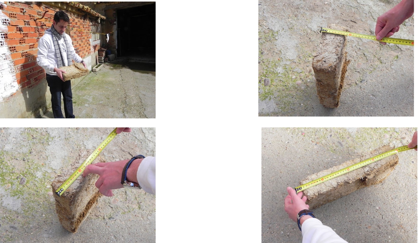
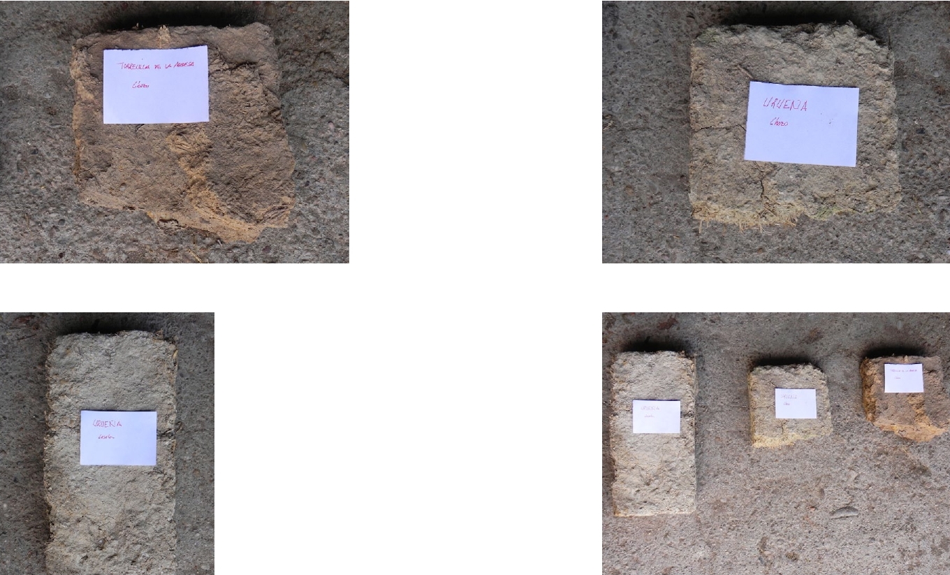
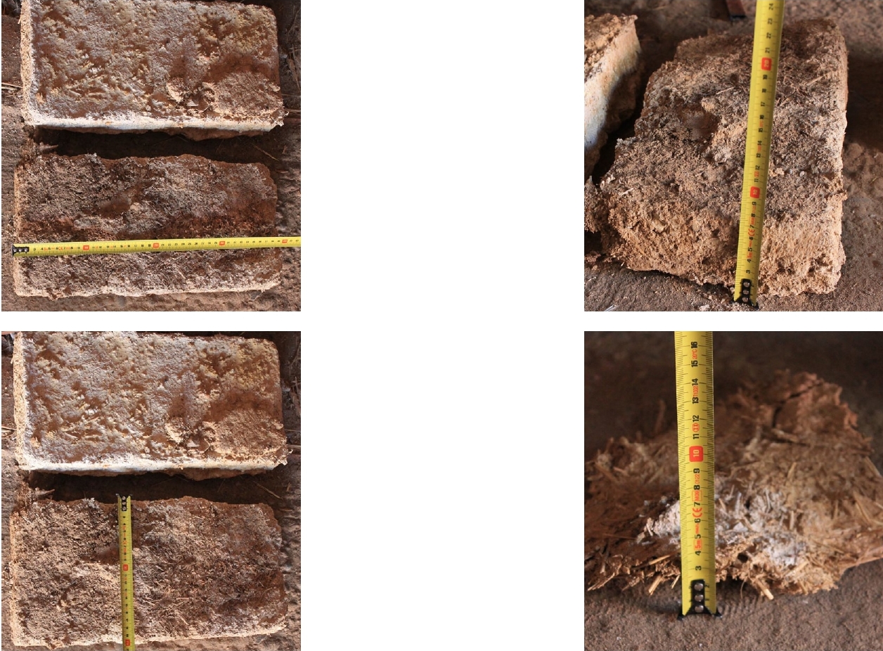
Next, a map is drawn up where the routes to be carried out are marked and the location of the municipalities where the buildings we are dealing with are located and the number of samples that exist in each one of them. Later (in the analysis of the thematic body) we will use these location points on a geological map, since in this way we relate the sample to the type of soil from which the material for its construction is obtained. The scheduled routes are as follows (see together with illustration 7): Tour 3 (blue) . Southwest area of Tierra de Campos Villanueva de los Caballeros — Bustillo del Oro — Villafáfila — Vidayanes — Valdescorriel — Calderas — Prado — Castroverde de Campos — Barcial de la Loma — Villafrechós — Morales de Campos). One of the main clay itineraries finding the good use of rammed earth and adobe on these architectures. Prior to the visits to these municipalities, a data collection form is drawn up that will be filled out for each construction. These will be the basis for future cataloging files of the cases studied and, although in a simpler way, they should include the following points [25] Location , by means of a small map of the municipal term and another of the population center to be able to locate the sample with respect to the municipality, and if possible, the places from which the material with which the analyzed samples are constructed is extracted, such as areas near the river for the elaboration of adobes. Description of the environment , pointing out geomorphological, microclimatic, hydrological characteristics, indicating the presence of watercourses, fountains, vegetation that may influence the building, as well as its location with respect to the plot and orientation, its exploitation and the possible presence of other constructions or elements of interest in it. Bibliographic References , thanks to which we have launched ourselves to study the samples, and that will help us to ask the inhabitants of these places about them, supporting us with the inclusion of photographs and/or drawings of them. Graphic description of the object , where the orientation, size and shape of the plan and elevation, the accesses and openings of the enclosure can be described, and with a simple volumetric profile for the visual understanding of the notes taken, if necessary. Certain exterior elements related to the construction, such as shade trees, fountains, wells or cisterns, will be noted down, as well as a description of the interior space, pointing out characteristic elements such as benches, mangers or cots. All this by means of sketches and accompanied by dimensions taken with a meter or laser meter. Materials and construction techniques indicating the materials used, the structural system of walls and roof and form of settlement to the ground, provision of auxiliary architectural elements such as landings or lintels and treatment received by the interior and exterior walls. Anthropological aspects to explain the habitat, if it has been temporary or permanent, define the number of people who use or used it and the activity for which they were built, including indicating the possible tools or machines that were kept, or the number and type of animals who occupy it, management of the farm: owned, leased... Through interviews with nearby inhabitants, if possible, older people who, due to their experience, can reveal important data, or also the owners of the same samples , we can get this information. In Other observations , additional information can be expanded and aspects such as the current state of conservation can be indicated. Data of the person interviewed , to give veracity of the testimonies that have served us to improve the understanding of the elements studied, indicating name and surnames and link to the observed sample. The work will be completed with an extensive photographic report, with snapshots that collect as much information as possible and from points of view that make its volumetric understanding better.
Below is a data collection sheet for one of the analyzed examples:
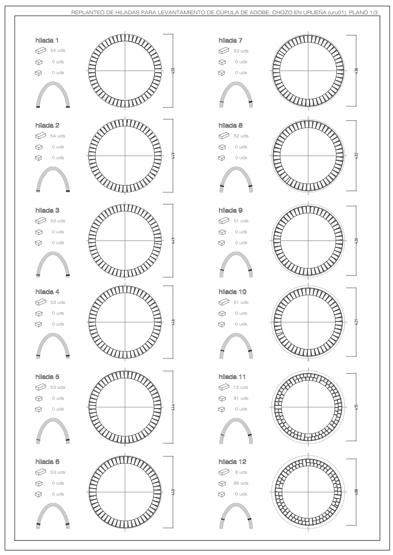
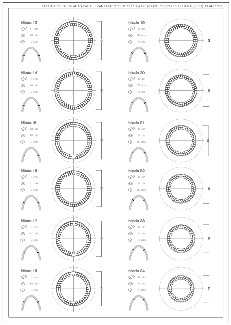
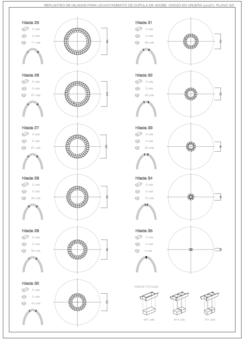
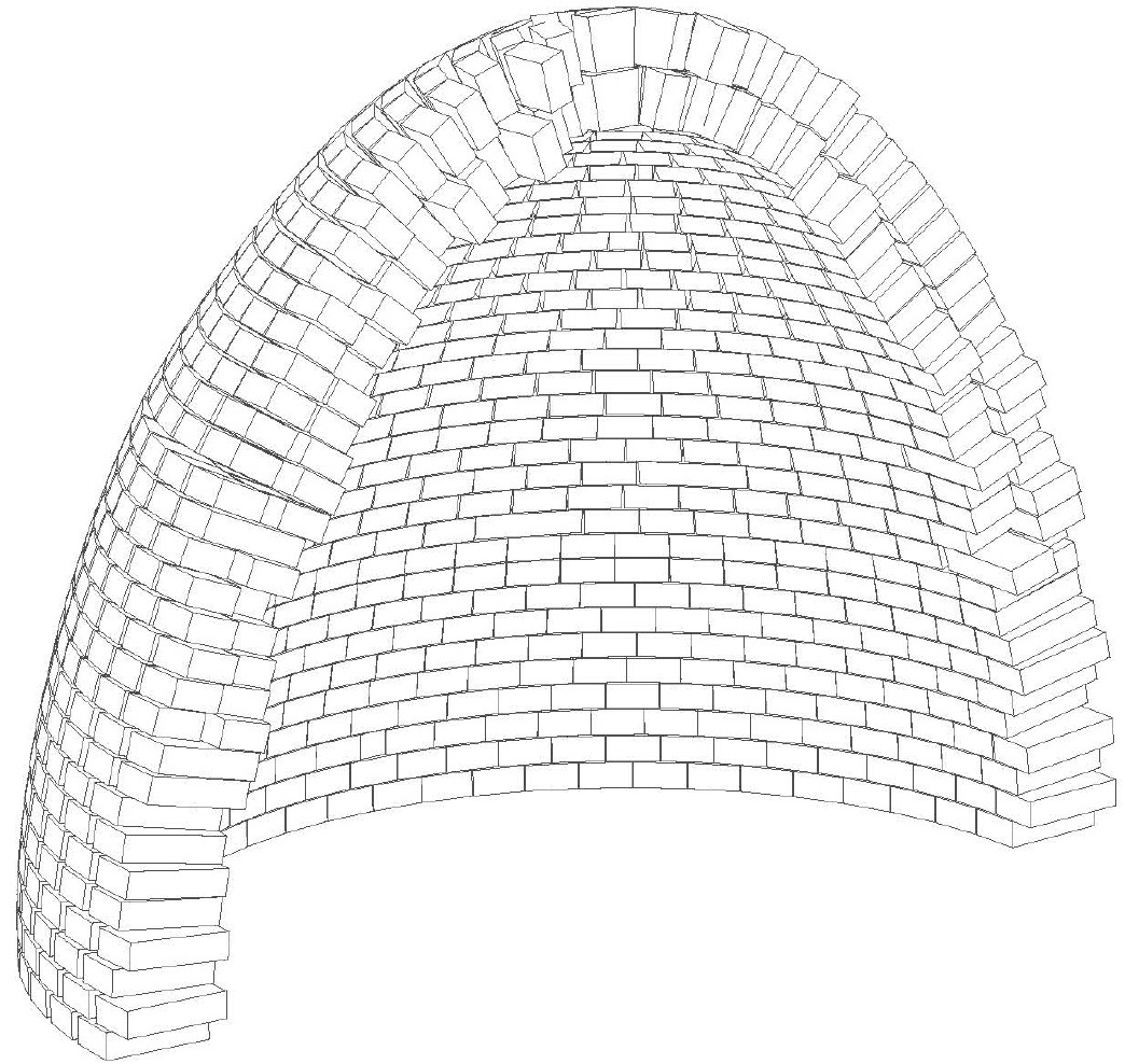
Once we have inspected all the samples, the analysis of the thematic body that occupies this work will be carried out. In this, a study of the geographical framework will be carried out from the geological, topographical and climatological characteristics, through maps and cartographies, to the analysis of the population through tables and graphs; and the actual study of the samples that entails the typological analysis, the constructive analysis and that of other architectural aspects that intervene in this popular architecture through tables, graphs, drawings, three-dimensional models or other tools that allow a better reading. What is sought in this section is to make a complete classification that identifies the main characteristics of this way of building. Both for the development of these analyzes and for the preparation of the catalog (Annex 1), some characterization sheets must be made for each sample that help guarantee the objectivity of the work. These tabs, similar to, but more organized than those for data collection and with the intention of being able to classify them, are organized as follows: Sheet 1 . Municipality. It includes the location data (province, region, judicial district to which it belongs, distance to the capital of the province, latitude, longitude and altitude coordinates, area of the municipal term and number of inhabitants) accompanied by the location plans or maps of the locality (territorial, geological and administrative) and the location of the sample(s), together with a brief description of the place and what was found there. It is given a three-letter code accompanied by the initial of the province to which it belongs. Sheet 2 1. Sample analysis. The general data of the sample is described (denomination or name that it receives, street or plot where it is located, surfaces of the plot and of the sample, orientations, owner, year of construction and activity) accompanied by a map of the situation with respect to the plot to which it belongs. The corresponding boxes that can classify the sample in terms of the different types detected and their construction and structural system will be marked, and their state of conservation will be established. The observation fields will include those peculiar elements that cannot be defined in the characterization boxes, such as the description of the façade openings, the overall state of conservation of the sample, the possible interventions suffered and their nature, or possible variations in the environment. Finally, we will make a mention of the sources of information from which we have been able to complete your documentation, if they exist, both the bibliographic ones and the direct ones from the place (testimonies of people interviewed). Each sample is referenced with the municipality code plus a two-digit figure. Tab 2 2 . Photo report. The photographic report will not only include the illustrations made in situ, but will also attempt to make a comparison with others made by other authors at previous times in order to establish an evolution of the state of deterioration of the sample, taking snapshots from similar points of sight. Sheet 2 3 . Graphic description. The most important thing to record the way of building of these anonymous authors is to leave a graphic documentation that explains the most important technical aspects of these constructions. That is why the drawing of elevations, plans and detailed sections, and even three-dimensional diagrams or drawings will allow us to develop a very valuable record. Below is an example of the catalog cards of one of the samples:
It should be noted that normally for the development of a catalog of popular constructions, a selection of all the samples to be cataloged should be made. In this case, after the already mentioned loss of many of them, the reality is that all or almost all of them have been included (there are all the observed huts and the threshing-floor booths , those that we consider to be of great importance, mainly due to the inclusion itself ). - formation that reveals) since the number detected is not very high, at least in sheets 1, 2.1 and 2.2, and in sheets 2.3 of graphic description those have been described that at least cover an example of the entire typological range that will be described later. In addition, this catalog has included those examples whose condition is good enough to understand in a first approximation their volumetric conception, those in a state of ruin but that can be easily identifiable in situ, and, also, those that have disappeared but thanks to Thanks to the bibliographic documentation and the contributions of the inhabitants of these regions, we have been able to find enough information to catalog them . Another complement that has been incorporated into the work as a form of adaptation to current computer technology is the Virtual Catalog of Samples. Using a file with the extension .kmz (valid to open through Google Earth software) it will be possible to observe on the interactive map all the samples analyzed, the routes carried out and even the extraction areas of the raw material with which these are built . examples, all accompanied by comments, photographs and drawings. In addition, on this same file, the «Street View» tool can be used (see illustration 11) that allows interactive views of those constructions that are close to the roads available for such application to be displayed.
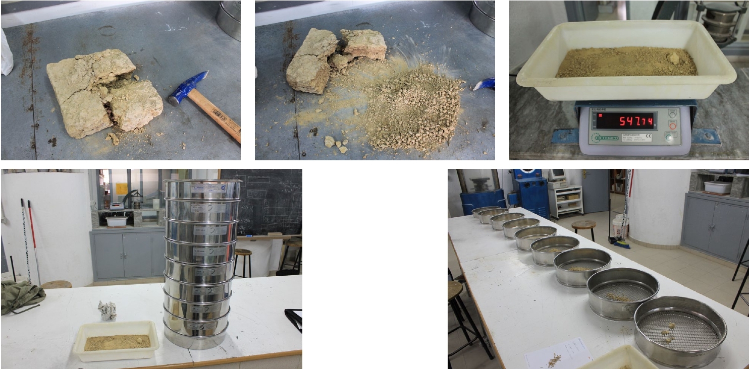
With the rapid evolution of computer simulators such as Google Earth, it will surely be possible in the near future to be able to observe the current state of these constructions in an updated manner from a single file that contains their data. In the last part of this work we will elaborate the analysis for the reconstruction proposal of one of the analyzed samples. The intention of this phase is to put into practice everything learned in the analysis of rural constructions. And relying on the studies carried out in the thematic body, new more precise ones will be incorporated on this construction that reveal the particular characteristics of the chosen building. In this way, a material analysis will be carried out where a more complete geometric survey of plans, elevations and sections will be carried out than the one carried out in the catalog (using triangulation systems), and a study of the system and the composition of the materials. employees in order to be able to thoroughly describe the construction. Through a previous sociological analysis, the determining factors of the social and natural environment and the aspects related to the use to which such a specimen was intended and the property that manages it will be explained. We will reflect on the values that occur to this element and we will determine the way to intervene on the building based on them, and observing the existing damage, the necessary intervention will be determined to provide this construction with a use that is compatible with the circumstances that surround it. .
5. Thematic body 5.1 Study of the physical environment 5.1.1 GEOGRAPHICAL STUDY The Castilian Leonese Community, made up of nine provinces, occupies almost the entire Northern Plateau of Spain and can be considered as an extensive sedimentary valley enclosed by solid mountain edges. To the north, the border with the Cantabrian mountain range reaches slopes of up to 500m, to the east the Iberian mountain range rises up to 200m, to the west the Galician-Leonese massif timidly borders the autonomous limit and to the south-southwest the central system rises on the plateau up to 700m. Only in the southwest, in the provinces of Salamanca and Zamora, does that sensation of a sunken basin that we observe in any of the other borders vanish. It is characterized by a highly continental climate with short, hot summers and long, cold winters. The landscape is relatively flat, only interrupted by certain moors, and is devoid of vegetation, giving rise to a traditional image of inland Spain. The proposed study area, made up of the regions of Tierra de Campos and Montes Torozos, is located in the center of the northern plateau and encompasses the occupation of part of four provinces of Castilla y León: A wide strip northwest of Valladolid , a part of the northeast of the province of Zamora, a small area in the southeast of León and a large area in the center and southwest of Palencia. One of the people who has extensively studied and explained both spaces, perfectly describing their geographical framework, is Justo González Garrido, whose limits have been perfectly known.
Tierra de Campos is a region extended by the four provinces mentioned above. Being a natural region, its limits are somewhat imprecise. In addition, for reasons of a historical, political or administrative nature, there has always been some confusion when it comes to establishing the regional border. Even so, it is confirmed that it is made up of 161 municipalities inhabited by between 100 and 400 residents, most of them, and a global population of 67,400 inhabitants. It is bordered to the north by the Montes de Palencia and by the Cea river in the province of León, to the northeast by the Pisuerga and to the southeast by the Montes Torozos. Towards the south it ends at the beginning of the Land of Pan in Zamora, there by the edge of the Sequillo River and the Villafáfila Lagoons. It manifests itself as an extensive plain with little tree density and gentle undulations of land, dedicated almost entirely to the cultivation of cereals and with such homogeneous and characteristic appearances throughout its extension that make it be considered, without a doubt, as a true geographic unit. As Justo González Garrido describes, "everything in it is uniform: the geological constitution, the layout of the soil, the cultivation to which it has been subjected for thousands of years, the general appearance of the fields, the harshness and aridity of the environment... the general scarcity of fountains, the dazzling luminosity of the landscape, the physiognomy of the old towns that mark it out in its rustic and ancient architecture, whose main construction material is the clay of the soil hardened by the hot summer sun» [26].
The region of Montes Torazos occupies the northwest of the province of Valladolid and the southwest of Palencia. The space it occupies is not a large area, but it constitutes an easily appreciable geographical unit. It is occupied by 39 localities from Valladolid and 5 from Palencia, in addition to another 36 towns, 29 from Pucelanos and 7 from Palencia, which, although their terms occupy the mountains, their urban centers belong to other regions. Unlike other regions with successions of varied landscapes, in this one «the space is unique with a compact uniformity that can be appreciated at a single glance, [...] the entire region appears dominated by a harsh monotony. But this does not deprive it of having differential characteristics with its own physiognomy, nor does it prevent it from arousing an illegitimate interest in the observer» according to Garrido [27] . The region begins to the southwest of Palencia and widens towards the west of Valladolid. Its elevation above the level of the flat lands reaches 150m, dividing the northern plateau into two parts: Tierra de Campos to the northwest and the Vallisoletana Countryside to the southeast. Although the border of the region is given by the topography, the limit of this region coincides with the course of the Pisuerga river to the west and its union with the Duero to the south of the moor. To the west, the Sequillo River runs through its entire length. On the other hand, the small valleys created by the progress of the courses of two other rivers, the Bajoz and the Hornija, which will later pour their waters into the Duero River, fragment the moorland into several pieces to the southwest, giving rise to the name that receives (Torozos — Pieces). The altitude is between 800 and 850m, this means that the image created is that of plateaus with perfectly horizontal surfaces providing a very characteristic relief only found at the head of the slight depressions. Although they are two well-differentiated regions, both due to the topography and the physiognomy of the land and that each of them provides a very characteristic material for rural constructions, mud in Tierra de Campos and stone in Montes Torozos, the appearance of a mixed architecture (earth and stone) detected above all in the border strip between these two spaces allows us to analyze the complex as a space where an interesting progression takes place, object of our study, and define it as a single geographical unit called Campas and Torozos, which has already been treated by other authors jointly in economic, demographic and other concepts, and also gives name to an association [28]that watches over the progress of the economic, social, cultural and institutional spheres of the peoples that comprise it. For our work, the study area includes a space where the greatest interaction between the two regions occurs, taking the entire border strip between the two and adding other surfaces where the way of building follows the trend observed since the beginning of the investigation.
5.1.2 STUDY OF THE NATURAL ENVIRONMENT 5.1.2.1 Geology The geological study is perhaps one of the most decisive for the constructive understanding of these examples of rural architecture, bearing in mind that the normal thing in these buildings was to build with the materials that were most easily available, that is, what the land provided them.
In this way, the composition of the terrain in the analyzed area is dominated by two poles: clay and limestone. The páramos of the Montes Torozos are made up of limestone (white) of high permeability from the Tertiary period for the most part and, although to a lesser extent, by pebbles, gravel and sand from the Quaternary period (bluish spots within the white area). From the emergence of currents (the Sequillo, Bajoz, Hornija and Pisuerga rivers) they leave us in their wake gray silts and clays (in light blue color) from the tertiary period and some added from the quaternary. In this way, although it is an area dominated by stone, there are also the raw materials necessary for the production of clay.
The flat area around the paramos is formed by quartzite conglomerates with a clay-sandy matrix (in yellow) in its greatest extension with punctual zones of marl, silt and ocher clay with sandstone and interspersed conglomerates of a reddish color, all of them of the Tertiary period (more brown tones on the map). Constructively, the limestone platform of the entire páramo, forming a cliff cut almost into a peak as observed in the geological profile (illustration 17), provides good support for safe construction, while the marl and limestone slope presents instability due to horizontal displacements that makes construction unsuitable in this area. Large stone constructions of military or religious architecture have originated with masonry material from known quarries such as those of Villanubla, La Mudarra, Villavieja or Pedrosa del Rey, but also works of popular architecture have been made with stone masonry. On the terrace of the valley, the land is soft, although displacements do not usually appear, so there is good stability, guaranteeing the suitability for building.
5.1.1.1 Topography We have previously commented on the characteristic topographic contour of this place. The reality is that basically we find two perfectly horizontal surfaces separated by a drop of approximately 150m (800-850 altitude of the paramos compared to 700-750 of the valley lands) and connected by a fairly steep slope. In addition, the relationship between the topographic and geological profiles is very powerful as we have observed. However, sometimes this harmony is obviously interrupted by slight changes in relief as described in the following scheme:
5.1.1.3 Climatology Unlike what happened in the geological and topographical study where we found notable differences (and on the other hand expected) between Montes Torozos and Tierra de Campos, the climatological analysis can be carried out jointly, since both regions have similar characteristics.
temperatures The continental climate causes somewhat extreme situations with harsh winters and hot summers, even "sometimes experiencing oscillations greater than 25º within the same day and reaching differences of 48º throughout the year on extreme days and times" [29] . Winters are harsh and long. From October-November, temperatures below the freezing point of water can be recorded at night. This situation can last until April, with the months of January and February being the most extreme. The winter average is around 5“. Springs come somewhat late and are usually very brief and turbulent, because at the end of May the summer heat begins to come, reaching maximum temperatures of 40º in July and August with violent drops on some days in August-September, the average being in summer 24º. This motivates the construction of constructions with thick walls that isolate the interior space from both cold and heat. And in this case, the clay enclosures found in many popular buildings, especially in Tierra de Campos, perfectly fulfilled this mission.
winds Almost all year round the wind blows strongly in this area, cooling the summer and reinforcing the appearance of frost in winter. There are two main registered directions in this zone: the one that comes from the northeast, called “cierzo”, which is registered mainly in the extreme months of cold and heat; and the winds from the opposite direction that are recorded in spring and autumn dragging the humid Atlantic atmospheres and accompanied by rains. This data is interesting because the aggression of the rains accompanied by winds represents an advance in the wear of materials, especially mud. Therefore, it can be decisive for strategies to better protect buildings.
precipitation The fact that the study area is located in the central precinct of a space surrounded by mountains that prevents to a certain extent the passage of large fronts means that the rainfall regime is moderate during the year, as we can see in the illustration 21. In addition, we observe that its greatest presence coincides with the area less delimited by mountain ranges (southwest). According to the data from the climograms in illustration 19, it can be verified that both regions register similar levels, slightly more rainfall in Montes Torozos than in Tierra de Campos, and they always occur mostly at the equinoxes and in the winter months. Snow and hail do not usually appear more than 4 or 5 days a year. This scarcity of rainfall has resulted in the appearance of roofs with little slope, oscillating between 25 and 40% on average. On the other hand, this fact has meant that well-executed rammed earth and adobe walls have been preserved for a long time without the necessary annual coating layer.
5.1.2.4 Hydrography and vegetation
Hydrography It has already been commented that the presence of certain rivers and tributaries is notorious (see illustration 16 in the geological map ), however , their flow is irregular and generally low, mainly conditioned by the rainfall regime, which we have already verified . which are also not high. Only the passage of the Duero represents a hydrographic importance. In general, the environment is mainly dry, especially in the flat areas, interrupted by the surface-type aquifers found in the moorland area.
Vegetation The vegetation of the páramo has suffered a great deforestation since the confiscation of two centuries ago, the creation of cropland remained. This deforestation is currently causing the disappearance of native vegetation composed of oak, juniper and quejo. On the slopes and flat lands much less wooded than long ago, the pine is the dominant one. In any case, the existing panorama is characterized by the scarcity of wood and, together with the high cost of this material, means that its appearance in popular buildings will be reduced. On the other hand, and following this same trend, the low abundance of combustion material reduces the manufacture of ceramic elements such as tile and brick, intended for only two materials, clay and stone, such as those used for these humble constructions. .
5.1.3 STUDY OF THE POPULATION In this area of study, Campos and Torozos, the relationships between the environment and man are powerfully sensitive, they are closely manifested and preserved in a pure and direct way. An almost exclusively rural and dispersed life develops, away from the disturbing character generated by the industrial environment, and traditional habits, modes and manners entirely appropriate to the natural environment in which they develop are easily created, vividly reflecting the physical conditions through the facts. social. 5.1.3.1 Demographics The basic demographic indicators, birth rates, mortality and vegetative growth, indicate a progressive decline in the population, with an increase in the number of deaths in an old society and a slight decrease in births in the last five years. The pyramid in the area of "Campos y Torozos" is bulb-shaped. The base of the graph, which indicates the youngest population, is very small, while the widest band corresponds to ages between 55 and 65 years. The birth rate is so low surely due to the absence of women of childbearing age in search of job opportunities in more urban environments, also resulting in a low marriage rate and child population. The migratory movement to the cities is not a new effect and for half a century Justo González Garrido [30] warned us of the depopulation of this area. This further accentuates the bulbous shape of the population pyramid. If years ago the decrease was produced mainly by this urban migration, today we have to add to this procedure the decrease in the birth rate, which means that the towns of these regions are gradually becoming vacant, filling up with empty houses.
Another data of interest is the demographic density. In Castilla y León we are talking about 26 inhabitants/Km 2 , while the national average is 79 inhabitants/Km 2 . But in the area of Campos and Torozos, the density drops to 11.67 inhabitants/Km 2 and if we assess this situation independently by municipality, we find ourselves in a more critical situation, since towns such as Medina de Rioseco have the highest density, leaving the rest with very low levels [31] . There is no doubt that this trend will cause the extinction of certain towns, and according to what was seen in the tours carried out during this study, where we have found certain towns without an inhabitant walking their streets on days and hours when it would have been normal to witness some social contact, this effect will not take long to occur. We are, therefore, facing a compromised situation, how are popular constructions going to be preserved if the municipalities to which they belong are not even going to be able to be maintained? This aspect is of special importance to understand the evolution of the constructions that we are studying.
5.1.Z.2 Economy For the economic study, it is crucial to understand the evolution suffered a few decades ago, at a time when rural constructions had an activity consistent with the one for which they were built, up to the present times where their use has almost disappeared. When talking about the economy in Castilla y León, agriculture is quickly thought of as the main economic activity considering the large area of cereal cultivation that exists, and in fact until not long ago it has been so. In the 1950s and 1960s, when industrial development began with the appearance of Fasa-Renault in Valladolid, which globally energized the entire community, the primary sector that had occupied most of the economic system began to suffer a decline in favor of the industry and services. In the province of Valladolid, agriculture now represents only 1% of employment in the productive sectors [32] . The mechanization of the countryside has been increasing, perhaps excessively, and this has caused the reduction of agricultural wage earners motivated by the increase in machinery that replaces their work. This effect translates into more rural-urban migrations. Regarding the type of crops, rainfed crops have always been more abundant than irrigated crops (although thanks to the irrigation canal systems and use of the water table they have increased) due to the climate and the lack of rain, with wheat being the traditional element, but currently barley, which has replaced it, and sunflower dominate the fields. The vineyard is the only woody crop that has a certain size. Livestock has been the other traditional element of production, but despite having doubled in the last 20 years, it has undergone numerous changes such as the reduction of sheep (the most important until the mid-twentieth century), horse and goat farms, the increase of cattle and pigs and the expansion of poultry farming [33] . This is another kind of cattle. If we evaluate these facts, we realize that until 60-70 years ago, due to the labor occupation that exists in rural areas, human beings saw the need to build unique buildings to be able to carry out their field work, either for the storage of the heavy field work utensils, for rest in the hours of rest or to spend the nights in the long summer days inside what many called "summer squares". The surveillance of the crops (of the vineyards in many cases) or the grazing shelter have also benefited from the creation of these elements that have sometimes expanded their size to store livestock. The industrialization of agriculture has been produced with machinery so heavy that it has dwarfed the popular constructions of rural architecture. The mechanization of livestock has led to the proliferation of large buildings that have made small shelters useless to graze. Seeing these events, it can be understood that the conservation of the elements that occupy our work has been seriously damaged to the point of being considered as insignificant and marginalized constructions by the people of the rural area.
5.2 Case studies Through all the cases observed on the routes traveled through the lands of these two regions, we are going to establish the most characteristic features of the auxiliary constructions of this rural architecture. Being able to classify and catalog these examples is a sample of the architectural value that these buildings possess. On the other hand, the description of its materials and the techniques used for the elaboration of its constructive elements supposes the main compression tool of rural constructions.
5.2.1 TYPOLOGICAL STUDY There are three factors that we are going to study for the classification of each observed sample. The first is related to the dominant stone-mud polarity in each sample. The second lies in the formal and volumetric composition of these constructions that we will differentiate in terms of the geometry of the floor plan on the one hand and the roofing system on the other. The last one deals with the combinations that occur between several buildings according to what has been observed.
5.2.1.1 Evolution of the predominant material As we have already mentioned, the popular architect is characterized by the good handling of the materials that the land itself provides. In this case, through what is observed in the geological map, we realize that there are two predominant raw materials in the studied territory: limestone in the Montes Torozos area and clay in Tierra de Campos. Bearing in mind that the two main materials are at hand in the border areas between the two regions, we can, as a first approximation, establish three groups with respect to the component with which they are built: - The first of these corresponds to constructions entirely made of clay, with adobe and rammed earth as the main techniques for their execution, although it must be recognized that they are sometimes supported on stone elements as a foundation system for the most unstable soils. . (upper image - illustration 26).
- The second group is that of a mixed architecture where stone masonry is combined with clay, the latter always in a superior position, leaving the stone material as the plinth or supporting wall of the construction. (centre image - illustration 26).
- Finally, in the last group we find those examples created only with stone. (lower image - illustration 26).
According to the buildings that have been found through the documentary methodology (those that with a high degree of information allow their classification, according to those that have been observed through visits and analyzed live, and according to the polarity established by the study of the terrain we can establish a situation framework supported by the geological map in which the geographical-constructive tendencies of the three main types are explained by means of the location of the samples. As the map is presented, what we can describe for the moment is that according to what has been studied, the exclusive mud constructions usually do not approach the limit of the Montes Torozos, reserving only the flat area, without any exception, since that any construction found that had mud rests at least under a plinth or well-consolidated stone wall. It is also observed as a general line that as we enter the moors where limestone dominates, the stone gains strength as a construction element, except for a few cases where we find some sample on the coast of the moors, but no appearance outside this strip. The cases of stone-influenced earthen architecture are more widespread throughout the territory, occupying the entire map and abound especially in the intermediate zone,although we also find some cases in the plain and in the interior of the mountains.
Obviously the appearance of the stone occurs at the moment in which it is provided by the land, and, although it is a logical fact, it serves to confirm one of the principles of this type of architecture, which is to use the most access. We cannot forget other factors, such as the economic one or that of the constructive tradition spread by other places that can explain certain irregularities in the general trend and that we will progressively reason about. On the other hand, once we have defined the two poles that we find, observing the intermediate phase, that is, those examples of mixed construction, we realize that the typological variety in terms of the presence to a greater or lesser extent between one material and another within the sample itself increases to unexpected levels In this way, further breaking down this intermediate architecture, we can establish up to seven different types in response to this question, which are represented in the following typological scheme:
Type 0: Corresponds to those examples made with rammed earth or adobe with a domed roof (always made of adobe), or inclined (normally with a wooden structure and curved tile), where the stone has no appearance, except for the possible foundation that is done with boulders normally. These elements still belong to what we call the ground pole. If the mud walls rest directly on the ground, they are usually protected with small elevations of land to prevent water from entering the interior.
Type 1: The constructions that are part of this group incorporate a small stone plinth to the foundation up to an approximate height, generally, of 50 cm, which gives them greater protection against ground humidity. They may have sloped or dome-shaped roofs. From this type begins the evolution of stone. The rammed earth and the adobe can appear independently or combined.
Type 2: The stone advances up to a height of 1m, reaching the middle of the access hole. The examples formed by a ground floor with a sloping roof are generally integrated into this set. Those with domed roofs do not usually appear in this group, at least we have not found any and in these cases the masonry usually reaches higher levels.
Type 3: This group includes those constructions that have two floors. The stone reaches the carpentry of the openings so that the lintels rest directly on it or, at times, even the support of the floor beams. The rest up is mud. They always have a sloping roof and a rectangular or square floor plan. Type 4: Here are very interesting examples with domed roofs made of adobe. The stone reaches the point where the dome is born, which usually coincides with the upper limit of the access hole, although on some occasions the landing rests on the first row of adobes on the roof. There are generally circular and square plants, although we have found a rectangular one.
Type 5: The examples of this group are those constructions whose roof is or has been at some point linked to mud. Sometimes a double roof can appear: the interior of adobe is the one that manages to give the dome shape, and then either stone elements have been incorporated at the beginning of the dome or the roof has been directly executed on the outside with stone masonry. In other situations it has been possible to see that a stone roof has collapsed and the repair has been carried out with adobes whose technique provides a better solution due to its handling and lightness. Type 6: This set is represented by the other pole, the stone. Here those constructions completely made of stone have been introduced, including the dome or the stone wall and the gabled roof normally resolved with a wooden structure and curved tile. But the reality is that they present an appearance and a way of building that shares similarities with the other examples studied related to clay.
5.2.1.1 Composition: floor and roof For the analysis of the previous section, it was already differentiated between all the exposed types those that presented a sloping roof from those that presented it in a pointed dome. The truth is that the decision between executing one and the other depends fundamentally on two factors: one is the economic feasibility and obtaining the necessary material and the other has to do with the construction process. Regarding the first, it must be understood that the pitched roof with one or two pitches (these are the two simplest and most common types found) requires a wooden structure, a material that is not very abundant in the entire study area and more expensive than the others that it provides. the land. On the other hand, we have also verified that volumetrically the examples we have seen represent very simple objects, all of them with a square, rectangular or circular floor plan, and in all of them we find the different roof possibilities: inclined to one or two pitches and domed, although each one with its particular characteristics. In this way we can represent this formal classification in the following table:
For rectangular floors, the most developed roofs are the sloping ones. Many cases of these have been found and in very good condition, since many of them, due to the fact that this type of plan and roof allow the creation of larger elements than those created with square or circular plans, have allowed them to continue being used for agricultural activities. We have seen some restored, such as in Villafáfila (see «vfI01» in Annex 1). They are generally more modern constructions than the others since their dimensions, which range from 3 to 5 meters wide and approximately 6 to 9 meters long, have adapted better to later times. It should be noted that, although it is not usual, we have found an exceptional case with a rectangular floor plan and a dome-shaped roof in Bustillo del Oro (illustration 25) resolved in a pyramidal way and that we will explain later in the construction analysis (see also in «bus01 » in Annex 1). Regarding the models with a square base, the most found have been produced with a dome, especially those made with adobe in the Tierra de Campos area. This is a very common case, always solved with the corner chamfering system (using different possibilities that will be explained later) until the octagon is formed, which is a good base for the beginning of the circle that starts the roof. The corners are finally resolved with the formation of polyhedrons made of clay that were established in accordance with the dome and the supporting walls that served to prevent the accumulation of water in this part of the model. Some examples with a sloping roof and a square base have also been found, but they are not as common as the others.
With a circular floor plan, the simplest thing constructively is to adapt the circumference to the beginning of an adobe or stone dome. We have found many cases like this, where we can differentiate those whose roof starts from a vertical wall, generally made of stone, like those that appeared in Urueña, from those that start directly from the ground, like those seen in Torrecilla de la Abadesa (see both in Annex 1 in URU and TAB). Curiously, we have come across several, although not many, with a circular base and a sloping roof. These are elements with a certain complexity, but well resolved, like two from Villavieja del Cerro. Normally these cases occur when there are difficulties in closing the dome or if the size of the construction in plan is very large and an excessive height is sensed on the roof, as some neighbors of the cases studied have confessed to us. On other occasions, these sloping roofs appear as contemporary solutions to fallen domes.
5.2.1.3 Groupings In addition to the different types of examples found in terms of the two concepts explained above, the possible combinations observed along the routes carried out are also interesting, which, although not very numerous, at least those that survive, form elements of great beauty. From what we have verified in the on-site analysis, it is normal for these groupings to occur as a result of annexations of new elements over existing ones without internal communication between them, so it is not an extension of the building. , but it is another new construction to add another complementary use to the complex. As far as it has been possible to verify, six different types of groups have been located, which are explained in the following diagram:
CD1A 4 RC2A: It is a simple way to combine two orthogonal floors with a sloping roof on both. Sometimes their union coincides with the separation between two eras and in others they are combined within the same plot with different purposes. Although normally the construction of the two bodies does not take place at the same time, it is not ruled out that they can be done simultaneously. 2 x CDCU: The combination is produced on two square bases with a domed adobe roof. The cases found normally correspond to bodies from different plots of land, but with a similar use. In this type of situation, both constructions benefit from each other, since the common wall is protected from the elements, as well as improving the thermal behavior of the whole.
3 x CDCU: In Tamariz de Campos there is the only triple case of combination of elements. They all belong to the same era and none of the bodies communicate with each other. It is a very peculiar construction and according to direct sources it was done all at once. CICU 4 RC1A: This combination is the most complex of all since the intersection between a pointed half-sphere and a parallelepiped occurs, however, the execution in all the observed cases is very correct. It is confirmed that normally the hut that was used to store grain or to shelter traction cattle was built after the hut that served to store work tools. CDCU4 RC2A: Very similar to the previous one, except that the plan of the hut is square and the roof of the shed is gabled. We have found this case with mud as the dominant material and also with stone. It treats of very versatile constructions for the agrarian activity. CDCU 4 CICU: A special case has been found where the union of two bodies allows the passage from one to the other. Possibly their execution was done at the same time. One of them houses a well and the other was used to store the farming implements. 2 x CDCU4 RC1A: We have found a case where three unequal elements are combined. They are two square huts and a rectangular shed. This is a unique case in the entire region studied.
5.1.1.4 Global scheme and partial conclusions The total number of samples examined in the present work amounts to 89 individual elements and 18 combined in two or even three buildings in some cases, reaching, therefore, 107 elements analyzed and that make up 127 constructions found in 43 towns visited. Although we are aware that it is still possible to locate more examples thanks above all to the collaboration of the residents of the towns visited, who have indicated more places to explore and that will be addressed for future work, we are going to make a table classificatory as a census, ordered by municipalities, which allows us to detect the number of stocks that there are of each type of construction, relating all the concepts that we have addressed in this section and locating them in each locality. In addition, together with the table, we have also made a typological conceptual scheme of all the possibilities found that can occur in the area studied and have also been related to all the towns to which they belong. These documents are shown below. CLASSIFICATION OF SAMPLES BY MUNICIPALITIES ACCORDING TO TYPOLOGICAL CONCEPTS
TYPOLOGICAL CLASSIFICATION OF RURAL AUXILIARY CONSTRUCTIONS OF CAMPOS AND TOROZOS
TYPOLOGICAL LOCATION OF RURAL AUXILIARY BUILDINGS IN CAMPOS AND TOROZOS
Partial conclusions On the exposed graphs we can determine that most of the constructions correspond to a mixed architecture, as it was foreseen at the beginning of the work. Next, the most common examples are those made of stone, compared to those made of clay. However, it must be taken into account that the stone samples survive more over time than those made with earth and the ideal would have been to have made this balance fifty or sixty years ago when the users of these buildings used them and they were kept in a decent state, optimal to be able to evaluate these criteria. That is why we cannot draw decisive conclusions either, since, on the other hand, we imagine that it is possible that the local masters would have executed more mud than stone constructions, since clay, Even so, analyzing the data obtained and with the intention of observing the typological trends, we can further break down the mixed architecture and appreciate that the cases with the highest proportion are those of type 1, that is, mud constructions on stone plinths, forming buildings solid that have allowed to better withstand the meteorological action. The other types appear smaller, perhaps due to the excessive specification of cases and for this reason the percentage of stocks is distributed more. Regarding the plant, the most found cases are those with a square base, occupying more samples than those with a circular or rectangular plant. As for the roof, the data is even more voluminous, with the dome being the most commonly found element of coverage. Although it is true in this work, more emphasis has been placed on those small agricultural constructions that have a domed roof of mud or stone, as they are considered works carried out in a humble way by their future users, than on those with greater spans saved by large sloping roofs that are normally more modern buildings made up of rectangular floors. Finally, the data from the study of combinations may be more accurate, since in this section an attempt has been made to verify all the possibilities of union between different elements. In this concept we have to highlight the construction of small elements such as square or circular huts combined with rectangular huts with single or gabled roofs, these being the ones built later.
5.2.2 CONSTRUCTION STUDY Next, the construction processes and developments that the «rural architect» has used to transform a raw material such as earth or stone into building forms that he uses to carry out his daily activity will be described.
5.2.2.1 Materials There are two materials that we will deal with, since they are the basic ones that we have found in the analyzed constructions. Apart from stone and mud, popular architecture has also been developed with wood and brick, however, the fact that the arboreal surface of the regions we are dealing with is minimal reduces the appearance of the former, and due to its capacity of combustion, also that of the second. However, there are also constructive elements made with all the mentioned materials that will be adequately described in the given cases.
the mud We are faced with a material with a very simple composition. Mud is nothing more than a mixture of soil with water, or soil with water plus an organic substance (straw, lime, stone,...) that helps improve its properties or predisposes it to a specific application. Its great abundance and ease of extraction and processing make it a low-cost element. This, together with its ability to be mouldable, explains why it has been a material used for a long time for numerous applications. Without being able to establish an approximate beginning when building with earth in history, it can be affirmed that human beings have been using mud in their buildings for at least 10,000 years, as evidenced by the Neolithic deposits in Catal -Hüyuc in Turkey. But the most interesting thing about this fact is not that earth as a material has been part of our constructions for so many centuries, but rather the way in which the manufacturing and construction processes of clay were developed, the techniques that have been used to erect walls or barriers, the tools used, or the different compositions of substances to form the material or the number of people required for its construction, have not undergone a very relevant evolution over the centuries. Obviously, each country or region has developed some characteristic methods related to the qualities of each territory, more in a material that depends a lot on the terrain, or with the inheritance of a certain style of construction. Here in Spain, the Arab contribution that took place from the 13th century was very important, at which time there was a renewed version of the techniques for working with clay, although later, from the 18th and 19th centuries, we We find great documents from architects, historians and treatise writers that explain the correct use for the creation of earthen buildings. Today, together with the abandonment of this humble way of building in our closest regions, there has been, in parallel, a return to the use of clay in other parts of the planet, giving several contemporary examples of great interest in Asian or Latin American provinces where these techniques have been followed or re-practiced. Currently "more than half the population lives or works in buildings made of earth" [34] , despite the progressive disappearance that has been and continues to occur in Europe. To explain its great constructive qualities, the text exposed by Mariano Olcese Segarra is cited, on an article that appeared in the General Magazine of Architecture and Public Works of 1840, which on the construction of raw brick says the following: «On a base of this class, a mill, with four floors and three grinding wheels. This plinth, which is no more than a meter thick and over three meters high, has lasted like this for twenty years, without the enormous load that supports it having weakened it»...«a house and a vast sheepfold , which had been built in this way, on the same property have burned down, without their walls having suffered the slightest deterioration»...«the houses built in this way are dry, hot in winter and cool in summer, and very healthy»... «when the walls have several sections of existence, their cohesion is such that door and window openings can be drilled without establishing the supports for the upper molding (loading)» [35] However, this material presents a problem that has to do with the wear it suffers from meteorological action, since it needs special care for its conservation. On the other hand, its manufacturing process requires time and waiting until the precise date to be able to carry out the proper preparation, which can be an inconvenience to recover its use. Even so, and according to José Luis Alonso Ponga, "there is no rich or poor building in traditional architecture that does not have a debt with this material" [36] since clay has been an element that we have been able to find in numerous situations and in very diverse ways. shapes. Its most interesting applications in the world of construction are the following: As a mortar to join rounded stones (in old public roads it can be seen), or stone masonry. For coatings, exteriors or plasters, mixed with straw, on walls, especially rammed earth and adobe to preserve them from humidity; and in the interiors or plastering that were sometimes painted with decorative elements. As filler and reinforcement of walls and partitions of frameworks. For the wall construction system. As an element of adobe construction.
The stone We are dealing with a heavy material that nature provides directly, expensive to extract and transport and normally difficult to carve for its implementation. However, it seems that it is the material that provides greater stability and resistance against external aggressions. This fact allows us to ensure that there is an immemorial vocation to build in stone since it appears in all kinds of works and cultures; Whenever there is stone available in the place or in nearby areas, it appears in everyone's head as the first option to build. As stated by Roldán Morales [37] , stone architecture arrived on the peninsula with the Romans and later with the invasions from northern Europe, being «clearly a material of Nordic tradition as opposed to brick and earth, of a more Mediterranean tradition» . Although it is a material that can be treated and shaped, unlike what happens with clay, this element does not need a mold or formwork to form solid pieces, and we frequently find constructions made with this material placed according to the terrain. or with the remains of fallen buildings. Stone has always been part of all kinds of historical constructions, where daring stone solutions have been developed through architects and stonemasons that reach the limits of their physical characteristics, giving rise to an architectural history rich in examples of this type. As far as its use in rural constructions is concerned, we are moving away from the boasting and the spectacular nature of cultured architecture. There are no complex structures or dimensions that limit the use of the material. These are works that offer as values, simplicity, resolution based on ingenuity and the development of simple and free solutions that this material allows. Despite the fact that in the center of Castilla y León there are no mountainous areas prone to yielding a large surplus of stone, the Torozos moors are an exception and also offer limestone quarries, providing a sufficient amount of stone for popular constructions. This type of stone can be used in masonry and masonry walls. Its extraction in a quarry generally gives rise to large and prismatic pieces, which can be divided and carved. However, in rural architecture it is normal to find irregular masonry walls, with large pieces and small gravel. However, a trend is observed not only quantitative but also qualitative in the use of this material as we enter the interior of the moor. As Juan Manuel Báez Mezquita says «it is evident that, if a region has good stone materials, a rich tradition of stonemasons will appear, ... the materials generate expectations, needs, create a school, create tradition in their use, trade and transmitted wisdom. ›› [38] .
5.2.2.1 Construction systems and techniques Through all the examples that we have examined in various towns of these Castilian regions, the systems and techniques with which rural constructions are carried out have been studied and which we will explain below.
VERTICAL ELEMENTS. WALLS AND FOUNDATIONS
the wall The tapia, or tapial, as it is usually called in the lands of Castilla y León, is a wall built in situ about 50-70 cm thick between two sides (1 in illustration 41) and two cross sections (5) that act of formwork and that will move laterally or vertically according to the progress of the work. The side boards (the mud walls and hence their name, since they cover the ground to run) are joined at the bottom by wooden crossbars (4) and separated by some boards that act as separators (6), at the top They are held and tightened by means of rope struts (7) collected by uprights (2) that are held with wedges (3) on the lower crossbars. In most situations they are supported on a small stone plinth that rises from the foundation, they very rarely rest on the ground (only if it is very stable). The mixture that is introduced inside is compacted by blows by means of a tamper (8). They are normally built with water and earth, although sometimes they appear with straw or lime to improve their resistance and prevent cracks and other times, even with gravel, which is something similar to concrete whose technique is similar. Its percentage of mixture varies from one town to another, normally depending on the type of composition of the land and the way of building each one. In Tierra de Campos the components are distributed as follows:
The elaboration process has a meticulous methodology to achieve an adequate construction. The soil is usually first dug up in September and piled up until spring, so that the frosts eliminate unwanted vegetable organic substances, since these can harm the stability of the whole. Then the execution is carried out at the end of spring and at the beginning of summer when a better drying is carried out for the consolidation of the walls. 4-5 people are involved in its construction phase. The teacher is the one in charge of tamping the earth poured into 10cm layers with a mallet or wooden rammer. For the execution of the holes, the fences are previously placed so that these are received in the mass. In some more advanced constructions, adobe bricks or masonry jambs, called brencas, appear for the formation of holes or in the corners, constituting a reinforcement for the weakest areas. For the consolidation of the walls, the rammed earth sections are made first horizontally and then vertically out of phase as if they were rigging like the bricks. When external agents erode the walls, the lines of the different temporary phases of execution can be perfectly observed, as well as the gaps left by the crossbars that join the side boards.
The Adobe It is a mass of clay in a much smaller format 40x20x10 cm. approximately, which allows it to be combined by means of different rigs. In addition, the small size offers many more possibilities than the wall when it comes to building more types of elements (walls, arches, domed roofs, ...). Unlike rammed earth, it almost always adds straw to its composition that facilitates interlocking and consistency and slows down the tendency to crack due to retraction. This artisanal process begins near a stream of water to facilitate its transport, where a large hole is made, between one and two meters deep, where the earth that is crumbling spreads in a layer of about 40 cm and is soak generously with water to let it settle for a day. After this time, the hoe is cut and the mud formed is moved. Then threshed straw is added to the mixture, kneading it with the feet or with the help of an animal as was done previously where their excrements or even their blood were used to improve the resistance of the mud. Later, Once the compound has been formed using a rack or adobera, the adobe bricks are prepared to let them dry in the sun for two days. Later they are left in a vertical position so that the air and the sun hit it on all sides. That is why this handmade process begins in the spring avoiding frost that interrupts the process. (See in Annex 3 the steps described by Erhard Rohmer in Navapalos 85).
For construction, adobe usually forms 45 cm walls on a stone plinth, although sometimes this plinth is formed by the adobe bricks themselves, in this case the wall would be protected from moisture by a small slope. From the cases studied we observed two different types of gear. The first is a blight rigging where the adobe blocks are arranged passing through, occupying the width of the wall, solving the corners with pieces three-quarters of the length, which allows the courses to be offset to generate a more solid wall. The second combines rows of tailings with rows of double rope, also using smaller pieces in the corners. With the double-rope sections, sometimes one of the adobes is removed to create a small hole that is used to support wooden crossbars or other construction elements.
The two techniques, rammed earth and adobe, can be displayed independently or in combination. The usual thing for consistent walls on the ground floor is to use rammed earth and on higher floors lighten with adobes, although we can also find adobes on ground floors, in domes for roofs, and reinforcing gaps in the facade, the corners of rammed earth walls and also in the supports of the wooden structures of the roofs. For small auxiliary constructions, the most common is to find adobe as a construction method, because it is more manageable. It is interesting to discover through the cases studied how these two techniques for making orthogonal prisms are so decisive when building, that the constructive dimensions of these examples normally have strong relationships Sometimes the thickness of the wall coincides with the length of the adobe , or special bricks are made to form the corners of the walls, and even the total dimensions of a construction can be measured in number of pieces of these elements and not in meters, as in contemporary architecture.
stone masonry To improve the quality of the enclosure of these constructions, it is important to incorporate a stone element mainly in the area of contact with the ground that protects it from humidity and provides greater stability to the whole. Although not all of them have this, due to lack of material in the area where they are located, there has been a concern on the part of the popular mason to introduce this component. It has already been mentioned that in rural architecture there is no room for boasting or for complex elements, hence all the elements made with stone have used pieces of a relatively small size that allow placement by hand (hence the word «masonry» — laid by hand, as Juan Monjo Carrió [39] explains, without the need to resort to pulley winches or other instruments necessary for large stones. The truth is that both the dimensions and the shapes can vary from one town to another depending on the nature of the place and whether there has been any important construction tradition close to established quarries. The way it is placed and seated also varies. A primitive system is to assemble them "dry", without the help of any mortar, appearing on the walls of sheds or in places where the insulating function is not necessary, using the use of slabs and gravel to improve the settlement of some stones with others. A more advanced technique is the one that uses mud smears in the gaps between masonry and improves the wall's consistency and thermal performance. The latter has allowed many examples to still stand. The definitive solution would be the masonry received with lime mortar, but this is only observed in housing complexes or in more contemporary actions.
Depending on the shape and arrangement of the pieces, we can highlight the following types of masonry located in the study area on rural constructions: Ordinary masonry : arrangement of pieces without dry work or with mortar, trying to adapt some stones to others so that they are as close together as possible. Yes, it is dry, they use rubble that acts as wedges. It is the most seen type, especially in the poorest buildings. Faced masonry : it is made with elements that have one of their faces carved to ensure that a wall has a relatively flat surface. We usually find this in a wall and in the formation of holes where a carpentry will later be incorporated. Concentrated masonry : formed by elements whose joints are treated to achieve a correct settlement between the flat faces of these polygonal pieces. If the stones are very rectangular, masonry can be made in rows, forming very compact sets. This type can be seen in less humble constructions and in places with a long tradition of using stone. Masonry with rounded edges : it is used for foundations using this type of hard stone mixed with a large amount of mortar.
COVERAGE ELEMENTS
adobe domes One of the most interesting elements, both from a constructive-structural point of view and from an aesthetic point of view, is the formation of domed roofs made of clay. Mainly two types of covers have been observed that will depend on the placement of the adobes: the authentic one and the false one. The first consists of the creation of frustoconical compression rings formed by adobes leaning towards the center of the circumference that is described at the start of the dome. Actually, the roof is like a pointed vault from pointed arches. The execution process is amazing, similar, saving the distances, to the great domes of churches and other monuments, made of stone or brick; only that for these it was necessary to previously locate some wooden centerings that would keep the pieces well secured in one place until they closed at the top of the dome. But this development could not be used since the falsework would cost several times more than the entire construction; so the local master managed with few means, relying on his expertise and the adherence of the mud, a much more surprising adherence than we imagine, until he achieved the desired result.
In the false dome, made by approximating rows of adobe, horizontal rings with a smaller diameter are created as we ascend, so that they are staggered. In reality, the cover is even more pointed and shaped like a bullet. This ogival character is based on two causes: the first is that with this approach system or successive flights you are forced to shore up the highest section, since there is a risk of balance failure due to the excessive staggering for the final curvature and surely the last bricks would fall; the other reason is that with this model the rainwater is evacuated more quickly in a material that is greatly affected by rain harass.
The result observed is magnificent as can be seen in the specimens still standing. In some towns they call these constructions homos due to the similarity of their vaults that are partly reminiscent of Islamic construction. In other places, casetas de era if their enclosure plan was square and chozo if it was circular. What is clear is that it is one of the most interesting elements that have been analyzed. After understanding how these covers stand up from the two-dimensional perspective of the section, we now have to look at their position in plan and from the three-dimensional model. In the first place, it is necessary to understand that these bricks should be placed in such a way that their longitudinal axis coincides with the radius and the transversal crosses the arc of the plan projection of the rings, in this way it is easier to achieve the curvature. It is at this point that the first question arises, which is to know if these blocks are rectangular or trapezoidal, on the one hand, and on the other, if, if they were trapezoidal, how this special shape would be manufactured. According to what has been verified, the adobe bricks at the start of the roof usually have a rectangular shape since we are dealing with the largest rings and therefore the slight curvature does not differ so much from the orthogonal shape of the adobe. In addition, to achieve good cohesion between the blocks, pieces of stone were introduced between them on the outside of the dome to act as a wedge, like the rubble in stone masonry walls.
But inevitably this is not a solution for the upper rings, since for these sections the stone would occupy more space than the mud. This is why we find the trapezoidal shape as we head to the top. As to whether these adobes were conscientiously manufactured in this way or whether they were cut once removed from the mold, or directly split as is currently done with conventional bricks, we are not sure of confirming any of these theories. The creation of a trapezoidal adobe is not complicated since there are four wooden boards and we are aware of the existence of a similar one, but in reality each ring of the vault should have different trapezoids and it is difficult to think that for a construction of this kind had such a variety of racks. Thanks to the notes that we have taken from researchers (Roldán Morales, Carlos Carricajo or Mariano Olcese Segarra, among others) on topics similar to the treaty and what we have been able to verify in the face-to-face analysis, what we can guarantee is that in many of the Roofs that have been observed can have up to 3 different formats of adobe in the same dome. And the truth is that with a couple of adoberas (one rectangular and the other more pointed) and different strategic cuts (illustration 52) you can get different pieces for an effective execution. Although it is also possible that the adobes could later be split. On the other hand, two types of adobe rigs have been identified, one with a double rope, and another with pass-through elements, including the combination of both styles. A variant of the roofs by approximation of courses is the pyramidal system based on square or rectangular plans, in which it does not require corner elements to chamfer and convert the plan into the octagon prior to the dome. The edges are resolved with adobes cut in triangular shapes that help to soften the whole. The molding capacity of the clay subsequently transforms this pyramid into a beautiful pointed element through the protective layer made of earth and straw that chamfers the straight edges into curves. Although we can mainly classify two types of adobe roofs, the authentic one and the false one, each example that presents a mud dome, this one is different from another and solves the situation with a different solution. even execution errors are solved with performances that are less interesting.
For example, in Valderas (León) we find a case that has now disappeared, which, starting from a completely circular plan, is executed with two arches with different inclinations, possibly as a result of some repair, passing from the circumference at the beginning of the dome to a kind of ellipse at the coronation. In this case, the curvature is made by approximation of yarns until the vault is closed.
stone roofs While the adobe roofs have been seen in almost all the observed territory, the stone ones belong exclusively to the paramo where the excess of stone material is used for its construction. Here, as in the clay ones, we can find two main types, the authentic dome and the false one, although there are also some very irregular ones made in a more archaic way. On the other hand, and as a general rule, these roofs are executed with a double dome. The interior is made with very polygonal pieces (some even carved) even to find some of mixed construction helped with adobe for the realization of the curvature, as a much more effective element, following the model of the typical ones of the plain. The second layer, the outer one, is usually made with much more irregular stones and in the case of the mixed ones, they protect the mud from the meteorological effects that cause its ruin. The mixed solution seems good for the development of these structures, however, it has not been possible to find any in perfect condition, they are all semi-ruined. It is possibly due to the poor compatibility of these two materials, and as Carlos Carricajo [40] warns, the stone does not join as well with the clay as it seems for domed solutions and that is why we frequently find them bare with pieces of adobe and stone that have fallen on them. inside.
In any case, those that are presented with an authentic roof almost always contain adobe inside, since the stone used for these examples, almost always irregular, only allows the execution of a stepped dome, which when this is the case tends to lighten towards the culmination with much smaller stones.
Among those that are purely made of stone, we have found one of great quality, bordering on what we could define as cultured architecture to differentiate them from rural constructions. It is a caseta in Montealegre de Campos (illustration 57), with a square plan on the outside, but octagonal on the inside and with a three-layer roof section. The interior made with very regular polygonal elements forming an authentic dome following a certain inclination in each row, also accompanied by a slight approximation as in the false roofs; the intermediate one is formed with irregular stones as filler; and the exterior resolved with thin slabs forming four faces with a spherical section adapting to the exterior walls and solving the key with a horizontal piece that closes the roof as a cover. interesting architecture for a rural element of humble necessity.
Another solution found in some examples consists of starting the dome with stone in its first sections and culminating it with pieces of adobe, a lighter element that allows the final curvature of the roof to be better developed. In some cases this method has been used to repair collapsed stone crowns. In other more modern actions, brick (baked clay) has been used as an alternative material for these roofs.
Sloped wooden roofs The other roof format found is the one made up of wooden structures to create inclined planes. We normally see these in booths with square or rectangular floors, although we have also seen some on circular floors. The most common types of these covers are: To the mill It is built with large beams that rest directly on the supporting walls that already have the slope of the roof. These elements, which, in this case, could be directly called purlins since the inclined walls themselves are the first structural order, are placed perpendicular to the slope. Sometimes we can see how the straps rest on sleepers where to insert and hold the structural parts. Of pairs : it is covered with beams or "pairs" that support the sleepers of walls with different height levels. They are positioned parallel to the slope and the straps appear perpendicular to them. It is used for covers of a water. Par and riding school : It consists of resistant pieces (the pairs), inclined according to the slope of the slopes, which are supported at the top by a horizontal wooden beam called a riding school, supported by wooden pillars or resting on a wall, and at the bottom on a sleeper. It is usually used on gabled roofs. Pair and row : Similar to the previous ones, in these roofs the pairs do not rest on a beam, but rather it is replaced by a wood on the ridge called a row where the pairs fit together and the horizontal thrusts of both face and compensate and this piece instead of supporting the inclined beams, it is supported and its mission is to generate the ridge edge. At the lower supports, the forces push the wall outwards, so a tie that connects the two supports is the most common solution.
The execution of these covers in rural constructions is very different from those that can be given in housing or other larger buildings. On the one hand, the pieces used do not have a great treatment. On the other hand, it is very common to use branches with mud on the straps as an element to fix the curved tiles that form the cover set.
A variant found of these cover elements supposes the one that develops on circular floors. These constructions with bodies, generally frustoconical in shape, are solved with pairs placed parallel to the slope. In Villavieja del Cerro (Valladolid) we have found two examples of this style.
As a way to represent a typical construction of the Campos y Torozos area that combines three materials, stone in the support, mud in the elevation of the walls and wood in the covering structure of the complex, we developed the following graphic document.
PROTECTIONS Coatings It is a complementary technique to those already seen that consists of a surface finish layer normally made with clay mortar and some other component, achieving a render that allows greater durability against physical and mechanical actions. Being an element that results from the mixture of various components and that can be executed in various ways, we can establish the following types of cladding within rural constructions. - Continuous coating: It is done with mud, mud and straw mortar, with lime or cement mortar. The first two are the ones that best fit adobe and rammed earth (it is practically the same material), however, they suffer equally from erosion and wear from wind and rain. Cement mortar is not an effective solution since the resulting layer is not very permeable to water vapor and causes a lot of moisture to accumulate in the wall, causing it to deteriorate. A system with better results is plaster based on slaked lime in paste and earth, it improves protection and lets the wall and adobe breathe.
- Setbacks ment shell: consists of the use of other materials with greater resistance to external agents such as ceramic bricks, stone veneers. Sometimes they have been placed on the side that is more exposed to the elements. It is a method that must have a good execution, since it can cause humidity in the interior wall and we have observed some where it has not worked correctly - Embedding: In this case, the coating is solved with a mortar, generally mud, to which elements with a certain impermeability, such as pieces of tiles, small stones or bottle bases, are embedded when it is still fresh, on the faces of prevailing winds and rains. It is a useful and cheap system for these humble constructions.
Depending on the aggression of the meteorological effects of the place and the quality of the troll, the time intervals to give this layer can vary. According to some local teacher, "the trulla must be given when the adobes or the rammed earth begin to undress me" [41] . In the study area, what has been found the most is the continuous coating of mud with straw and on this several agree that it normally occurs every two years from spring so that it dries well. Sometimes it occurs every year in the most affected orientation and every two one complete.
5.2.2.Z Structural balance Rural constructions are above all elements of a relatively small size. We can confirm, therefore, that the structural solutions do not present a great complexity for the local teachers who execute them with great skill. The perimeter walls have very thick sections responding more to a question of thermal insulation than to its structural resistance, and there is no doubt that this aspect is well supported. On the other hand, sloping roofs are usually resolved in situations with not very excessive spans with wooden elements whose execution does not pose any challenge either. we do find ingenuity in the domed roofs of adobe and stone, completely dispensing with wood and tiles, whose constructive solution we have already explained, and whose structural balance we will try to describe below. We could say that they are guide domes with a shape similar to a parabola, which allows a better transmission of loads to the walls. We have already explained that there are two types, both pointed, the authentic one being certainly more relaxed, as a general rule, than the false one due to the approximation of rows, in some cases reaching the shape of a cannonball, producing a dome effect of absorption of thrusts constituting a more rigid construction. In the case of those executed with adobe, it must be recognized that the rigidity is guaranteed by the plaster, building a fundamental layer for the proper functioning of this structure. On the other hand, the use of wooden crossbars is common, which in addition to being used to hang farming implements, the truth is that they act as elements that sew the dome working under traction. This fact has already been analyzed by Mariano Olcese Segarra [42] on a hut in Torrecilla de la Abadesa, which is shown below.
To understand the structural safety of these elements, we have used the Limit Analysis Theory, which conditions the balance to find the line of thrust within the geometric section of the dome. The calculations are made through the decomposition into segments or arches, assuming that, if there is stability in one of these parts, then the entire roof will have it. These sections are broken down in turn into vertical strips and the analysis is carried out using graphic statics. The results of these analyzes on a dome by approximation and on another by tilting parts are shown below. The truth is that, although in both analyzes the line of thrust remains inside the section, the authentic vault appears more balanced than the false one, since in this one we find more tractions at a point where Segarra already described (illustration 66) and which used to be corrected with crossbars, in addition to the corresponding protection layer that improved the stability of the structure.
The fact that we find half-ruined domes without collapsing completely or with the part of the crown missing is due to two factors. Evidently the adobe ones have become consolidated thanks to the troweling and the union of the clay between pieces as if it were the same mass, so they do not collapse due to lack of material, but rather gradually erode by the air and the rain (see left image in illustration 68). The stone ones are easier to weaken due to the removal or fall of pieces, however, it is possible to suppress the crowning of a dome without any apparent structural alteration being necessary. Unlike an arch, where the omission of any voussoir would fragment the thrust transmission chain causing immediate collapse, in a dome the forces are distributed three-dimensionally. This fact has important constructive consequences, since, as Santiago Huerta states[43] it is possible that «a masonry dome can be raised practically without cim6ras; once a factory ring course is complete it will be stable on its own.”
FACADE GAPS The creation of openings in the facade corresponds mainly to a need to access the interior of the building. Sometimes we observe other gaps in the enclosure that were used to ventilate and keep the buildings cool in summer, and even some that through these were used to monitor the cattle or the harvest. But the truth is that we are dealing with a humble architecture made with the right means and one of the main concerns of the "popular mason" was to be able to isolate the internally created space in the most effective way, hence the closing gaps are generally small, reducing thermal losses. Despite this, it is also possible to find larger entrances in buildings whose use required the entry of animals or larger utensils. On the other hand, in all the cases studied, the shape of these openings is rectangular or square, without giving rise to openings with arches or other shapes.
lintels These voids are created by means of straight lintels with a robust section that allows higher loads to be transmitted to both sides of the created void. Although in the case of rammed earth walls, due to the great cohesion of the mud, it is possible to carry out perforations to create a vacuum without the need to use a landing, as Olcese Segarra [44] commented . In any case, we can say that the most common has been found with stone lintels for stone constructions, and wooden landings for those made with mud, although some cases of the latter supporting limestone masonry have also been seen. In some more modern constructions or repairs of old ones it has also been possible to observe some metallic lintel. For the stone ones, the most normal thing was the support of one or two large slabs on the stones on both sides of the hole. These used to be a little larger than those of the rest of the wall and with a more careful carving in order to create an opening as orthogonal as possible. The length of the support in these cases is not usually very excessive, despite the fact that they are large pieces.
On the other hand, in the wooden landings we find longer supports. It is a more versatile element as we have found it on stone and mud walls and under stone and mud roofs. It is very common to use wooden slats on the limits of the walls to prepare a flat surface at both ends of the opening and, if possible, at the same height level. Thus, the lintel is as horizontal as possible, leaving an optimal situation for the incorporation of a door with its corresponding carpentry. There are also other very peculiar cases. In Montealegre we have seen a lintel with five voussoirs touching a solution of high architecture (illustration 70, left image). In Urueña, the ingenuity of the local master has two inclined bricks facing each other, obtaining a hole without the need for a landing (Illustration 70, right image). We have also found examples where stone landings are combined with wooden ones in the same hole (see detail in illustration 55, image on the right).
Wood carpentry. Backs, doors and windows The wood carpentry, normally pine, constitutes the physical closure of the holes made in most of the facades of the buildings analyzed, although in new actions we can see the incorporation of metallic elements and, also, it is even possible to find buildings without any type of door or window, leaving the access and other gaps uncovered or using fabrics, curtains or bags for this purpose.
Depending on the size we can organize these holes into three elements. The smallest of them is the window that is used to ventilate and monitor, normally being one-leaf and sometimes with a grille. The building is accessed through the doors and although they are larger than the windows, they are generally small in size, between 1.00 and 1.60 cm high and no more than 80 cm wide, and can be found with one leaf and sometimes have a small window in the upper part as a large peephole. The largest of all is the rear, which is actually a large gate (its name derives from the doors of the patio or backyard of the house) used only for houses of considerable size and normally with two leaves to allow the passage of animals. or heavy tools. In this type of architecture, the solutions for these elements are more schematic and less rich than those used in the same dwellings. The use of panels, for example, is prohibitive and we normally find elements made up of simple boards assembled by a frame. It is very common in areas of cereal tradition to take advantage of wooden threshers, which have become old and unusable, to cover the accesses. The opening of these elements is always done by folding. Most of the cases are made by means of a vertical cylindrical wooden stud (the hinge) where the door is held by means of a fitting that embraces it (called the hinge [45] ) or is screwed or nailed. The hinge pivots thanks to a hollow piece in the upper and lower area, called a hinge that allows the entry of the spike to rotate the assembly. SQUARES FOR BEGINNING OF DOMES. FROM THE SQUARE TO THE CIRCLE One of the models most commonly found in the buildings studied is the hut or booth with a square floor plan and a dome roof. We have already commented in previous chapters that the method used for the passage from the cube to the hemisphere was produced by chamfering the plan by means of elements in an oblique position of 45º in each of the four corners. Thus, the octagon formed assumed a shape much closer to the circumference from which the domed roof was born. Up to three different components have been detected to perform this technique. Perhaps the most common of all is wood using one, two, three and even four crossbars or logs on adobe walls, rammed earth or stone masonry to support the weight of the clay dome or, on occasion, also stone. Another very common one is that of stone tiles or slabs, which we see above all between walls and stone roofs, although we have also been able to find it in entire mud constructions. The last solution, where we see the ingenuity of these local masters, results from the use of staggered pieces from lower positions forming a pendentive in the corner. We have seen this system both with adobes in constructions on Tierra de Campos, and with limestone elements in Montes Torozos.
TRANSOMS IN DOMES. HANGING OF FARM IMPLEMENTS We have already commented in the chapter on structural balance on the use of wooden crossbars in domed roofs, normally those made with adobe by means of course approximation, which improved their stability. On the other hand, the need of the worker for the storage of utensils and work tools has encouraged him to create systems to be able to place them in an orderly manner and the most common solution has been the use of logs or pieces of wood that run sideways through the interior space. to the side and that on many occasions shared the function of hanging farming implements with that of presenting greater structural safety.
From everything observed, we can highlight the use of a single log, occupying the diameter of the plant, the use of two in the form of a cross, or the use of several parallels. In some cases it has served to hang the pulley from a well. It has also been interesting to find some cases, such as that of Torrecilla de la Abadesa described by Olcese Segarra [46] , the use of some crossbars at a higher height of the dome to increase the stability of the roof and other lower ones, at a suitable height for hanging utensils.
COMFORT ELEMENTS. CASTERS AND CHIMNEYS The huts and booths have also served as a place of refuge and to spend time in the hours of rest where you can have lunch, rest, take a nap and even sleep. Not in vain, in some towns they were called "summer squares" [47] , because in the long summer days when the harvest season required a great load of time in the field work, the workers spent until night in these constructions .
In this way it is possible to find inside these buildings elements for rest and rest where to sit and lie down such as lounge chairs or other forms of seating. These were made with adobes or stones up to a small height of between 30 and 60 cm. To ensure greater comfort, bags filled with wheat or oat straw were used to make the seats more fluffy. In examples far removed from population centers and with flashes of great construction skill on the part of the local master, we can find the incorporation of a chimney into the building. We have only seen it in adobe constructions, and it was also made with mud.
ELEMENTS FOR LIVESTOCK. MANGERS, FOUNTAINS AND WELLS In addition to the relationship that these activities have with agriculture, they could also serve to help with livestock work. The incorporation of mangers in booths of higher dimensions for the entrance of animals turned the place into a more useful space for farmers and shepherds. Other constructions were used to house a well to draw water for cattle feed and sometimes they were accompanied by fountains or troughs to facilitate this work. Although situations of all kinds have been found, the most common is that the buildings for cattle were larger and used to be rectangular sheds with a sloping roof. While the domed buildings have been used more for agricultural work. The cribs were made with adobes or stones, even mixing both elements, and the edge was usually finished off with a wooden board. The wells and fountains were obviously built with stone because it resists the humid environment better than mud.
5.2.3 OTHER STUDIES
5.2.3.1 Functional study. The use of buildings We have already observed the different uses of the agrarian constructions that have been studied. We can divide them into two categories: the constructions of agriculture and those of livestock.
farming Those of this use were normally used to store farming tools, such as pitchforks, pitchforks, shovels, plows, sickles and scythes, sieves, threshing machines, wheelbarrows and other tools (see tools in Annex 3). These specimens were normally located in the threshing floors that bordered the urban nucleus and in these the grain was threshed. If the threshing floor was a bit far from the house, in the summer seasons when the cereal harvest required long working hours, the farmer spent the nights in these booths. It wasn't worth going home at night without light to get some sleep and come back at dawn. In these constructions, used for farming, the doors, which always faced the center of the plot, were large enough to be able to insert the work material, but not so large as not to increase thermal losses, achieving better insulation, especially all from the summer heat, which was the period when this building would be most inhabited due to the excessive work of the farmer. Clay as an easily accessible material, especially in Tierra de Campos, was a material that kept the interior space very cool. When it came to vineyards, the erection of these buildings also served to monitor the harvest, hence the name "guardaviñas" that has been given to these elements. These constructions are executed with several windows in the enclosure and we have also been able to see the incorporation of chimneys in some cases, because in the late harvests of October the night cold could be very hard. With the large productions, the farmer could see the need for more generous constructions for the storage of the harvested product, which gave rise to the erection of taller and larger sheds that could extend the existing ones.
Cattle raising Within the constructions related to livestock, it is necessary to differentiate between those that serve to shelter the rancher or shepherd, those that have elements to provide drink for the livestock and those that are used to keep the animals. We have found the buildings related to the first ones in places far away from the population centers where good pastures emerge for the food of the herbivorous cattle. They are small constructions with thick walls and very small access openings so as not to excessively harm the insulation of the enclosure. The truth is that unlike what happens with the farmer, who has the most concentrated work at certain times and the majority of his stay in his buildings takes place basically in summer, the work of the shepherd is more slave throughout the year and the The use of these elements is more constant, so it is necessary to isolate them from the heat, but above all from the strong cold of the winter months. It was common in other areas to erect walls to create corrals around the hut where the cattle settled. The truth is that not many examples have been found, due to the mechanization of livestock activity, which has encouraged the use of these stones for other purposes.
Regarding the constructions that house fountains, wells and on many occasions incorporate drinking troughs, it should be noted that we can see them both far from the municipality and in the threshing floors close to population centers. The well, always made of stone, remains inside the building and communicates with a sink or trough, also made of stone, outside. In these cases we can find more typological-constructive variety. To keep the cattle, any building element has been used. The construction of specific elements for such use is more contemporary than the other views, since it was normal for the cattle to be collected in the open-air plots. These buildings usually appear in the threshing floors close to the population and are normally larger than the huts to which they tend to be annexed. Regarding the situations found between both categories of use, agriculture and livestock, we can establish the tendencies of finding the mud for farm buildings, rather given in Tierra de Campos, a place of fertile land more appropriate for agricultural activity, and the stone for grazing constructions, more localized in the páramo, although we recognize that reverse cases also occur.
5.2.3.2 Stone-earth influences in fields and Torozos Constructions in the «Campos y Torozos» area have been examined from various perspectives, based on the points of view that other authors have made on this type of construction both in our area or nearby and in others further away, analyzing from the beginning the place where they settle and subsequently describing all the constructive aspects that make them peculiar. One of the concepts that has been most emphasized so far is the evolutionary transition that occurs in terms of the dominant material, with stone and clay being the two most relevant components. Emphasis has been placed on it because it is a novel issue for the analysis of rural architecture, as linked to the place as to the material found in it, and for this reason we think that it could be the basis for future research on popular constructions. . The use of the land on these buildings is done in a much more orderly and geometric way in its two aspects, adobe and rammed earth, than can be seen in stone constructions, where the much more irregular raw material could make the execution more difficult. of these samples of rural architecture. However, the advantage of the examples made with limestone pieces is their longevity compared to mud constructions, which are much more damaged by the effects of rain and wind. The interesting thing about this aspect is that despite the fact that they are two very different materials and that they do not agree well constructively speaking, as Carlos Carricajo already commented [48]explaining that "they mix badly", the rural teacher of each area has been able to take advantage of both together. Adobe and rammed earth constructions have traditionally been built on stone foundations and plinths that sometimes formed authentic masonry walls, because in addition to ensuring a more solid and stable base, these small architectural examples have been isolated from water and humidity, improving their Life expectancy. Thus, in this way we confirm that the samples made with earth have benefited from the stone material. Having said this, we also find, on the contrary, the great help that the use of adobe blocks has meant for the construction of stone roofs, However, through what has been examined, which has not only focused on the regions of Tierra de Campos and Montes Torozos but also on nearby areas, an important point has been observed, in our opinion, that has to do with the way that these mud buildings influence over the stone ones, not from the perspective of the material, but rather from the way of building, and that could serve as a development point for future works related to it. It is a more orderly and geometric style of creation of these architectural examples, as we have defined before, observed in the examples of adobe and rammed earth, very localized throughout the region of Tierra de Campos, and which have been able to influence the buildings of stone on the border with Montes Torozos. So far we have explained this intuitive fact with two examples to understand these considerations. The first of them is the comparison between two roofs, one made with adobes and the other with stones of a similar size. The first is located in Urueña which, although it belongs to the moorland, we find good examples of the use of clay. The second belongs to the term of Tiedra about 8 km from the previous one. As we can see in illustration 85, the similarity in which the pieces of one material and the other are arranged is surprising, except for the clear differences between what it means to erect a dome made of clay and a stone dome. The systematic way in which an adobe roof is built should not be seen so clearly in one of irregular stones, however, we could imagine that there may have been a transfer of construction tradition between these two elements so different in terms of their physical composition,
In the second example we compare two stone huts, one from Montealegre de Campos (Valladolid) and another from Cevico de la Torre (Palencia). The first in the Montes Torozos, near the border with Tierra de Campos, and the second, on the other side of the Torozos near the Cerrato Palentino. Looking at illustration 86, we can see how the first one, even though it is made of stone, represents the very characteristic style of the Tierra de Campos huts, whose region begins a few kilometers away, with a square floor plan and wooden crossbeams at the corners for the start of the dome that inside it is made of adobe and outside of stone. However, In the one on the right, the layout is more irregular and unconfigured in plan and elevation with little order in the masonry and without any geometric feature on this very distant construction (more than 40 km) from the first areas of the great clay plain. . In this case, the fact of finding two examples made with the same dominant material does not imply a common style, unlike what has been observed with most examples of clay architecture. We can say, then, that from this first approximation to a somewhat complex concept, we can see traces of the influence of the clay construction tradition on the small agricultural buildings built with stone very close to the Tierra de Campos region. Even so, it is a topic that needs to mature in more in-depth works on this impression and that in the conclusions we will propose together with others as future avenues of study.
5.1.3.3 Pathological study
Main damages on the agrarian constructions studied We have already commented that one of the problems that has been detected on this architecture is the slow but forceful disappearance of these examples of rural construction. The disuse of these elements causes their non-conservation, which causes the alteration of their structural integrity, damaged by the different agents that act over time. These injuries are more noticeable on the clay components than on the stone ones, which is why attention was always paid to the timely protective coating of the adobe or rammed earth wall, but in reality the damage is observed in the two main materials used for the construction. survey of these examples. The causes of these damages may be due to intrinsic factors, that is, to the very nature and composition of the construction material, or to extrinsic factors, such as environmental or biological agents or mechanical failures caused by errors in the design or execution of the work [49] . The most frequent lesions originated on these constructions are the following, from which we will explain their pathological process: • Cracks : They occur in all types of elements and can be caused by very different causes. For example, they are very common in rammed earth factories, due to the shrinkage suffered by these elements during the drying period (intrinsic factor) that causes the characteristic separation of joints between walls of monolithic walls. Cracks around the openings due to a failure in the opening system, or also due to settlement problems and variations in the support layer (extrinsic factors) are also very common, causing them to tilt on stone or earth walls. It must be borne in mind that these buildings had little or no foundations, so in many cases they are at the mercy of the capricious movement of the ground.
• Erosion : It occurs mainly in clay elements. Earth is a material with low surface resistance against impacts and erosion. Hence the importance of its coating that protects the thickness of the factory. When this is not very consistent and is lost, the rammed earth and adobe walls appear defenseless and are highly erodible by wind, water and the attack of organisms. In adobe domes, the loss of the eroded material reaches up to 809th of the section, which causes part of it to collapse. • Moisture stains : These are due to many cases and are more frequent in mud walls, due to the poor impermeability of this material. If the earth walls do not support a stone plinth, there may be leaks through the ground and rise by capillarity forming a horizontal line. They can also appear on the upper parts of walls or in adobe domes due to changes in temperature and humidity, creating blackish spots. In shell coatings (double layer) they can appear due to condensation and cause rotting of the clay fabric and separation with the outer layer. • Detachment of the cladding material : This may be due to problems caused by the composition of the material itself due to lack of adherence or excessive rigidity, or to those of the element to which it is attached, but the most common cause is meteorological action with water and wind and especially the sun that causes great thermal and climatic changes increasing the disintegration of the plaster. • Landslides of the support material : Normally they are seen in stone constructions produced by the circulation of water, through fissures, pores or imperfections in the rock, which when frozen with frequent night frosts increase in size and break the limestone pieces. In earth walls, erosion is more frequent than detachment, although it is not ruled out either. • Flexion of lintels : They are very frequent in wooden landings due to a failure in the consistency of the material due to changes in humidity or attack by xylophages and in stone lintels due to fragmentation of the piece that composes it.
The case of the Urueña huts. wear down the south side We have looked at these cases, in addition to its characteristic construction, because we are faced with a curious fact. Three of the four that are still standing, although by no means in excellent condition, have begun to present faults in the same way, with a hole in the adobe dome and always on the south side, the other is still protected by a layer of cement. This is not a coincidence and an attempt has been made to study the reason for this fact through two points of view, both meteorological. The first aspect is told to us by a neighbor and shepherd from Urueña who tells us that “both the wind and the rain (he refers to it rains with a lot of wind) always come from south to north in this area, and I have been observing it for many years. » [50] . Illustration 20 shows the graph of the wind trends studied by Justo González Garrido, where he already explains the presence of winds accompanied by rains coming from the southwest of the region. This would explain the great erosive wear of the water-laden air that occurs in the southern area of these constructions, which, when they do not receive the corresponding troll, produce this damage. The other point of view is explained from the movement of the sun. The south side is the one that is most exposed to the energy given off by the sun's rays. This causes the thermal difference between day and night to be higher than in the other parts, therefore there is a more aggressive appearance of contractions and expansions that can cause detachment of the coating material due to its disintegration. According to the solar study that has been carried out, we can observe that the accumulation of incidence of the sun's rays throughout a year marks the drawn ellipse as the most affected area (see left image of illustration 91), which has a very similar to the openings that appear in domed roofs as a sign of deterioration. If it coincides that on the south side the coating degradation occurs due to solar radiation and the prevailing winds loaded with water cause the strong erosion of the adobe blocks, we can establish protection strategies for their conservation.
On the other hand, in this locality, in addition to the information directly with the face-to-face study carried out, a very didactic photographic documentation from a time ago has been obtained that will help us understand how the pathological evolution of one of the huts has occurred. from Uruena. From the Iotas of different years that are presented below, it is possible to describe how the different types of damage have been produced and how they have progressed over time. Around the 1980s, the hut was in an acceptable state, at least for its volumetric understanding, despite the opening in the adobe dome that appears on its south side. Adobe bricks already appear bare (without the facing layer). According to testimonies of residents [51] of Urueña, at this time the door was still preserved, which was a trail. In 1993, the wooden lintel still remains in place, but, surely due to the attack of xylophagous insects and the humidity that has caused its structural instability, it is somewhat curved, which causes the appearance of cracks in the roof. both sides of it. On the other hand, the gap increases in size until it reaches the stone wall moved by erosion that has an increasingly important impact on the hole. The threshing gate has already disappeared, it is clear that with the disuse of this element its conservation by the owner is not of interest. Around the year 2000, the detachment of the mud above the lintel occurs, motivated in all probability by the detachment of the muddy component that is created with the increase in the curvature of the landing and above all by the loss of one of the two components that formed said lintel, specifically the exterior. The pieces of stone that were placed between adobes since its construction process become more visible, thanks to the erosive action that acts more on the clay than on the limestone, and holes appear in the roof as a result of the disintegration of the material by attack by organisms or by humidity created. At present, we are in a very diminished state. The opening of the dome occupies more than half of the floor of the hut. The wooden lintel no longer exists and only the stone maintains a consolidated state. The cohesion of this material has prevented the complete collapse of the roof, which, even so, is gradually doomed to disappear.
5.2.3.4 Bioclimatic behavior The lifting of these specimens responded mainly to a question of labor functionality. In the case of the farmer, these constructions only had to serve to store work utensils, although, as has already been mentioned, on occasions they were used for rest and even shelter, a use that the shepherds did make profitable above all. For this reason, although these buildings did not fulfill a deeply liveable mission, it was recommendable, and we believe that their builders were aware of this, to establish minimum comfort levels. On the other hand, it must be taken into account that the local masters used to build houses used to copy certain features for rural constructions, logically saving the distances, with concepts such as the thickness of the walls, the adobe tiles, ... The same adoberas or mud walls that were designed for the houses could be used for other surveys. What we are sure of is that the enclosures of these very small constructions are excessively large, those made of earth of about forty centimeters for adobes and about sixty for walls, and those of stone in some cases reach up to seventy. It is clear that a structure of this thickness is not necessary for such a small construction. So it seems that the strategy of insulating the interior could be a decision made consciously by the «rural architect» capable of executing elements of undoubted bioclimatic qualities. It is enough to enter the interior of a mud house in the summer and feel the sudden drop in temperature compared to the hot conditions outside. Conversely, according to the testimonies of pastors [52], the fire made on winter nights inside a small stone hut provided a very cozy feeling of shelter. There are three most notable aspects within this bioclimatic concept that we will try to explain from a theoretical perspective and that should be studied for future analyzes from a practical perspective that serves to confirm the effectiveness of these specimens. The first of these corresponds to the shape, where the design of the dome as a covering element benefits internal comfort; the second derives from the mass and thermal inertia of the enclosure material; and the last refers to the use of openings in facades for ventilation.
the spherical shape The dome as a habitable form has been appearing since the origins of humanity. The truth is that the use of domes in this area surely responds to a cheap and simple way of covering a space without structural elements of wood, a more expensive material and difficult to obtain in this area. Whether it is more pointed, half-sphere or conical, it constitutes "the most refractory geometric envelope" [53] , capable of accumulating the heat emitted by a fire inside and giving it away later, keeping the space warm during the daily stay. The truth is that the hemispherical shape exposes the minimum surface to the outside in relation to the interior volume and therefore it is the figure that presents the lowest thermal losses. On the other hand «the dome is the spatial container that best optimizes the distribution of the heat generated in its interior›› [54] . This is explained by the fact that the volume decreases as it rises, so that the hot air colonizes the upper parts more quickly and maintains the heat in the lower strata due to the overpressure exerted by the upper layers. We can say then that the dome is the volume that best manages heat and, furthermore, due to its double curvature, it is also ideal for deferring the prevailing cold winds in any of the orientations.
Massiveness and thermal inertia We have already commented at the beginning of this point that the mass of the enclosures of the constructions seen occupied great thicknesses, whether they were made of stone or earth. Even so, we have to differentiate between the clay envelopes, much more homogeneous between the vertical wall and the dome, than between the stone ones, where there are certain differences between the behavior of these two parts of the building. Regarding the clay walls, we can highlight the low thermal conductivity that this material has, according to Roldán Morales, with «60cm thick earthen walls, a thermal insulation equivalent to current walls made with two sheets of brick is achieved» [55] . The high thickness of these enclosures undoubtedly improves their already established good thermal inertia, that is, their ability to store heat in their mass and causing the time lag in its transfer to the environment. This damping of the amplitude is thermal, causing a very beneficial effect on thermal comfort. The heat accumulated by the wall through the solar radiation that hits it throughout the day is not transmitted by it to the interior space until late in the afternoon and at night. On the contrary, the coolness of the night is not transmitted to the interior until the following day, causing a tremendously low interior thermal oscillation. In the case of stone constructions there is no homogeneity as in clay, despite the material continuity. The walls that delimit the enclosure normally form a massive, unitary and compact construction element, even aided in this effect by the weight of the roof itself. However, this, as we have already seen in its construction system, was almost always made up of two layers, one very interlocked on the inside, sometimes even made of adobe, and another normally more disintegrated on the outside with looser pieces with a mission more protection. We can say that the walls increase their thermal inertia thanks to this natural compaction, while on the roof the air can flow through the interstitial cavities of these small stone pieces, causing ventilation in the dome. Thus, this constructive configuration of the roof, massive inside and broken up and ventilated outside, generates a thermal cushion that cushions heat transfers between both environments, making it an ideal element for continental climates. In winter conditions, the frequent night frosts only superficially affect the exposed faces of this second dome, since the interstitial air contributes to reducing the contact temperature of the interior enclosure with the exterior environment. On the contrary, in the summer this ventilation between layers can help to ensure that the coolness achieved inside is not lost during the day.
ventilation strategies It must be taken into account that the specimens that we are analyzing must be treated as closed constructions, that is, as opaque and watertight buildings, where the door is the main element of access, in addition to the maximum responsible for natural lighting and ventilation, and that they base interior comfort in the thermal inertia of the envelope as we have already explained. No conclusive trend has been found regarding the orientation of the access, seeking the most suitable for sunlight or wind direction. Normally its situation responded to a functional question, since in most cases it looked towards the center of the era or land where it settled and it would be the easiest to watch over it or take out the work material more easily. But what has been found are quite a few cases where there were more gaps in addition to access. They were small openings, normally two of them facing each other and sometimes another one looking at the door, forming a cross ventilation. The established current was very beneficial in the summer months. In some mud constructions we have been told how they made holes in the upper parts of the enclosure, forming a jug effect that kept the booth cool [56] . This aspect of ventilation, very beneficial in summer to achieve freshness in the interior, but not so much in winter, makes us reasonably intuit the relationship between the use of rural constructions with the enclosure systems used. In this way we can quickly detect which constructions were used for livestock, such as those huts with tiny entrances and no holes in the facade where the main concern of the shepherd was to shelter from the cold nights. In the same way, the most inhabited agricultural buildings in the summer months are often seen with more generous entrances, and with ventilation holes that facilitated the appearance of a cool environment inside.
From this analysis it is paradoxical to interpret that these solutions and systems that human beings have used throughout history applying only "common sense", using the materials of the environment to protect themselves from the environment, and that have frequently been revealed in architecture which has been considered technically and constructively poor, have not been highly regarded until recent times with the bubble of the bioclimatic movement. We do not know the degree of intention that exists in the decisions made by the "rural constructor" for the creation of these mechanisms, but, without intending to, anecdotally he is teaching us a lesson.
5.2.3.5 Physical chemical study Finally, as a last analysis, we want to deal with the physical and chemical peculiarities of one of the materials with which these buildings are made. We have already commented that in stone constructions the execution was practically carried out with the same element extracted from the nearest land, these being almost always limestone blocks, which is the most common type seen in the moor. On the other hand, in the earthen ones, both for rammed earth and adobe, a prior process of elaboration of the pieces with which the building will be erected is carried out, which also varies from one place to another not only because of the characteristics of the land, but also by the construction tradition of the place. Perhaps the adobe is the most used element in all the constructions studied. Its production procedure is the most economical, it is easy to prepare and its dimensions make it the only device to create certain structural systems such as the formation of clay domes. In the chapter on constructive analysis we have already explained the most important aspects of this technique, however, there are other types of conditioning factors that are what make these clay pieces unique in each place and that we need to examine to better understand their formation. This can lead us to two paths, one is to try to improve the behavior of these elements through possible modifications to the components that make it up, either by varying their percentages, adding additives, the other is to be able to make the production of new parts compatible in order to intervene on existing constructions if what we intend is to recover an almost forgotten way of building. That said, the first thing we are going to do is describe the most recognizable features in the land that serve to form the adobe: The composition of these is highly variable from one area to another, but in general it can be considered that by volume they contain 809% of solid substances, of which 29% are organic, 109% water and another 109% air [57] . Depending on the granulometry, the finest component is considered to be clay with a grain size of less than 0.002mm, followed by silt with a dimension between 0.002 and 0.08mm, followed by sand with a size between 0.002 and 0.08mm. .08 and 2 mm and finally the gravels with more than 2 mm [58] . That said, depending on the amount of each of these components the land has, the following land classification is established [59] :
The combination between sand and clay particles is the key to the stability of earthen structures. When compacted, the spherical grains of sand push each other, generating a high porosity, around 309a, while the much flatter, sheet-shaped clay particles slide over each other, presenting a much lower porosity. (5-10%) and that is why this substance is what makes the mortar. Mud with a lot of clay presents greater cohesion, however, it presents greater swelling due to humidity and greater shrinkage due to drying. The good mixture of both elements allows a good compaction and consistency to create constructive elements [60] . Another characteristic of the land is its color, which will depend mainly on the substances that make up the mixture. In our area we highlight the following: - Red color, in soils with a high iron oxide content. On the geological map (illustration 16) we see them near streams, such as the Valderaduey River, in the Tierra de Campos area. - Ocher color, in soils with carbohydrates. Located on the plain in areas that approach the paramo. - Gray color, in soils with a high content of calcium carbonate on silt. We can observe them in the Montes Torozos. Sometimes we can see them almost white if lime has been used in their execution. With touch we can characterize the type of soil to the texture. In this way, a sandy soil is normally rough, a soil that is slightly rough and, when moistened, has a medium plasticity, is considered silty, and finally, if the grain offers resistance to crumbling, it is a clayey soil.
Another of the characteristics that define the clay for the manufacture of adobes is the smell that is produced with the heat or humidity in those that contain organic substances. The properties of the adobes that are considered most interesting to take into account in their use are the following:
Normally, the most common tests, analyzes and laboratory tests to determine the properties and characteristics of adobes are the following: - Particle size analysis by sieving and sedimentation . It serves to know the percentage of material that makes up the adobe. - Atterberg limits . With this test, the cohesion of the ground and its moisture content are measured, defining three limits: liquid, plastic, and retraction or contraction. - % of adobe straw . - % of organic matter . - Compression test . To check the resistance of this material. - Average dry density . - Lambe swelling test, to check the tendency to change in volume as a result of variations in its moisture content. In our case, the study of greatest interest is the granulometric analysis to find out the most common mixture percentages in the adobes in the place where we will then propose a sample recovery action. It must be understood that when the local masters made the adobes, they had the closest material available, so the key to recovering pieces similar to those built basically lies in the quantities of each material (clay, silt, sand and gravel). . An analysis of granulometry by sieves has therefore been carried out in the ETSAM laboratory. Half an adobe was extracted as a sample from an era shed in Urueña, because it is an intermediate place between the two study regions and because the element in which we will propose an intervention belongs to this municipality. The results of the screening give the following percentages:
The separation of silt and clay must be done with a sedimentation analysis since we cannot do it with the diameters of the series of sieves. However, Annex 3 includes more data from this analysis and also compares this distribution of earth material with other cases found.
6. Conclusions Although a large part of the conclusions, at least the partial ones, have been explained as the analyzes were developed, in this last part of the work the general ones that have been collected throughout the study are presented. However, before describing the reflections that we can make about everything we have seen, it must be made clear that although it is a work where a large number of issues have been addressed with the intention of not leaving any loose ends in order to have a wide vision of all the issues that encompass this type of architecture, it has been satisfactory to be able to find many concepts that can continue to be expanded and developed in the future, just as they have been warned about, considering what has been studied as a fertile work. At the beginning of it, we described this rural architecture as «cultured and technical», an affirmation that we continue to maintain, it brings to prove through the reading of the bibliography consulted, the stories of old «rural masons» and the inspection of all the samples found ( exposed in Annex 1), the effectiveness of the construction techniques and systems used. The other vision that we took, that of an "oral" architecture, is also evident when verifying the link and relationship between constructions within the same place rooted in the customs of each locality, where, with a more traditional than historical character, the ways making of these artisans were learned, as they have confessed to us, by watching and listening, and successively transmitted between generations, Perhaps the temporary space that has been available to carry out this phase of work has not been large enough to carry out the tours in a calmer way and to have been able to inspect these two regions a little more. Even so, and despite this certain speed in the search, it has been, first, satisfactory to have been able to locate and identify most of the specimens studied by other authors (although it is true that a large part of them are in a state of conservation that is not at all good) and, second, pleasant to be able to have incorporated many more into the analysis within the forty-three locations visited. But, of course, the most satisfying point has been having been able to listen to some "neighbors of mud and stone" who, We have referenced the conditioning factors of agricultural constructions to three main factors. The first of these is the weather. From this, examined in the environment analysis phase, we already conclude the harshness of the continental climate that occurs in the heart of Castilla y León, and from there we confirm the importance that the rural mason has given to forming constructions of large sections for isolate themselves and protect themselves from the extreme conditions found, according to what has been observed in all of them. The second, the land to which they belong, has been analyzed in various phases of the work, from the geological map to the relationships between the way of building with two such different materials and has highlighted the importance of the environment that provides the raw materials with which the master builders have worked so wisely. The last one referred to the construction tradition of the place that we have already reflected on in the vision of this oral architecture and that we concluded that it has been decisive in keeping this way of building alive and that we therefore consider as the main component to recover in order not to lose this constructive legacy. We believe that of these three factors the most important of all for a study on the proposed area is the second, relating it to the dominant material with which each sample will be built. After all, the climate is more or less the same in the two regions where we find ourselves and with respect to the building tradition between nearby towns, we find construction trends linked mainly to the material used. That is why, in this case, clay and stone are considered as the most transcendental elements to determine the raising of these specimens from different perspectives: the knowledge for their use by local masters, the opportunities to extract them from the earth, its physical properties and its constructive possibilities. The geological analysis confirms that the ability to extract one material or another determines its use, establishing a constructive preference for each place. Although this fact seems obvious, it is a point to consider because in turn it implies a concrete way of making architecture, it is not the same to build a stone hut than one made of mud, and also a way of preserving it, as in the constructions of Earth. But one of the most striking aspects has been the creation of a mixed architecture that confirms the relationship between these two components that benefit from each other, after what was seen in one of the latest analyzes carried out, and that, when verifying that the transition between Tierra de Campos and Montes Torozos is not produced in an absolute way but rather in evolution, On the other hand, the constructive analysis has served to continue confirming the technical capacity that can be seen through the great solutions that this architecture gives us in the face of the situations that the creators of these elements faced. Although we consider that all of them have common features to identify them within the same analysable group, each one has characteristics that make it different, which configures a wide range of technical flashes. With these two broad typological components, the material and the constructive characteristics, it has been possible to carry out a cataloging phase (Annex 1). This means that if there is a set of architectural elements that we can classify, we can aspire to consider them an artistic value. Yes, in addition, as we have already explained, their adaptation to the environment that surrounds them, especially because they are built with the environment itself, is so powerful, it is fair to declare its landscape value. And yes, finally, for being an element capable of transmitting a construction tradition of the place, we add to them a documentary value and a historical value, these agricultural constructions can be included as part of the architectural heritage. That is why, in this way, it has been convenient to introduce in the catalog the conservation levels of the samples studied, with the aim of maintaining a document that, as a census, shows us the state in which all of them are found. That said, regarding the action part of one of these constructions, the Urueña hut with a booth, we believe that the way forward should be to recover these elements, not only to repair, rebuild and preserve the construction itself, that according to the above, the purpose does not seem very expensive, but to rescue that way of doing architecture. It must be understood that building in adobe, as it would be in the proposed case, is like returning to the basic traditions of man on earth. When living the experience of these constructions, through only their contemplation, Perhaps from these last two reflections, future lines of research can be drawn that are oriented towards verifying the values of these elements. Inquiring into historical construction processes that have been able to evolve to what was found. 0 find relationships between these very localized architectures in the interior of Castilla y León and those of other regions of Spain, or other parts of the world, all of which are not treated or slightly mentioned in this work. On those that have been developed, some could and should be expanded in future advances, such as the chapter on bioclimatic behavior or the physical-chemical study focused on improvements in clay construction techniques. But, for the purpose of narrowing the topic further,the study on the relationships between building with earth or building with stone that occurs in the area of influence of Tierra de Campos and Montes Torozos, of which certain intentions have already been introduced in one of the points, may represent the most ambitious path for It is an original topic from which very interesting results can be obtained through a doctoral thesis (which has already been proposed and whose title and project have already been approved by the commission of the Department of Construction and Architectural Technology of the Polytechnic University of Madrid so that the author of these words can further his research).It may be the most ambitious route because it is an original topic from which very interesting results can be obtained through a doctoral thesis (which has already been proposed and whose title and project have already been approved by the commission of the Department of Construction and Technology of the Polytechnic University of Madrid so that the author of these words can further advance his research).It may be the most ambitious route because it is an original topic from which very interesting results can be obtained through a doctoral thesis (which has already been proposed and whose title and project have already been approved by the commission of the Department of Construction and Technology of the Polytechnic University of Madrid so that the author of these words can further advance his research). To finish and with the intention of summarizing the reflections made on this study, we would like to conclude by taking the words that we like the most to define this way of building, that among all the qualifications or denominations that have been given, we stay for everything the previously exposed with that of «architecture of common sense». We believe that it is the most appropriate for that way of building carried out by those people far from the norms of great architecture, who, counting on the means that they themselves made and relying only on their experience and the possibilities of the material used, were able to surprise us with his, at least, interesting works.
Thanks I do not want to miss the opportunity to thank all those people from each municipality for the time they so kindly lent me to describe the parameters that surround these constructions and thus help me understand how these magnificent specimens were built. Also to the teaching staff of the School of Architecture of Madrid, who have shown so much interest in guiding me in the development of all the phases of this study and who have also given me the opportunity to do a job that, from within, I felt in the need to do for the land of my origins. But, above all, I would like to thank the closest people who, with their patience and availability, have accompanied me and helped me through all those tours of the towns of clay and stone.
7. Glossary
CONSTRUCTION LEXICON OF AUXILIARY BUILDINGS IN LAND OF CAMPOS AND MONTES TOROZOS This section shows a list of terms used (some already in disuse and others even non-existent for the RAE) to define different concepts related to rural constructions in the center of Castilla y León and in order to avoid difficulties in understanding the explanations that are made in the work and also to save certain errors of interpretation by using terms that the reader can imagine that they mean something else. That said, it has been interesting to discover that in different local areas different words are used to define the same element or that the same word means different things depending on where you are. For this reason, it has been tried, on the one hand, to respect the native words and, on the other, to honor the constructive rural language, with this reminder of the terms used by the inhabitants of these two regions. Next, the most characteristic lexicon of this work appears, arranged in alphabetical order and characterizing each word according to whether it is a noun (noun) or a locution (loc.) or a set of words with a single lexical meaning. In addition, we have added to each word the place where it has been mainly heard, which may be a region or municipality, or if, on the contrary, it is a term adopted generically. For this we have been helped by the interviews carried out and by the words defined in the works of other authors who have studied the regions of Tierra de Campos and Montes Torozos. Abancal: noun Farmland. Rack, marinate. Mold for making adobes and bricks [61] . Coat: subt. Generic. Elemental construction formed by a wall with a certain curvature or by several of these that protect from the cold winds from the north and therefore allow the south to shine. Marinade: noun Bolaños [62] . Trapezoidal adobe used mainly for the realization of ovens or mud covers as if they were the voussoirs of a dome. Adobe: noun Generic. Clay mass frequently mixed with straw and sometimes with pebbles molded in a prismatic shape. Adobera: noun Generic. Mold where to pour the earth for the elaboration of adobes. Cupboard: subst. Generic. Hollow or niche to store things like lunch or some object or tool. In adobe walls made with a double rope rig, they can be formed simply by removing a piece of adobe, and in larger ones a small lintel is used. Sheepfold: noun Generic. Construction or space where cattle are sheltered and milked, also called "house" in some local areas of Los Torozos if this building is covered with a sloping roof. Ogival arch: loc. Generic. Figure formed by two equal circular arcs, but intersecting in such a way that they form a concavity facing each other. Lowered arch: loc. Generic. Bow with the center below your starting line. Mortar: subst. Generic. Mortar made of lime, sand and water, used in masonry works. Authentic vault: loc. Generic. Domed construction whose courses incline towards its center forming inverted trunks [63] . False vault: loc. Generic. Domed construction whose horizontal rows protrude more as they rise [64] . Cabin: sust. Montes Toranzos Palentino + Valverde de Campos [65] . Shelters built in the countryside to be protected from the farmers [66] or in mountainous areas to shelter the shepherds. On many occasions they introduced a chimney and usually have windows or small windows. Those destined for cultivation were also called guardians of vineyards. They can be sloping or domed roofed. Quarry: subst. Generic. Place from where stone, clay or another analogous substance is removed for various works. It is a mining operation generally open pit. Stonework: subst. Generic. Carved stone material or with a certain carving. Booth: 1. subst. Farmland. Construction executed in the eras of the populations related to agricultural activity. Storage place for farming implements and space for the farmer to rest and even to spend the night during the long summer days. 2. noun Torozos Mountains. Sloping roof construction with larger dimensions than the huts. What could be used for tasks related to farming or even to house an animal. Square booth: loc. Campos Basin. Construction with a pitched roof generally resolved structurally with wooden beams. House of era: loc. Generic. Construction located in the threshing floors of the towns for the storage of the farmer's work tools. Shepherd's hut loc. Land of Fields [67] . Construction dedicated to the rancher to take refuge. The unique interior space is completed with a fireplace and fireplace outside. Round booth: loc. Campos Basin. Construction with a dome-shaped roof, normally executed with adobe bricks and/or small pieces of stone. Summer box: loc. Smoke Torde [68] . Construction dedicated to farming located in the threshing floors of the towns, widely used in the summer season, where the farmer rested, had lunch and slept to avoid wasting time between going and coming from home to the workplace. It was also used to store farm implements. In other places in Tierra de Campos it was also called a threshing-floor caseta, although these have always been characterized by having a vaulted roof. Chozo: 1. subst. Farmland. Construction related to pastoral activity. Shelter for the shepherd where he protected himself from the cold or used to eat. 2. noun Torozos Mountains [69] . Cupuliform construction of stone and/or earth. Chozo of era: loc. Boundary between Tierra de Campos and Montes Torozos. Synonym of caseta or caseta de era. Dome construction made to store the tools of the agricultural activity or for the protection of the farmer. It is used to differentiate its use with farming from that of livestock. Shepherd's hut: loc. Generic. Shelter for the rancher or shepherd, built mostly with stone and generally with a vaulted roof enclosure, although there have also been those with a sloping roof. Cintrel: noun Generic. Work tool used for the execution of domes or vaults, formed by a rope or ruler that indicates the obliquity of the rows by looking at the center of the circumference. Corral: noun Generic. Stone wall between one and two meters high, which was used to put the cattle when the shepherd rested. Many of these accompany huts where the shepherd was sheltered. Normally it was formed with two exterior sheets executed by masonry and the interior was filled with rubble and sometimes mud mortar was added both in this filling and to form the masonry. Fourth: subst. Berrueces — Ceinos de Campos [70] . Chozo, booth. This is how they called in some municipalities the domed mud constructions that served for the rest of the peasant. Rack: subst. Farmland. Adobera. Wooden frame that serves as a mold for making adobes. Guardaviñas: subst. Generic. Construction intended for the surveillance of the vineyards and for the rest of the day laborer who cultivates them. Normally these constructions are characterized by having four openings in the façade, one for each direction, including access, to increase the safety of the harvest. Last: noun Population of Sotiedra [71] . Adobera or Gradilla. Mold for making adobes. Homo: 1. subst. Tapioles — Villafáfila. Synonym of hut or booth. Cupuliform construction generally made of clay and named for its similarities with the clay ovens that were used for cooking. 2. noun Generic. Vaulted factory, normally provided with a chimney or vent and an entrance mouth to introduce inside what is going to be cooked or heated with it [72] . Humerus: noun Generic. Oculus. Upper hole at the zenith of the dome-shaped structures that served for the smoke outlet in the bonfires and that was covered with a stone slab when it rained. Impostilla: noun Generic [73] . Cantilevered course on which an arch or vault starts. Intrados: subst. Generic. Inner face or surface of a flat vault, arch, or hollow. Llana: noun Generic. Tool composed of an iron or steel plate and a handle or handle, used by masons to spread and level plaster or mortar. Majada: noun Generic. Place in passage land where the cattle are collected at night and the shepherds are housed. Hawthorn: noun Generic. Place of cultivation of the vine. Mampuesto: noun Generic. Uncut or lightly cut rough stone whose size allows it to be placed by hand (hence the word masonry [74] ) and therefore is what forms the masonry to build stone walls. Straw: noun Generic. Building created to store straw or built part of a construction for this purpose. They could be located annexed to the houses or it could also be an isolated construction executed in the eras. Sometimes the leftover of a house was the haystack. Tambourine: noun Generic. Simple brick or adobe partition where the pieces are arranged edgewise, that is, resting on their smaller faces. Sometimes you also hear "partition, wall or tambourine factory". Panera: subt. Valladolid. Place where cereals (wheat or barley) were kept. Surely its name comes from the fact that the same place was used to store the cereal and with a small mill to get the flour from it to make bread. That is why there are many constructions of the era in the form of rectangular huts that are called paneras. Pechina: subt. Generic. Each of the four triangles that form at the corners that help to form the first ring of a dome. Pellada: subt. Generic. Portion of mortar that a mason can hold in his hand or with a trowel. Peña: noun Generic. Natural rocky environment. In the moor formed by the Montes Torozos, it is sought after for the support of constructions, guaranteeing good stability. Perpiano: noun Generic. Stone or element that crosses an enclosure to join the sheets or skins that form it. It is also known by the name of «key» [75] . pinnacle subst. Generic. Crowning stone of the dome. Sometimes it is a simple auction, but several cases have also been found with a keystone pinnacle composed of a stone in the shape of a "rugby ball" [76] that fulfills the dual structural-aesthetic function. Quicial: noun Generic. Madero that secures and affirms the doors and windows by means of pins and hinges, so that they open and close by turning. Quicialera: noun Castile and León. Metal piece that embraces the hinge of the side rail of the door [77] . Quicio: noun Generic. Part of the doors or windows in which the groyne of the gable enters, and in which it moves and rotates. Ripio: noun Generic. Small-sized stone used to wedge or fill masonry walls or dry-built stone vaults, improving their stability. Salmer: noun Generic. First voussoir of the starts of an arch. It usually appears on many occasions cut on an inclined plane. Sillar: noun Generic. Carved and squared stone of a certain dimension that needs some mechanism (for example, pulleys) for the bread basket in its corresponding place. Sillarejo: noun Generic. Stone carved with less precision than the ashlar and smaller in size, even capable of laying the man without auxiliary means. Left over: subst. Generic. Useful space under the cover. In some booths it has been used to store the grain of the harvest. Tapia: noun Generic. Wall or wall, or part of it, made in one go with earth kneaded and rammed on a box. Depending on the way it is made or the additives that are added, different types of walls are made. Tapial: 1. subst. Castile and León. Wall built with clay soil using formwork and tamping. In the rest of the peninsula this wall is called directly as "tapia". 2. noun Generic. Each of the side walls of the formwork used to make earthen walls. Tile: noun Generic. Place of manufacture of the tiles that usually incorporates a dome-shaped oven and a chimney for the smoke outlet. Telera: noun Generic. Fence, traditionally made of wood, used to enclose woolen cattle. Many shepherds formerly carried them in carts and placed them in different pasture areas, forming authentic temporary corrals. Tendel: 1. subst. Castile and León. Horizontal mortar joint between two courses of brick, stone, or adobe. 2. noun Generic. Rope that is stretched horizontally between two vertical lines, to lay the rows of brick or stone equally. trasdós: noun Generic. Exterior or upper part of an arch, vault or wall. Rear: 1. Subst. Generic. Door that opens on the facade opposite the main one. 2. noun Local. Large door. Its name comes from the back doors of the houses that had large dimensions to put the cattle or some type of car or machinery. Horn: subt. Generic. Elements of wood, stone, brick or metallic profile that are used to chamfer the square floor and facilitate the start of the domes of booths or huts.
8. Bibliography and sources of information
Specific and referenced bibliography
Books MAYOR CRESPO, Gonzalo. 1989. Palencia, claw, Wood, Stone. Palencia: Merino. ALONSO PONGA, José Luis and CID, Santos. 1989. The Architecture Of/ Garro. Valladolid: Junta de Castilla y León, Ministry of Culture and Social Welfare. BAEZ MOSQUE, Juan Manuel. 2007. Build In Stone. Frames of Popular Architecture. Vol. 2. Zamora: Ethnographic Museum of Castilla y León. BARDOU, Patrick, ARZOUMANIAN Barajan, TUSQUETS TRÍAS DE BES, Marta. 1979. Adobe Architectures. Technology and Architecture. Barcelona: Gustavo Gil. BENITO MARTÍN, Félix and HIERNAUX GONZÁLEZ, Jasé Luis. 1998. The Traditional Architecture of Castilla y León. Valladolid: Junta de Castilla y León, Department of the Environment and Territory Planning. CÁMARA NIÑO, Antonio Ï 972. Notes on Construction. Madrid: School of Architecture CARO BAROJA, Julio, CEA GUTIÉRREZ, Antonio, FERNÁNDEZ MONTES, Matilde and SÁNCHEZ GÓMEZ, Luis Ángel. 1990. Popular Architecture in Spain. Dialectology and Popular Traditions Library. Vol. 24. Madrid: Higher Council for Scientific Research. CARRICAJO CARBAJO, Carlos. 2010. 50+1 Vernacular Constructions In The Province Of Valladolid. Architecture Collection. Valladolid: Valladolid Provincial Council. CARRICAJO CARBAJO, Carlos. 1995. Secondary Constructions. Didactic Themes Of Traditional Culture. Vol. A. Valladolid: Castile. RESEARCH CENTER OF INDIGENOUS TECHNIQUES AND MATERIALS AND EXPERIMENTAL CONSTRUCTION. 1986. Navapalos 85 I Conference on Earth as Construction Material. Madrid: Interaction EXPERIMENTAL AND RESEARCH CENTER FOR CONSTRUCTION WITH NATIVE MATERIALS AND TECHNIQUES AND NAVAPALOS RESEARCH CENTER. 1999. Architecture Of Earth: International Meetings Navapalos Research Center. Monograph Series. Madrid: Ministry of Public Works. CORRAL CASTANEDO, Antonio and DIEZ, Justino. 1999. The Montes De Torozos (approaches to a region). Valladolid: Box Spain. DE CARDENAS AND CHAVARRI, Javier. 2007. Popular Architecture of Lanzarote. Lanzarote: Diego de Sagredo Foundation. DELIBES, Miguel and VIÑALS, Alberto. 1980. Castile, The Castilian and The Castilians. Mirror of Spain. 3rd ed. Vol. 53. Barcelona: Planet. FEDUCHI, Luc. 1974. Itineraries of Popular Spanish Architecture. ł, The Northern Plateau. New image. Barcelona: Blumé. FERNÁNDEZ FLÓREZ, Mª C. and FERNÁNDEZ LÓPEZ, E. 2000. THE MUD IN LAND OF FIELDS. Burgas: Polytechnic University. FLOWERS, Charles. 1978. Spanish Popular Architecture. Image of Spain, 3. Madrid: Aguilar. FLOWERS, Charles. 1991. Towns and Places of Spain. Skip Great Works. Madrid: Espasa-Calpe. GARCIA GRINDA, Jose Luis. 1991. Leonese Popular Architecture. León: Provincial Council of León. GARCÍA GRINDA, José Luis, NIETO GONZÁLEZ, Jasé Ramón and GONZÁLEZ FRAILE, Eduardo. 2007. Architectural Heritage of Castilla y León. Valladolid: Junta de Castilla y León. GONZALEZ GARRIDO, Just. 1941. The Land Of Fields: Natural Region. Horizons of Castile. Valladolid: Scope. GONZÁLEZ GARRIDO, Justo and DE COSSÍO, Francisco. 1941. Horizons of Castile: E/ Geographical Landscape of Valladolid and Las Feats of/ Pisuerga. Valladolid: Miñon. GONZALEZ GARRIDO, Just. 1955. The Torre Mountains: Natural Region. New Academy Vol. 1. Valladolid: Traditionalist Spanish Falange and de las JONS GRAHAM MCHENRY, Paul Jr. 1984. Adobe and rammed earth buildings: design and construction. Canada: John Wiley & Sons. HEYMAN, Jacques and HUERTA FERNÁNDEZ, Santiago. 1999. The Skeleton of Stone: Mechanics of Factory Architecture. Madrid: Center for Historical Studies of Public Works and Urbanism, etc. MALDONADO RAMOS, Luis. 1999. Architecture Built with Earth in the Community of Madrid. Madrid: Diego Sagredo Foundation. MARTINES TOME, Atilano and VALIENTE CANOVAS, Santiago. 2001. Cabins and Corra/es De Pastor in El Cerrato and in the Surroundings of La Cañada Rea/Burga/esa. Valladolid: Castile. MONJO CARRIÓ, Juan. 1983. Of the Systems and Constructive Details in the Castilian Popular Construction. Madrid: Construction Research Association. OLCESE SEGARRA, Mariano. 1993. Earth Architectures: Tapial and Adobe. Valladolid: 40)43)44) Official College of Architects in Valladolid. PONGA MAYO, Juan Carlos and RODRÍGUEZ RODRÍGUEZ, María Araceli. 2000. Popular Architecture in the Regions of Castilla y León. Valladolid: Junta de Castilla y León, Ministry of Education and Culture. BRIDGE, Richard. 1997. Urueña: Balcony of Tierra de Campos. Leon: Albanega REGUERAS BIG, Fernando. 2009. Center for Benaventanos studies. Superior Council of Scientific Investigations. ROLDAN MORALES, Francisco Pedro. 1996. Popular Architecture of the Province of Valladolid. Valladolid: Provincial Council of Valladolid. SAINZ WAR, Jose Luis. 2012. Buildings and Ensembles of Popular Architecture in Castilla y León. Electronic Edition: Ministry of Culture and Tourism. Castilla and leon meeting. SANCHEZ OF THE NEIGHBORHOOD, Antonio. 1987. Popular Architecture. Didactic Themes Of Traditional Culture. Vol. 9. Valladolid: Ethnographic Documentation Center. SANCHEZ OF THE NEIGHBORHOOD, Antonio. 1987. The Popular Constructions. Valladolid notebooks. Vol. 3ó. Valladolid: Popular Savings Bank of Valladolid. TORRES BALBAS, Leopoldo. 1933. The Spanish Popular Housing. Barcelona: Alberto Martin.
Thesis and Master's Thesis APRIL REVOLTA, Raúl. 2012. «Water, stone and mud on the edge of the Montes Torozos». Polytechnic University of Madrid. Higher Technical School of Architecture. BERNALTE PATÓN, Francisco Javier. 2004. «Bombas de Tomelloso: The Dome as a Dwelling». Polytechnic University of Madrid. Higher Technical School of Architecture. GARCIA GRINDA, Jose Luis. 1988. «Criticism and Theory of Popular Architecture. Types and Characterization of the Castilian-Leonese Autochthonous Rural Architecture: The Burgos Case». Polytechnic University of Madrid. Higher Technical School of Architecture. MALDONADO RAMOS, Luis. 1991. «Constructive Reason for the Black Architecture of Guadalajara». Polytechnic University of Madrid. Higher Technical School of Architecture. ROLDAN MORALES, Francisco Pedro. 1983. «Clay Pigeons of Tierra de Campos». Polytechnic University of Madrid. Higher Technical School of Architecture.
Articles BEAUTIFUL WHITE, Antonio. 2003. «Early Comments on the Rural Architecture of Castile.» Magazine Of Folklore, 274 (23b): 111-115. BENITO MARTIN, Felix. 2005. «The Conservation of Traditional Architecture and Cultural Globalization.» Magazine Of Folklore, 290 (25a): 39-43. KISS ROS, Adrian. 2003. «Methodological Approaches for the Cataloging and Study of Rural Architecture.» Magazine Of Folklore, 146 (13a): 49-55. MARRIED LOBATO, Concha and PUERTO, Jasé Luis. 2001. «Popular Architecture: A Heritage Of All.» Magazine Of Folklore, 252 (21b): 205-207. FERNANDEZ ALVAREZ, Oscar. 1991. «The Author Of Popular Architecture.» Magazine Of Folklore, 128 (11b): 4749. SOURCES PRADO, José María and CAÑAS GUERRERO, Ignacio. 2003. «Study and Characterization of Rural Architecture. Obtaining, Treatment and Management of Construction Information is.” Construction Reports, 487(55): 13-21. JIMÉNEZ ARQUÉS, Mary Immaculate. 1979. «The Clay Houses in the Land of Fields.» Narria: Studies of Popular Arts and Customs, 14: 3-6. JIMÉNEZ ARQUÉS, Mary Immaculate. 1980. «Popular Architecture in the Province of Zamora.» Narria: Studies of Popular Arts and Customs, 20: 3-5. JIMÉNEZ ARQUÉS, Mary Immaculate. 1981. «Popular Constructions In The Torazos Mountains.» Narria: Studies of Popular Arts and Customs, 21: 7-9. MALDONADO RAMOS, Luis and VELA COSSÍO, Fernando. 2011. «The Architectural Heritage Built With Earth. The Historiographical Contributions and the Recognition of Its Values in the Context of Spanish Popular Architecture.» Construction Reports, 526(63): 71-80. MARTIN CRIADO, Arturo. 1992. «False Dome Constructions in the Duero Valley». Journal of Dialectology and Popular Traditions. T XLVII: 303-358. RODRÍGUEZ, MA 2011. «Approach to the Pathology Presented in Earth Constructions. Some Intervention Recommendations» Construction Reports, 526 (63): 97-106. SANCHEZ OF THE NEIGHBORHOOD, Antonio. 1983. «Approach to Popular Architecture.» Folklore Magazine, 35 (03b): 160-163. SANCHEZ SANZ, Maria Elisa. 1977. «The Mud in the Construction.» Narria: Studies of Popular Arts and Customs, 8: 29-35.
Congress Proceedings CARRICAJO CARBAJO, Carlos. 1988. The Humble Popular Architecture of Valladolid. Communications of the First Week of Popular Architecture. Valladolid. HUIDOBRO, Mariano. 2010. Three Basic Elements of Land Heritage Intervention. Proceedings of the VII Earth Congress in Cuenca de Campas. Valladolid. PAHÍNO, Luis, JOVE, Félix, MUÑOZ DE LA CALLE, David and DÍAZ-PINES MATEO, Fernando. 2011. Reconstruction Works Of/ Old Miraflores Chozo In Tordehumos, Valladolid. Recovery Of/Vernacular Heritage. Proceedings of the VIII Land Congress in Cuenca de Campos. Valladolid. ME GETTY CONSERVATION INSTITUTE TE. 2008. The literature Review: Ari Overview Earthen Architecture Conservation. Edited by Erica Avrami, Hubert Guilaud and Mary Hardy.
Electronic references and web links COAST, ZOE. 2011. "Adobe Dome: Recovering An Ancient Construction." Ecohabit. Month/day of access: 02/26, 2013: http://www.ecohabitarorg/cupula-de-adobe-recuperando-una-construccion-millennial FERNÁNDEZ FLÓREZ, Mª C. and FERNÁNDEZ LÓPEZ, El Barro En Tierra De Campos», Month/day of access: 11/24, 2011: http://www.guillenderohan.corn/Premios.htm JOAQUIN DIAZ FOUNDATION. «Collection of Photographs of Castilla y León. Monuments and Towns», Month/day of access: 10/25, 2011: http://www funjdiaz.net/basefotos3.php?idlugar=291 SPATIAL DATA INFRASTRUCTURE OF CASTILLA Y LEÓN. Month/day of access: 03/02, 2013: http://www cartoorafia.jcyl.es GEOLOGICAL AND MINING INSTITUTE OF SPAIN «Map Services». Month/day of access: 03/19, 2013: http://mapas.isome.es/5ervices MACDONALD STEINBERG, Kathy. 2010. «Molding Architecture In Clay.» Build Magazine. Access month/day: 10/28, 2011: http://www.revistaconstruir.com/acabados/fachadas/422-moldeando-arquitectura-en-barro. RURAL EMPLOYMENT OBSERVATORY. «Study of the Population of the Region of Tierra De Campos.», Month/day of access: 09/12, 2012: http://www.empleorural.es/extrax/campoytorazos.pdf PRODERCAL. "Fields and Torozos". Month/day of access: 09/11, 2011: http://www.camposytorozos.com ELECTRONIC OFFICE OF THE CADASTRE. «Consultation of Cartography, Cadastral Data and Search of Cadastral Reference.», Month/day of access: 01/23, 2013: https://www.sedecatastro.gob.es TERRITORIAL INFORMATION SYSTEM OF CASTILLA Y LEÓN. «Map Viewer.», Month/day of access: 10/21, 2012: http://www sitcyl.jcyl.es/smap/index.jsp COMPLUTENSE UNIVERSITY OF MADRID. «World Bioclimatic Classification System.», Month/day of access: 03/29, 2013: http://pendientedemigracion.ucm.es/info/cif/plot/diaqram.htm INFORMAL URUEÑA «Municipality photo gallery». Month/day of access: 02/10, 2013: http://www.uruenainforma.com
general bibliography
Books BAEZ MOSQUE, Juan Manuel. 1992. Popular Architecture Of Castilla y León: Gases For A Study. Valladolid: University of Valladolid, Institute of Education Sciences. BAULUZ DEL RIO, Gonzalo and Pilar Bárcena Barrios. 1992. gases for the design and construction with rammed earth. Madrid: Ministry of Public Works and Transport. BERGOS MASSO, Juan. 1945. Urban and Rural Constructions: Composition of Houses, Accommodations for Animals, Warehouses and Shops, Construction, Project Drafting. Barcelona: Bosch. MARTIN STREET, José Antonio and SÁNCHEZ HUERTAS, Juan. 2010. The Campanario huts. Historical and Cultural Legacy of Pastors. Bell tower: Valeria Cultural Fund. CHUECA GOITIA, Fernando, INTERACTION, and NAVAPALOS FOUNDATION. 2002. Building With Earth. Catalog of the expedition of the same name organized by the Ministry of Public Works at the Museo de América. Madrid: Ministry of Development. CLARET RUBIRA, Jasé. 1976. Details of Spanish Popular Architecture. Barcelona: Gustavo Gil. SUPERIOR COUNCIL FOR SCIENTIFIC RESEARCH and INSTITUTE FOR THE CONSERVATION AND RESTORATION OF CULTURAL PROPERTY. 1987. Earth Matter/ Construction: (Papers Presented At The Technical Seminar... Which Took Place At D IETcc On June 5 And 6, ł986). Monographs. Vol. 385-38ó. Madrid: Eduardo Torroja Institute of Construction and Cement. DE HOZ ONRUBIA, Jaime, MALDONADO RAMOS, Luis, and VELA COSSÍO, Fernando. 2003. Earth: Dictionary of Traditional Construction. San Sebastian: Nerea. DE PALOL SALELLAS, Pedro and WATTENBERG SAMPERE, Federico. 1974. Archaeological Chart of Spain: Valladolid. Valladolid: Provincial Council of Valladolid. DE VILLANUEVA, Juan and FERNÁNDEZ MUÑOZ, Ángel Luis. 1984. Masonry Art. Arts of Time and Space. Val. 15. Madrid: National Publisher. FERNANDEZ HUIDOBRO, Rafael. 1972.. Madrid: ETS of Architecture. Student delegation. Publications Department. GARCIA GRINDA, Jase Luis. 2005. Popular Architecture of the Alcarria Cuenca. Cuenca: CEDER Alcarria Cuenca. GARCIA GRINDA, Jose Luis. 2003. Popular Architecture: A Path from the Present to the Middle Ages. Architecture Frames. Burgos: Miranda de Ebro in the Middle Ages. GARCIA GRINDA, Jase Luis. 2008. Traditional Architecture. Leon: Edilesa. GARCIA GRINDA, Jose Luis. 2011. El Páramo, Architecture Frames. Vol. 4. León: Provincial Council of León. GROUP OF URUEÑA and FLORES, Carlos. 2007. Manifesto on Popular Architecture. Popular Architecture Notebooks. Zamora: Ethnographic Museum of Castilla y León. HOPPEN, HJ and BIESALSKI, E. 1953. Small farm implements. Rome: Food and Agriculture Organization of the United Nations. MADOZ, Pascual and COELLO, Francisco. 1984. Geographical-Statistical-Historical Dictionary of Castilla y León. Valladolid: Scope. MALDONADO RAMOS, Luis and VELA COSSÍO, Fernando. 1999. Earth Construction Course. /: Traditional Techniques and Systems. Notebooks of the Juan de Herrera Institute of the Madrid School of Architecture. Vol 51.01. Madrid: Polytechnic University of Madrid. MALDONADO RAMOS, Luis and VELA COSSÍO, Fernando. 1999. Earth Construction Course. II: Traditional Earth Construction Vocabulary. Notebooks of the Juan de Herrera Institute of the Madrid School of Architecture. Vol. 54.01. Madrid: Polytechnic University of Madrid. MALDONADO RAMOS, Luis, VELA COSSÍO, Fernando and RIVERA GÁMEZ, David. 2001. Construction Course with Earth III: New Applications of the Earth as Material / Construction. Notebooks of the Juan de Herrera Institute of the Madrid School of Architecture. Vol. 103.01. Madrid: Juan de Herrera Institute. MALDONADO RAMOS, Luis, VELA COSSÍO, Fernando and RIVERA GÁMEZ, David. 2002. Architecture and Construction with Earth: Tradition and innovation. Madrid: Mairea. ORTEGA RUBIO, Juan. 1895. The Towns of the Province of Valladolid. Valladolid: Provincial Council of Valladolid. ORTEGA RUBIO, Juan. 1918. Re/Topographic Planes Of The Towns Of Spain: The Most Interesting Of E/los. Madrid: Spanish Society of Graphic Arts. PARRADO OF THE ELM, Jesus Maria. 197ó. Old Judicial District of Mota del Marqués. Monumental Catalog of the Province of Valladolid. Vol. 9. Valladolid: Valladolid Provincial Council. PONZ, Antonio. 1988. Landscape of Spain. Eagle Major. Madrid: Aguilar.
Thesis MALDONADO RAMOS, Luis. 1991. «Constructive Reason for the Black Architecture of Guadalajara». Polytechnic University of Madrid. Higher Technical School of Architecture.
Articles BEAUTIFUL WHITE, Antonio. 2002. "Notes on Popular Architecture." Folklore Magazine, 262(22b): 114-118. CID, J., MAZARRÓN, FR, and CAÑAS 1. 2011. «Earth Construction Regulations in the World.» Construction Reports 523 (63): 159-1ó9. ESTEBAN SAÍN, J. L 198ó. «Popular Architecture as the Base of a Bioclimatic Architecture. Application to Passive Cooling.» Construction Reports 385(38): 59-69. HEATHCOTE, K. 2011. "The Thermal Performance of Earth Buildings." Construction Reports 523 (63): 1 17-126. MINKE, G. 2011. «Shrinkage, Abrasion, Erosion and Sorption of Clay Plasters». Construction Reports 523 (ó3): 1 53-158. OLMOS HERGUEDAS, Emilio. 1995. «Sheep Farming and Popular Architecture in the Limits of the Old Community of Villa and Tierra de Cuéllar. Huts and Corralizas In Cáceres Del Monte.» Folklore Magazine, 75-85. RUIZ AGUERO, Carlos. 1978. "Circular Huts." Narria: Studies of Popular Arts and Customs, 6-8. SANCHEZ SANZ, Maria Elisa. 1981. «Contribution to the Study of Chozo in the Province of Cáceres.» Narria: Studies of Popular Arts and Customs, 3-6.
Congress Proceedings CUCHÍ I BURGOS, Albert. 1996. The Traditional Tapial Technique. Proceedings of the I National Congress of Construction History. Madrid. MARTINEZ FERNANDEZ, Raquel. 2010. Economic Keyboard Systems With Factory Vaults: Nubian Vault and Mexican Reloaded Vault. Proceedings of the VII Congress of Land in Cuenca de Campas. Valladolid.
Journals Guide to Popular Architecture in Spain 198ó. 2nd ed. Madrid: Ministry of Public Works and Urbanism. Stones With Roots. Rehabilitation or Destruction of Traditional Architectural Heritage? 2010. Vol. 31. Cáceres: AARTE. UNCERTAIN STONES: Documents of Popular Architecture Monographic about the Clay. 2004.
Electronic references and web links JOAQUIN DIAZ FOUNDATION. "Folklore Magazine". Month/day of access: 01/18, 2013: http://www.funjdiaz.net/folklore/indice.php EDUARDO TORROJA INSTITUTE «Construction Reports Magazine». Month/day of access: 02/17, 2013: http://informesdelaconstrucion.revistaas.csic.es/index.php.informesdelaconstruccion NATIONAL GEOGRAPHICAL INSTITUTE Month/day of access: 10/24, 2012: http://www.ing.es/ing/main/index.do MOLINOS GORDO, ASUNCION. Pasture Huts. Intervention on M Landscape». Month/day of access: 09/03, 2013: http://asuncionmolinos.com/projects/chozoa.html QUINTANS, C. «Dovecots in Tierra de Campos». Month/day of access: 09/12, 2011: http://tecnonicablog.com/?p=8443
Direct sources of information
Interviewed people Abel de Dios, a native of Urueña and a resident of Villanueva de los Caballeros. Abilio Bezos, a native of Valverde de Campos. Agustín Martín Guerra, resident of Tordehumos. Alejandro Martín, a resident of Cuenca de Campos. Ángel Martín Ceínas, a native of Montealegre de Campos. Antonio Rodríguez, a native of San Cebrián de Mazote. Armenio Tejero Alonso, resident of Cuenca de Campas Avelino de Dios, a native of Urueña and a resident of Villanueva de los Caballeros. Benigno, former mayor of Pobladura de Sotiedra. Cesar Domínguez, a native of Bustillo del Ora. Constancio Cabezón, a native of Pobladura de Sotiedra. Domingo del Barrio, a resident of Peñaflor de Hornija. Felipe Revuelta Álvarez, a native of Pobladura de Sotiedra and a resident of Urueña. Francisco de la Rosa Villanueva, a native of Urueña. Francisco Javier Martínez Herrero, a native of Palacios de Campos. Gerarda Pelaz Negro, a native of Urueña. Gonzalo Pelaz Allende, a native of Urueña. Ildefonso Gregaria Álvarez, native of La Mudarra Javier Álvarez Cortés, a native of San Cebrián de Mazote. Jasé Antonio Gutiérrez, a native of Peñaflor de Hornija. José Luis Domínguez Martínez, a resident of Villafáfila. José María Negro, a resident of Villasexmir. Laura González, a native of Castromonte. Leandra, a native of Vidayanes and a resident of Villanueva de las Caballeras. León, a neighbor of Morales de Campos. Lorenzo Fernández, a native of Mata del Marqués and a resident of Urueña Luis Carlos Martínez Herrera, a native of Palacios de Campos María del Carmen González, a resident of La Mudarra and Urueña. Marcelo Escudera, a resident of Tamariz de Campos. Mariflor Vaca, native of Bustillo del Ora. Maura de la Rosa, a native of Urueña. Melecio Olea, a native of Tordehumos. Olga Fernández Puerta, a native of Torrelobatón Pilar Herrero Roces, a native of Montealegre de Campos. Santiago Domínguez, a resident of Morales de Campos. Vicente Pelaz de Dios, a native of Urueña. Wenceslao Pérez, native of Pobladura de Sotiedra Note: There are many more neighbors and neighbors who prefer to remain anonymous.
Photographic collections (unpublished) APRIL OF PEACE, Raúl. Photographs of the towns of Urueña, Villabrágina and San Cebrián de Mazote. APRIL REVOLT, Raúl. Photographs of the towns of Urueña and Pobladura de Sotiedra. DOMINGUEZ MARTINEZ, Jose Luis. Photographs of the town of Villafáfila.
SHACKS AND HOUSES IN THE HEART OF CASTILLA FROM THE NEIGHBORHOOD TO THE STONE IN THE LAND OF CAMPOS AND MONTES TOROZOS
APPENDIX 1 CATALOG OF BUILDINGS IN “CAMPOS Y TOROZOS” MUNICIPALITIES AND CHARACTERISTICS OF THE EXAMINED SAMPLES
INDEX MAP OF EXPLORED MUNICIPALITIES 2 DESCRIPTION OF PRACTICED ITINERARIES 3 CONSTRUCTION CATALOG. SAMPLE INDEX 7
ITINERARY 3 (BLUE COLOR)
LAND OF FIELDS SOUTHWEST DATE : 9-February-2013 Departure time: 10:15 Arrival time: 19:35 Distance traveled : 179Km — €32 (fuel — estimated cost) Municipalities visited : Urueña (start), Villanueva de los Caballeros (2), Bustillo del Oro (3), Villafáfila (4) , Vidayanes (1), Valdescorriel, Valderas, Prado (1), Castroverde (1), Barcial de Loma (1), Villafrechos (1), Morales de Campo (1), Urueña (arrival) Description. We got the first surprise when passing through the town of Villanueva, which caught us on the way, when we discovered at the exit of the town, in the direction of Bustillo del Oro, a half-ruined hut very similar to those of Urueña, but with a square floor plan. A neighbor from there (Leandro) told us that there were many more clay ones, and that some of this remained due to its stone base. Arriving at Bustillo del Oro we were able to locate the owner of the Chozo that Alonso Ponga illustrates for us in his book The architecture of mud . When he showed her this photograph, he was pleasantly surprised because he yearned for that image, comparing it with the sadly current vision of the hut, of which only the door and the rectangular perimeter can be seen. While we were photographing this sample, a resident of the municipality approached us and showed us other mud constructions (in this case, huts) that he used to maintain with the corresponding layer of mud that he impregnated regularly. Very kindly, the man pointed out to us the place where the adobe bricks were made, and that he even continued to make them on occasion to repair any damage. The next destination was Villafáfila , where we were looking for an era booth described by Alonso Ponga. However, when interviewing three people from the town, all of them agreed that they had no evidence of the existence of such a construction, above all they were shocked by the fact that they saw an oak in the image, assuring that there were hardly any trees in the area, and fewer oaks. One of the neighbors very kindly accompanied us to show us booths on the outskirts of town. And we found some with exquisite care by their owners with the respective layers of protective mud. In addition, in all of them we find similar patterns, as they have a rectangular floor plan with an adobe wall and a pitched roof. This neighbor (his name is José Luís) showed us the road along which we could find a recently restored hut arriving at Vidayanes. The hut has a circular floor plan and a pointed dome, all made of stone, except for the crowning of the vault, which is repaired with bricks. In Valdescorriel we stopped in search of a half-ruined adobe dome, however, we had no luck and we did not find it. In Valderas we asked about that agrarian booth with a rectangular floor plan and a pyramidal roof that several authors include in their studies. They told us that there was nothing left of it, but they told us where it was located. The next stop was in Prado. From the road, the booth that appeared in Alonso Ponga's book could be seen from the top of a small elevation of land. When we approached it, we observed that its mud coating had been replaced by a layer of cement and lime forming a yellowish color that tries to simulate the earth. We were surprised when we discovered that it was not a farmhouse as such, at least it was not used for its own activity, but rather it was the entrance to a winery. It is an exceptional case of great beauty that is even reminiscent of Arab architecture. Continuing along the route we came across another unforeseen example in Castroverde de Campos, as we had not planned this stop, but where, however, we found a hut very similar to those in Urueña, only that in this one the stone wall did not exist, it was of adobe leaning on a small stone plinth. In the next town, Barcial de la Loma, we were able to see large-scale huts. On the other hand, we were unable to locate the well house described by Carlos Carricajo. After passing Villafrechós on the road that leads to Morales de Campos, we find a brick hut in the style of those made of clay. Inside there were tools for farming the irrigated land where this construction was located. The last municipality where we stopped was in Morales de Campo, there on the same road we found the "new shack" (as its inhabitants called it) made of brick and about 50 years old from its date of construction. Currently the town hall uses it to store maintenance supplies. According to three neighbors who approached us while we photographed it, the "old hut" was indeed made of mud and they were practically identical. Nothing of this remains standing.
CONSTRUCTIONS CATALOG
SHEET 1. MUNICIPALITIES SHEET 2.1 SAMPLE ANALYSIS SHEET 2.2 PHOTOGRAPHIC REPORT SHEET 2.3 GRAPHIC DESCRIPTION OF THE SAMPLE
Sample Index
*In this compilation of this work from 2014, the part of Villafáfila has been replaced by an updated one from 2017. Architecture (UPM) . https://doi.org/10.20868/UPM.thesis.48841 . http://oa.upm.es/48841/51/OSCAR_ABRIL_REVUELTA_ANEXO_01_09.pdf We will add photos from villafafafila.net, to cataloged booths or ovens, as well as some photos of booths and ovens that are not cataloged in the original work, to leave testimony.
SHEET 1. MUNICIPALITIES Villafafila (ZAMORA)
SHEET 2.1 SAMPLE ANALYSIS SHEET 2.2 PHOTOGRAPHIC REPORT EUSEBIO'S HOUSE
HOLE OF VELASCO HOUSE
JULITO'S BOOTH
FRANCISCO'S HOUSE
FIDALGO OVEN
OVEN OF THE CABINS
JULIAN'S HOUSE
VINEYARDS HOUSE SOURCES
OVEN OF THE FIFTH
CATALOG SHEET 2.3 SAMPLE DESCRIPTION
Without cataloging and out of work, having photos in possession of these booths and ovens of Villafáfila, after 2017, as an annex to this work I include it while I made the transcription.
HOUSE THE CELADILLA Polygon 1, plot 881, Celadilla. Villafáfila, (Zamora). Next to the beginning of the Tapioles path, and at an approximate distance of 2.45 km from the town of Villafáfila. This booth would disappear a few years after 2009.
VICENTA'S OVEN Crossing Calle Nueva, polygon 1, plot 5050, Villafáfila (Zamora).
FRANCISCO II HOUSE Polygon 1, plot 5164, Villafáfila (Zamora).
There were many more booths, we will list some that disappeared between the end of the 80s or the beginning of the 90s of the 20th century.
HOUSE SOURCES VINEYARDS II Booth, polygon 1, plot 5174, in Fuentes Viñas, Villafáfila (Zamora) It was very close to booth Vfl08.
HOUSE OF FERNANDO DEL TESO Booth VINEYARD 49136 Villafáfila (Zamora) This booth belonged to Fernando del Teso “Cabeza”, where the Campo de Avutardas Cooperative is today, it was precisely where the offices are located. House of adobes, with a pitched roof to the north, and the door to the east. It was called "El Bohío" , this name is very common in Villafáfila when it is designated when a place that acts as a meeting place, which so many times made different decades of young people in which I came to participate.
HOUSE OF THE TRABADILLOS Polygon 1, plot 5216, Eras de San Juan. Villafáfila (Zamora). House of adobes, with a pitched roof to the north, and the door to the east. It belonged to the Trabadillos family, this booth was located in a threshing floor.
That the remains came into existence at least around the year 2000. This booth of the trabadillos, that of Fernando del Teso and the Quintos oven were close by.
HOUSE OF THE ALAMEDA For being located in the Alameda area next to its lagoon near the Relator's well. Polygon 1, plot 5222, Fuente el Relator, Villafáfila, (Zamora). This house was made of adobe, with a pitched roof to the north and the door to the east.
This hut served as a playground for children in which I came to play, and inexplicably one day of those who went to play, they had demolished half a hut and a week later the demolition had been completely, the approximate fact was in the middle of the 80's of the 20th century.
HOUSE OF ISIDRO DOMINGUEZ WEAVER Calle las Eras, polygon 1, plot 5130, this booth was located in an era. Adobe house, with a pitched roof to the west, and the door as well. Part of its remains still survived in the mid-1980s.
HOUSE OF THE PRADO DE LOS LLAMARES Polygon 1, plot 735, Pradera de los Llamares, Villafáfila, (Zamora). Adobe house, with a pitched roof to the west, and the door as well. This hut was located in the meadow of the Llamares, which today is the Casa del Parque de los Palomares de Villafáfila, it served as a refuge for the shepherds who led the cattle, with a chimney. And in which the children would go to have a snack in it and put on a fire, this booth disappeared in the mid-80s of the 20th century.
If you know more booths and ovens that attended Villafáfila and their location, you can comment to the address villafafilanet@hotmail.com
SHACKS AND HOUSES IN THE HEART OF CASTILLA FROM THE NEIGHBORHOOD TO THE STONE IN THE LAND OF CAMPOS AND MONTES TOROZOS
ANNEX 3 SUPPLEMENTARY DOCUMENTATION INDEX GEOLOGICAL MAPS 2 MORE THINGS ABOUT ADOBE 19 2.1 Manufacture of an adobera by a farmer from Urueña. 19 2.2 Catalogs of adoberas or racks. twenty-one 2.3 Adobes I collected two from buildings in Campos and Torozos. 23 2.4 Mixing ratios for adobes. Laboratory particle size analysis 26 3 GRAPHICS OF THE STRUCTURAL ANALYSIS. 28 4 CATALOG OF DOORS AND WINDOWS LINTELS 29 5 FARM TOOLS 33 6 EXPLODING AND LAYOUT OF AUTHENTIC ADOBE DOME 34
1. Geological maps Next, all the geological maps that have been used for the preparation of the personalized plan for the Tierra de Campos and Montes Torozos area will be shown, which we have used for the situation of the constructions used and relate them to the dominant material capable of be extracted from the land itself. In total, they are the plans that we have used and that can be acquired through the website of the Geological and Mining Institute of Spain [78] . The task of fitting all the maps is very soapy. In addition to being a large area, not all maps respect the same color symbols, as they are developed in different years and by different people or work teams. Therefore, this preparation must be very thorough to generate a plan that is, at least, readable and didactic. Before presenting the following, we remember the one elaborated for this work.
2. More houses on the adobe One of the people who has done the most for the recovery of native architecture and popular traditions is Erhard Rohmer, founder of the NGO Interaccion, with which he began the project for the rehabilitation of an abandoned town, Navapalos (Soria), and located in it the «Research Center for Indigenous Techniques and Materials and Experimental Constructions». One of the topics that was most emphasized in the first meeting was "The Earth as a Construction Material" and in it an attempt was made to describe the beautiful process of making adobe bricks, an element that served to restore numerous buildings in this Soria town.
2.1 Manufacture of an adobera by a farmer from Urueña Felipe Revuelta Álvarez, 81 years old, wanted to surprise his grandson (the author of this work) with the manufacture of two adoberas, lasts or racks (different names according to each place), developing it with some wooden boards left over from a work, a handsaw, a hammer and nails. The truth is that the process has followed practically the same steps that he himself proceeded when as a young man, together with his brothers, they made mud constructions in the threshing floors of his hometown, Pobladura de Sotiedra. Here, the testimony of how these elements were raised: «my brothers and I dug on the earth to pour water, sand and clay, and after grinding the straw we added it to the mixture»... «in one summer we made thousands of adobe bricks and began to prepare the foundation for the huts» ...«we took a car to go up to Tiedra (already in the Montes Torozos) and there we loaded stones to be able to climb up to a small plinth about 40 cm from the foundation»...«the outer layer of mud was given when the adobe was bare, if the previous one had been well executed it could go up to 5 to 6 years without us giving a new one».
2.2 Catalogs of adoberas or racks
2.3 Adobes collected from buildings in Campos and Torozos Adobe collected on the remains of the fall of a part of a wall of a booth in Urueña in April 2013. The booth had a mediocre but acceptable state, however, the great rainstorm could have caused such a collapse. The size of the adobe is 20x40x8cm.
Adobes collected from various constructions (all in March-April 2013). Two of them in Urueña. One in a booth very close to the hut studied in annexes 2 (which has been analyzed in the laboratory). Another from another booth further away, but with part of the cladding, also in Urueña. And there is another from a shack in Torrecilla de la Abadesa. We can see the difference in color, the latter being more reddish, more common in the interior of Tierra de Campos. While the one in the shed (left) has a very whitish color due to its high lime content.
Other pieces recovered, also in Urueña (May 2013), from a recently fallen booth. In addition, we have also extracted the liner trullation. The dimensions of the adobes coincide with those of the other booth that we have already seen. On the other hand, they have a lower height (8cm) than usual in Tierra de Campos (10cm) that the sample collected from the Torrecilla de la Abadesa hut does have.
The layer of protection is mud with straw. And it has a thickness of between 2-4cm. It is clear that it has been well maintained and was recently given this coating.
2.4 Mixing ratios for adobes. Laboratory granulometric analysis The granulometric analysis by sieving in the laboratory (carried out on May 16, 2013) has served to have a very direct contact with the material that these popular builders had. One of the various pieces that we have collected from these buildings is the one used for this study. The first thing that was done was to disintegrate the sample, since the piece of adobe was very compact despite being somewhat cracked. With the help of a hammer, it was crushed until the particles were separated. Although the original piece was half adobe about 20x20x7cm, we used a little less than a quarter of the original sample. The extractable material to be analyzed weighed almost 550 g. Next, we pass the disaggregated sample through the series of sieves. They were used from the opening of 6.3 mm to that of 0.063. They are not exactly the ones listed in the standard [79] but we can interpret the data in the table and graph. On the next page we show the data obtained on the table that proposes the standard and the graph of the analysis. With these data we can already differentiate the components of the examined adobe.
Now we will indicate the basic composition of the adobe in Tierra de Campos [80] , that of a Palomar de Urueña [81] and that of the one analyzed in the laboratory collected from a threshing-floor house also in Urueña:
As we can see, there are important differences between some samples and others. The percentage of clay is always higher in field land. On the other hand, gravel particles occur more in a mountainous area such as Urueña. This has its logic in the very nature of the terrain. However, we have noticed a great difference between the results of the adobe of the Urueña dovecote and that of the booth. We can explain this in the fact that the municipality of Urueña occupies a moorland area and a plain area creating a wide variety of types of land and, in fact, the location of the dovecote is somewhat far from the town near the flat area, while the booth is on the outskirts of the town, still in a mountainous area. However, it must be borne in mind that these local masters used the material they had at hand, relying on the experience they acquired by trying different combinations and they were not even aware of the diameters that differentiate whether a soil is sand or clay. That is why it is not surprising to find different proportions even in the same area examined. Finally, water is the last component necessary for the mixture. The PAO (Optimal Water Proportion) is an index that allows characterizing the behavior of a soil in the presence of water, looking for the water necessary to lubricate the soil particles and allow them to move inside the mass. As indicated by Bardou [82] , the PAO must be lower than the plasticity limit. This is calculated with the Atterberg Limits test. In the case of the analysis of the adobe from the Urueña dovecote, Segarra [83] obtained a maximum amount of water for mixing of less than 19.2%.
3. Structure analysis graphs
4. Catalog of lintels, doors and windows
5. Farm implements The tools that were kept in the constructions dedicated to farming are very varied and of different sizes. To get an idea of the material that we could find, we highlight the following among many: shovels (1) with a tip and a spoon, a hoe (2) for earthworks, a sickle (3) for mowing, a plow with a shovel (4), multi-point cultivator (5), hoe and hoe with eye (6), pitchfork (7) haymaker and for grass and green manures, planter for animal draft (8), steel scythes (9) to cut herbs and there may also be other workshop tools (10).
6. Exploded view and layout of authentic adobe dome One of the topics that has caused us the greatest interest has been the orderly construction that occurs with the adobe domes. Although it is true that this element helps a regular execution due to its orthogonal shape, a domed roof does not share this geometry. The first levels where the radius of the circumference is greater, this difference in shape is saved with some solvency. However, at the top of the roof, where the curvature closes with great depth, we can have problems. In the revised bibliography we have found certain descriptions of the execution of these very interesting coverings. Carlos Carricajo Carbajo [84] announces the following about a hut with an authentic dome: «... from here begins a pointed vault, authentically ogival, executed with adobe... These adobes were made in a special way to execute these domes, and their plan was trapezoidal, in the shape of a voussoir, with 15 cm of smaller base, 20 larger and about 20 tall, while the thickness used to be 9 to 10cm. They were settled with straw mud and placed on double poles. Both the interior and the exterior were covered with mud heavily laden with straw... Stones or badgers were introduced into the wounds; when the mud is worn away by the effect of the harassment, they stand out, producing a curious plastic effect». About another shed with a false dome, this same author [85] says what is indicated in the following lines: «Since the beginning (of the dome) the rings have been closing, since there is not even a cylindrical body, ... the closure is slightly accentuated, not quickly, because despite the character pointed out, this is a false dome , given that the successive courses of adobe do not incline towards the centres, but placed horizontally, the courses flew away very slightly with respect to those below... … The character 0jival was not capricious. It is due to two causes: one, the difficulty involved in closing a vault halfway through the approach system or successive flights of the rows, since when they reach the highest ones they would fall, and on the other hand (second cause) Nor is it interesting to go for a hemispherical shape, since it was necessary to quickly evacuate the rainwater, given the material they are made of, which is better achieved with this pointed shape.» Another architect who has also been concerned with these solutions has been Josep Esteve Armengol [86] who, in addition to describing the construction process of the Nubian vaults, also describes the domes of this style, which are very similar to those of Tierra de Campos , and of these account the following: «For its construction, falsework is not required, but a cintrel or compass fixed in the center of the sphere and of length equal to its radius, which will give the mason the exact position of each adobe... ...The dome is built by superimposing spherical rings. Each ring, once closed, has its own stability. A continuous frustoconical joint appears between adjacent rings, with the particularity that the vertex of said cone is not the center of the mat, but moves progressively upwards along the vertical axis for each ring. In other words, the bricklayer corrects the inclination indicated by the compass for each spherical ring and decreases it as much as it approaches the pole of the sphere. This correction generally does not exceed 15 degrees. In this way the craftsman makes sure that the adobes of the last rings, with the steepest slope, do not come off before closing each ring. The second particularity of this technique is the arrangement of the bricks in each spherical ring. The craftsman uses the same adobe bricks... only, placed at a blight, resulting in the dome equal to the longest edge, about 25cm. Well, first of all, the bricks are not placed radially but slightly tilted to the right or left alternately when passing from one ring to the next, to avoid found joints. Second, the faces of the adjacent bricks must be in full contact, without mortar. Since it is not possible to apply these two concepts in a row without leaving the sphere or undoing the rigging, it is necessary that every so often adobe, cut one in the shape of a trapezoid. This, in addition to correcting the relative inclination of the adobes with respect to the radius, acts as an arch key... .. In case of wanting to build a thin dome, the adobes would have to be laid with a rope, which would make the previously detailed arrangement impossible. The rigging must be done by radial joints... In the intrados the adobes must touch without using mortar and the open joint in the extrados will be wedged perfectly... ...The genius and simplicity of the beginning are translated into a sophisticated implementation, in clear contrast to the apparent poverty of the construction material: the earth.» Another author who has studied clay architecture in various parts of the world and especially in South and Central America is Paul Graham McHenry, Jr [87] , who has also shown interest in spherical forms created with adobes and, on these tells us the following: «The earliest form of dome, like the earliest form of arch, was probably done in corbelled pattern, with each course of brick projecting a measured amount past the course below it. The design potential or corbelled dome is limited and tends to make a cone shape rather than a curve. Unless the bricks are cut and shaped to fit tightly as required for the circular form, wide mud-mortar joints may result. Until these are dry will not have ad-equate strength to resist compressive stresses. They also may further transmit moisture to the bricks themselves, making the structure unsound until it dries. Where thicker mortar joints are necessary, it is common practice to drive stones or waterproof wedges in the mortar joints so that the bricks are held tightly in place, and will resist compressive stresses. Each ring must be completed before starting the next. Vaulted domes (as opposed to corbelled form) are as easily built and will provide broader curve design potential. In this form, the bricks are laid to provide a smooth concave surface on the interior. Construction must proceed evenly around the perimeter of the dome, closing each masonry ring, or structural failure may result during construction». However, despite these explicit and detailed descriptions, a visit to all these constructions in the «Campos y Torozos» area is the most didactic instrument for understanding the lifting of this covering element. Either by taking notes from the testimonies of people who have seen or have been told how these domes were built, or by observing and taking data from the sample itself, we have been able to develop an exploded view of one of these specimens, specifically the hut of Urueña (uru01) studied in annex 2. In the following pages we show such documentation, also indicating the number and type of adobes necessary for each row of the dome.
A ACKNOWLEDGMENTS My most sincere congratulations to Oscar Abril Revuelta for this magnificent work of documentation and census of huts (ovens as we call them in the Villa) and booths, along with his partner Irma. It was a great pleasure to meet them during their visit to Villafáfila, to have been able to help them in their work on this type of rural architecture that I have always liked, (as with the dovecotes and wineries), taking them through the different booths in the town, and sending them Photographs. Grateful for the information given on your part both on the cataloged huts of the Villa, and on the work that I now show, with the intention of disseminating one of our rural construction peculiarities, which served for agricultural and livestock use. Thank you for the authorization so that through villafafila.net I can disseminate all this enormous work and everything related to Villafáfila. “ Huts and booths in the heart of Castilla. From mud to stone in Tierra de Campos and Montes Torozos” where Villafáfila is signed, for the enjoyment of current residents and those who will populate it later. Jose Luis Dominguez Martinez Huts and booths in the heart of Castilla. From mud to stone in Tierra de Campos and Montes Torozos
Author: April Revolt Oscar. Description
Digital edition of the Joaquín Díaz Foundation. 2014. https://funjdiaz.net https://funjdiaz.net/pubfich.php?id=516 http://media.cervantesvirtual.com/jdiaz/oar2014_chozos_y_casetas.pdf Design and Layout: Luis Vincent. Uruena, 2014 ISBN-10: 84-695-9847-3 ISBN-13- 978-84-695-9847-4 The format, as well as its content, is protected by copyright laws. This work has the advice and collaboration of Doctor Architect Félix Lasheras Merino. The exposed documentation is part of the research work carried out in the Master's and Doctorate Programs of: Department of Construction and Architectural Technologies Higher Technical School of Architecture of Madrid Polytechnic University of Madrid. Description
Digital archive UPM Library of the Polytechnic University of Madrid http://oa.upm.es/48841 http://oa.upm.es/48841/51/OSCAR_ABRIL_REVUELTA_ANEXO_01_09.pdf
Photography: Oscar April Revolt. (Author of the work and photographs). Arturo Martín Criado: False dome constructions in the Duero Valley. "Published in the journal of Dialectology and Popular Traditions" Volume XLVII, 1992. Pages 336 and 337. http://fototeca.cnig.es - 1973-1986 Interministerial - Villafáfila. Elijah Rodriguez Rodriguez. Cataloged Villafáfila ovens photographs. José Luis Domínguez Martínez: original photographs of ovens and booths cataloged and not cataloged in the work, by Villafáfila.
Villafáfila Cadastre data: https://www1.sedecatastro.gob.es/Cartografia/mapa.aspx?buscar=S
Transcription and montage: Jose Luis Dominguez Martinez.
All text, photographs, transcription and montage, the rights belong to the authors, any type of use is prohibited without authorization.
All text and photography has been authorized for storage, treatment, work, transcription and assembly to José Luis Domínguez Martínez, its dissemination on villafafila.net, and any other means that is authorized.
[1] As the creator of rural architecture, as a comparison of the definitions of «popular builder» or «popular architect» as the creator of popular constructions, as explained by Sánchez del Barrio in Popular Architecture Didactic Themes of Traditional Culture. 1987. P. ó-7. [2] Already defined by Jasé Luis García Grinda in his thesis Critique and theory of popular architecture. Types and characterization of autochthonous Castilian-Leonese rural architecture: The case of Burgos. 1986. [3] Popular Architecture of Lanzarote. 2007. P. ó9-70. [4] As argued by Antonio Sánchez del Barrio in Popular Architecture. Didactic Topics of Traditional Culture . 1987. P. 6. [5] This is how Mariano Olcese Segarra defines it in Earth Architectures: Tapial and adobe.1993. P.155. [6] Ibid. [7] Although the Lexicons chozo and caseta vary their meaning depending on whether we are in one region or another and the nomenclature that each construction receives in its local area will be respected, we will generically take the term chozo for dome-shaped buildings and caseta for those with a sloping roof, since which are the definitions most used by the inhabitants of the Campas and Torozos transition area. [8] Definition of the area that encompasses a large part of the municipalities of Tierra de Campas and Montes Torazos and that gives its name to an association that watches over the recovery of the traditional elements that occur in this place. [9] Spanish Popular Architecture, 3. 1978. [10] itineraries of Spanish popular architecture, 1. The northern plateau. 1974. [11] Popular Housing in Spain 1930. [12] Leonese popular architecture. 1991. [13] Architecture built with earth in the Community of Madrid. 1999. [14] Tierra de Campo: Natural region. 1941. [15] Montes Torozos: Natural region. 1955. [16] Popular Architecture Didactic Topics of Traditional Culture. 1987. [17] Although the common name of the technique is "tapia", in Castilla y León it is also said "tapial" to refer to this way of building with mud, according to numerous authors. [18] Build in stone. Popular architecture notebooks 2. 2007. [19] The mud in Tierra de Campos. 2000. [20] Popular constructions in the Montes Torozos. 1980. [21] 50+1 Vernacular constructions in the province of Valladolid. 2010 [22] Critique and theory of popular architecture. Types and characterization of autochthonous Castilian-Leonese rural architecture: The Burgos case 1986. [23] According to the fieldwork strategies exposed by Besó Ros in Methodological Approaches for the Cataloging and Study of Rural Architecture. Folklore Magazine, p. 49-55. [24] In some that we seek for the recommendation of the inhabitants of the towns that we find during the course of the itineraries, we have compiled bibliographical references throughout the investigation after their visits. [25] According to the fieldwork strategies exposed by Besó Ros in Methodological approaches for the cataloging and study of rural architecture. Folklore Magazine 146, p. 49-55. http://www.funjdiaz. net/folklore/0ósumario.php?NUM =146 [26] In the Land of Campos: Natural Region.1941. P.35. [27] In the book of Los Montes De Torozos: Comarca Natural.1955. P.17. [28] http://www.campœytotozœ.com [29] As confirmed by González Garrido, Justa. 1941. The Land Of Fields: Natural Region/. P.214. [30] In the book of Los Montes De Torozos: Natural Region. 955. P138-139. [31] According to the Caja España study. Economic and social data of the municipalities of Spain. 2006. [32] As explained by Juan Carlos Ponga Mayo and María Araceli Rodríguez in Popular Architecture in the Regions of Castilla y León. 2000. p. 41 [33] Ibid p. 42. [34] Construir Magazine, article: Molding Architecture. [35] Earth Architectures: Tapial and Adobe. 1993. p. 37. [36] Clay Architecture 1994. P. 13. [37] In Popular architecture of the province of Valladolid. 1996, p. 55. [38] In Notebooks of popular architecture. Build with stone. 2007. P. 21. [39] In Of The Systems And Constructive Details In The Castilian Popular Building. 1983. p. 34 [40] In Secondary Constructions. 1995. p. 74. [41] Felipe Revuelta Álvarez, former farmer and rancher from Pobladura de Sotiedra (Valladolid). [42] In Architectures of Tapia and Adele. 1993. p. 133 [43] In the translation of Jacques Heyman's book, The Stone Skeleton: Mechanics of Factory Architecture (1999), p. 49. [44] In Earthen architectures: Tapial and adobe (1993), p. 37. [45] This is how Juan Monjo Carrió defines it in Of the systems and of the constructive ones in the Castilian popular building (1983), p. 54. [46] In Earth Architectures: Tapial and Adobe (1993), p. 133. [47] According to Melecio Olea, a resident of Tordehumos (Valladolid). [48] In Secondary Constructions .1995. P.74. [49] As explained by MA Rodríguez in the article in Informes de la Construcción (vol. 63) Approach to the pathology presented in fa earth constructions. Some intervention recommendations. 2011. P. 99. [50] González Pelaz Allende. Farmer from Urueña. [51] Vicente Pelaz De Dios, current owner of the shack, and Felipe Revuelta Álvarez, a resident of Urueña. [52] Like that of Gerardo Peral Negro, a former shepherd from Urueña. [53] Bernalte Patón, Bombos en Tomelloso: the dome as a dwelling p 2ó3. Thesis in which the author details a chapter on the bioclimatic behavior of these architectural elements. 2004. [54] Ibid p. 2óó. [55] According to tests carried out, Popular architecture of the province of Valladolid. 199th. P.37. [56] According to Melecio Olea, a resident of Tordehumos (Valladolid), he tells us that "farmers used to lie down inside these booths during their long working hours in summer, finding them very cool thanks to the ventilation of the upper holes. ». [57] As collected in Arquitectura De Tierra: International Meetings Navapalos Research Center. 1999. P. ó8. [58] According to the soil classification of AASHTO (American Association of Stage Highway and Transportation Official). [59] Earthen Architecture: International Meetings Navapalos Research Center. 1999. P. ó8. [60] As explained by Bruce Velde in Terra Literature Review: An Overview of Research in Earthen Architecture Conservation. P.16. [61] As defined in Land: Dictionary of Traditional Construction. J. de Hoz Onrubia, L. Maldonado Ramos, F. Vela Cossío, 2003. P. 56. [62] According to C. Carricajo Carbajo in La Arquitectura Popular Humilde Vallisoletana (I Week of Popular Architecture 1988). P.57. [63] C. Carricajo Carbajo, 2010. 50+1 Vernacular Constructions in the Province of Valladolid P. 307. [64] C. Carricajo Carbajo, 2010. 50+1 Vernacular Constructions in the Province of Valladolid P. 307. [65] According to several residents of this municipality, such as Abilio Bezos, they confirmed this lexicon for us. [66] According to A. Martín Criado in Construcciones de Falsa Cúpula in the Duero Valley (Magazine of Dialectology and Popular Traditions, Volume XLVII, 1992). P.345. [67] It is one of the auxiliary constructions classified by E P. Roldán Morales in Popular Architecture in the Province of Valladolid, 1996. P. Z28 [68] As Don Melecio Olea, a native of Tordehumos, told us [69] For example, in Castromonte A. Martín Criado refers to a construction (cas07} where he indicates "Caseta de Castromonte (Valladolid), with a square floor plan with a pendentive. In that town they are called huts." Constructions with a false dome in the Duero Valley (Magazine of Dialectology and Popular Traditions, Volume XÜ/II, 1992), P. 327. [70] A Sánchez del Barrio, 1987. The popular constructions. P.28-29. [71] That we know in this town according to Felipe Revuelta Álvarez, a native of there. It is possible that in more places in the area they used this term. [72] Earth: Dictionary of Traditional Construction. J. de Hoz Onrubia, L Maldonado Ramos, F. Vela Cossío. P.127. [73] C. Carricajo Carbajo, 2010 50+1 Vernacular Constructions in the Province of Valladolid. P.309P. [74] As explained by J. Monjo Carrió in Of the construction systems and details in the Castilian building, 1983. P. 24 [75] Carricajo Carbajo, C. 2010. 50+1 Vernacular Constructions of the Province of Valladolid P.201 [76] This is how Domingo del Barrio explains it, a native of Peñaflor de Hornija and a connoisseur of the traditional techniques of his locality, where there are several cases culminating with these elements. [77] This is how Juan Monjo Carrió defines it in Of the construction systems and details in popular Castilian construction (1983), p. 54. [78] http://mapas.igme.es/Servícios [79] UNE 103:101 standard. 2005. [80] According to samples Fernández Flórez in The mud in Tierra de Campos. 2000 [81] According to the laboratory analysis carried out by Olcese Segarra in Arquitecturas de Tierra: Tapial y Adobe. 1993. p151-154. [82] In Adobe Architectures. p12 [83] Idem (4). [84] In the book of 50+1 Vernacular Constructions of the Province of Valladolid. P.169. [85] Ibid. P.187. [86] In one of the presentations at the / Conference on Earth as Construction Material. P. 87. [87] In the book Adobe and rammed earth buildigs: design and construction. 1984. p. 149. |
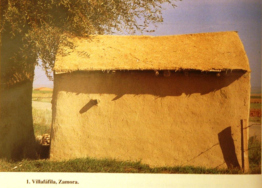


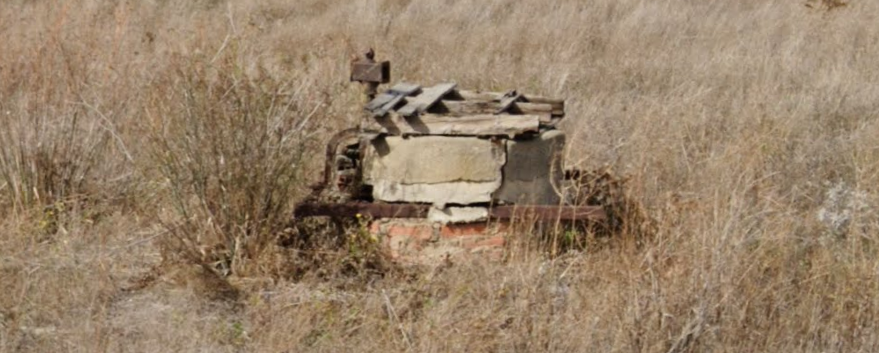
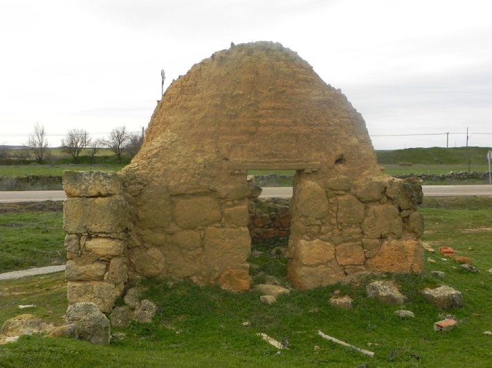
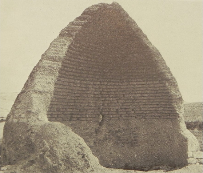
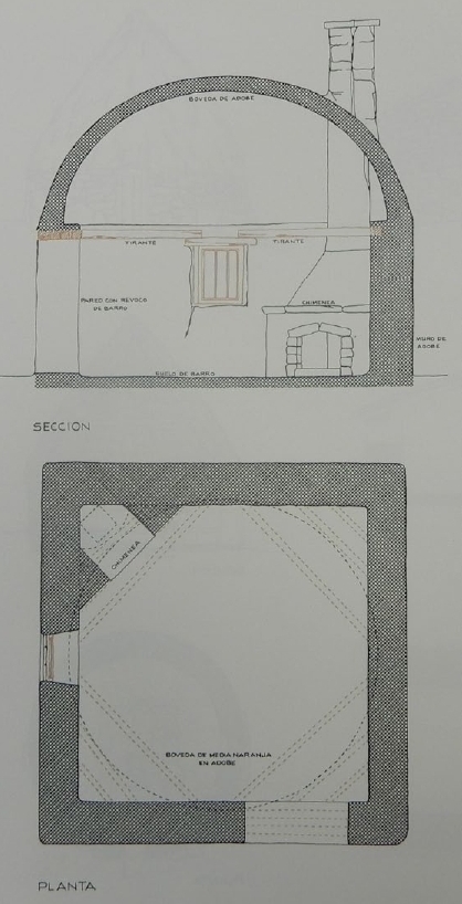
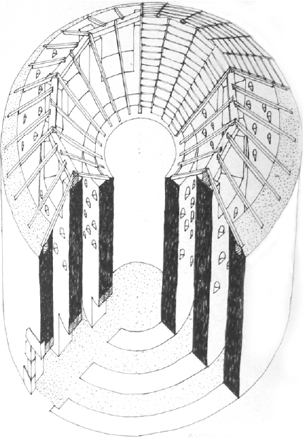
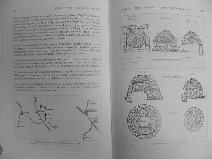

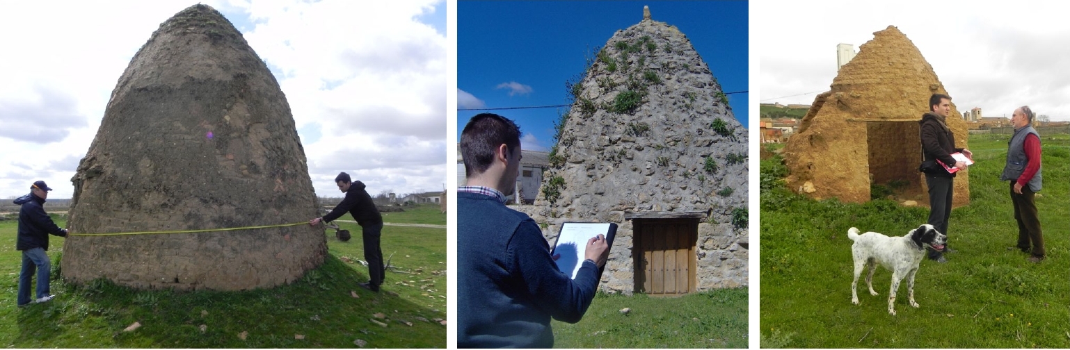
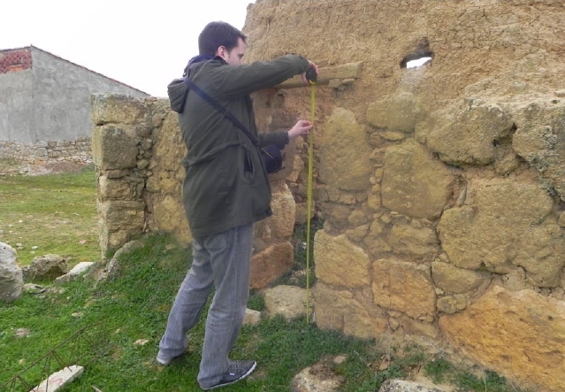
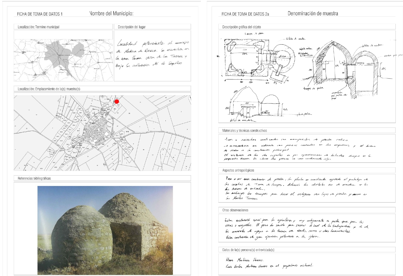
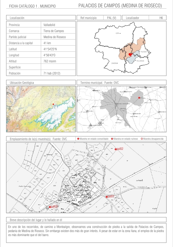
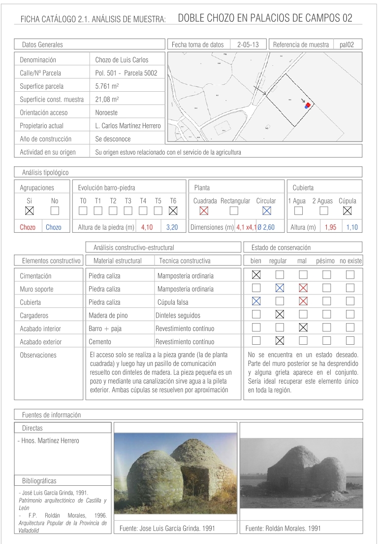
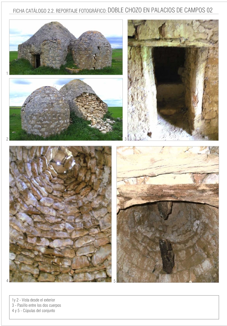
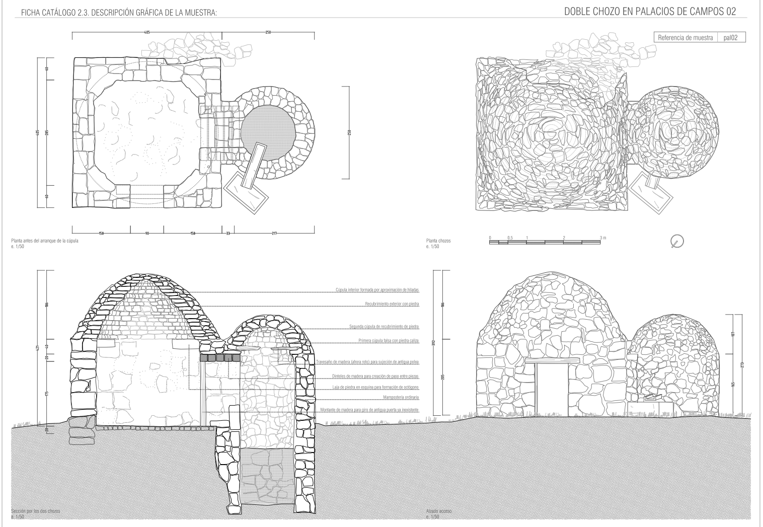
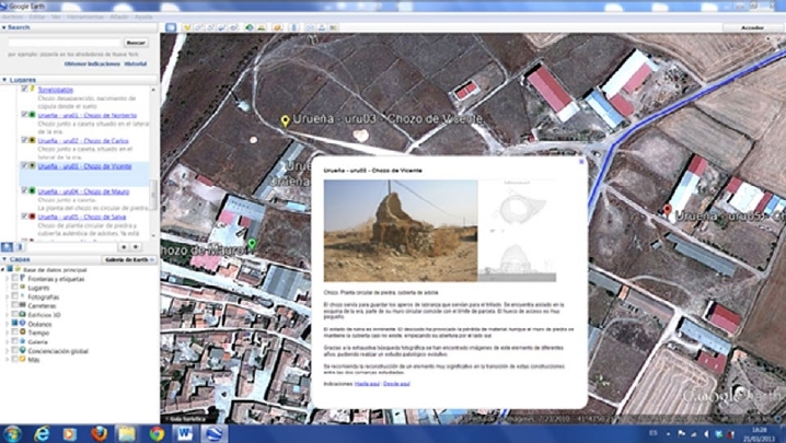
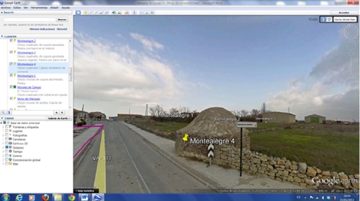


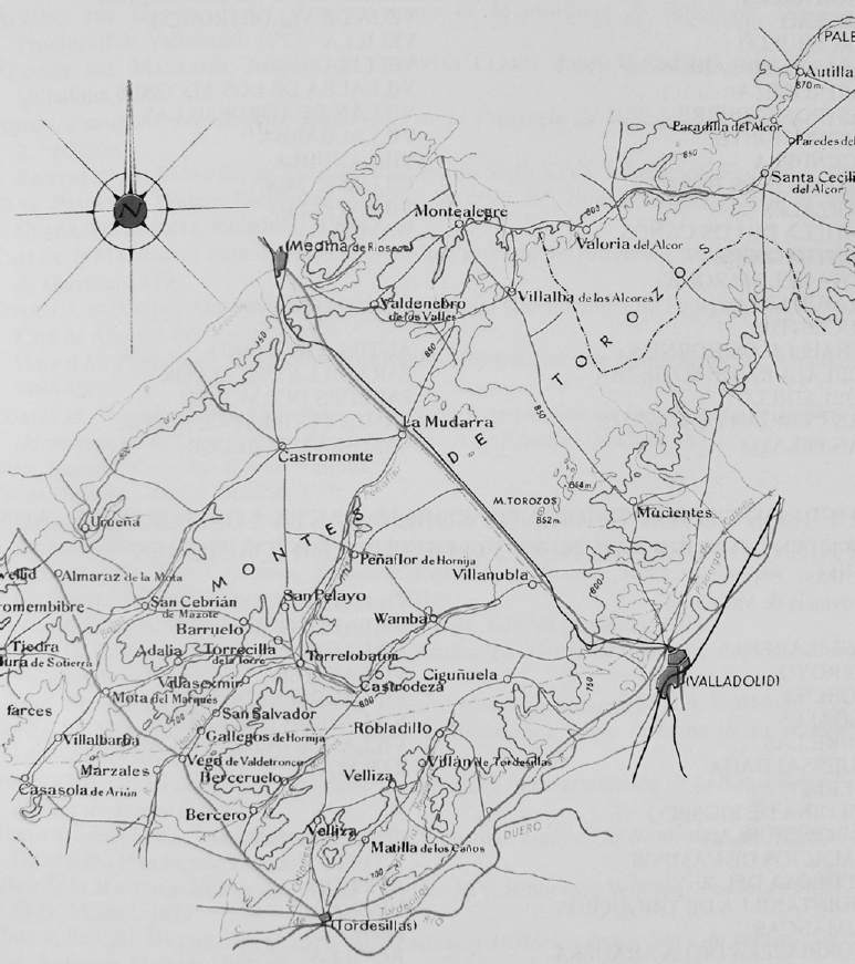
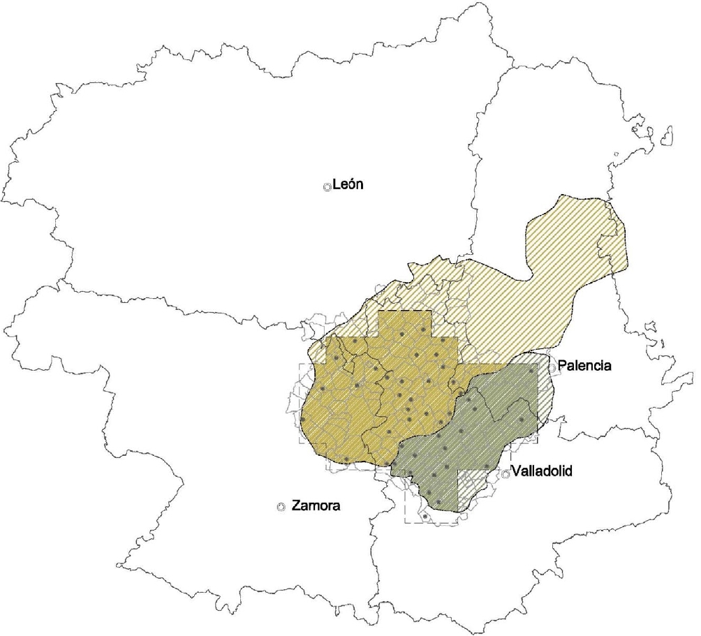
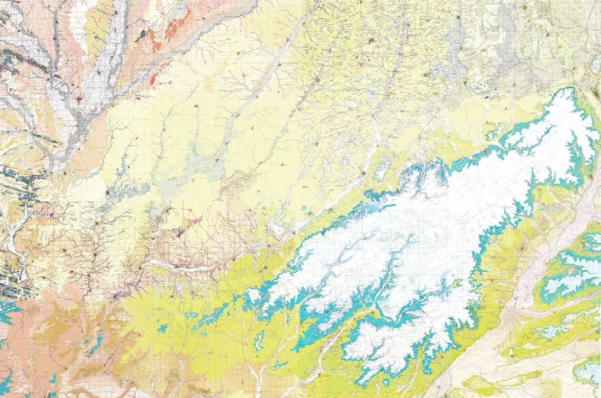
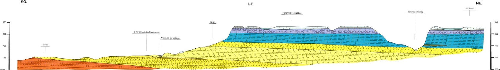
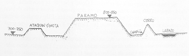
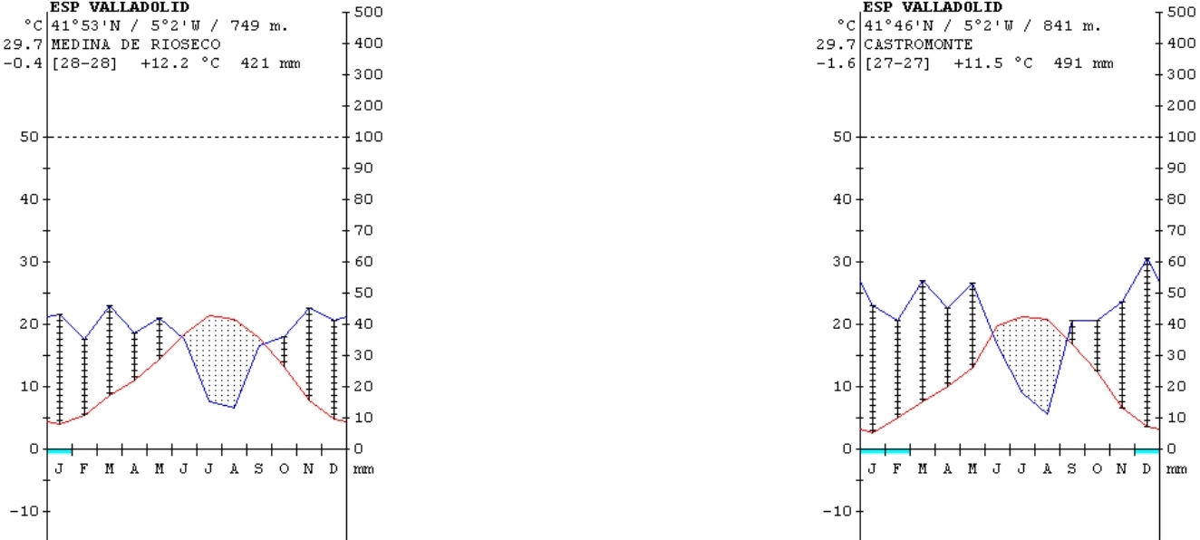

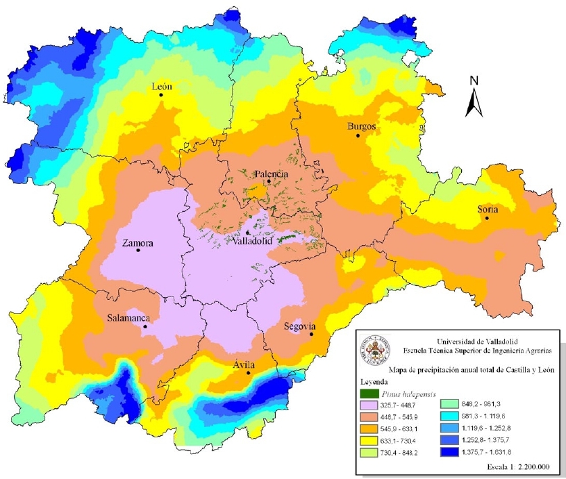
.jpg)

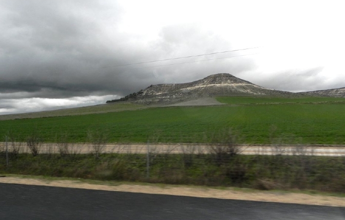
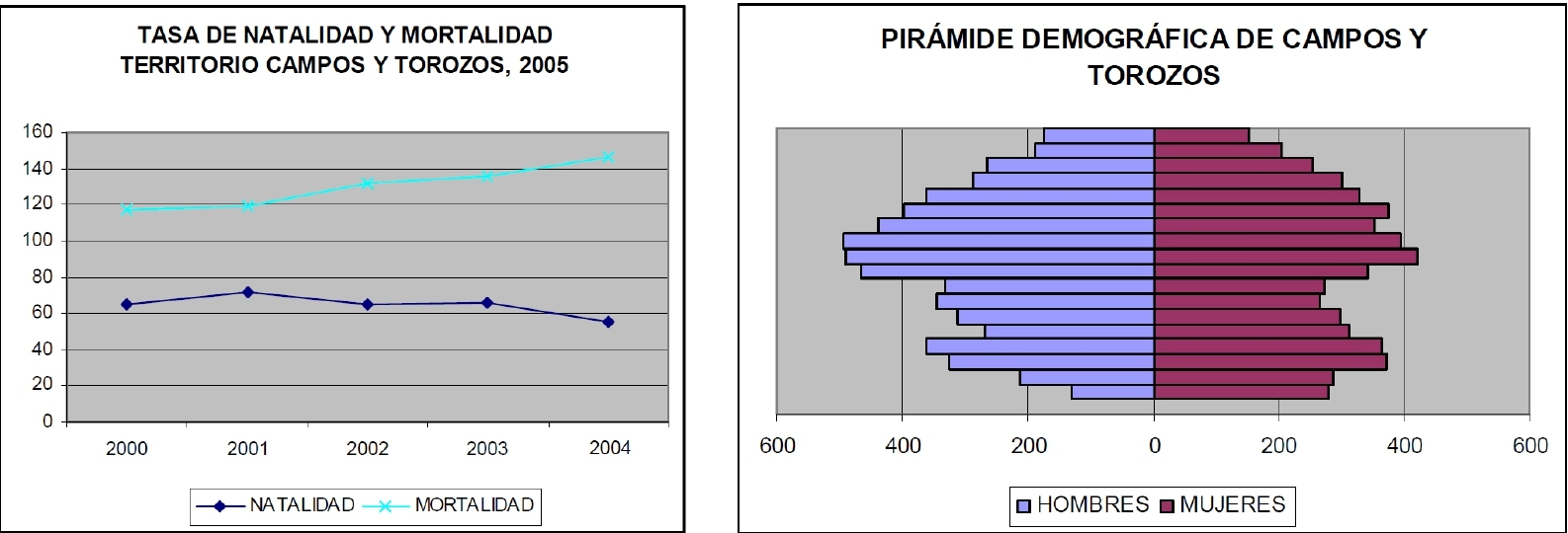
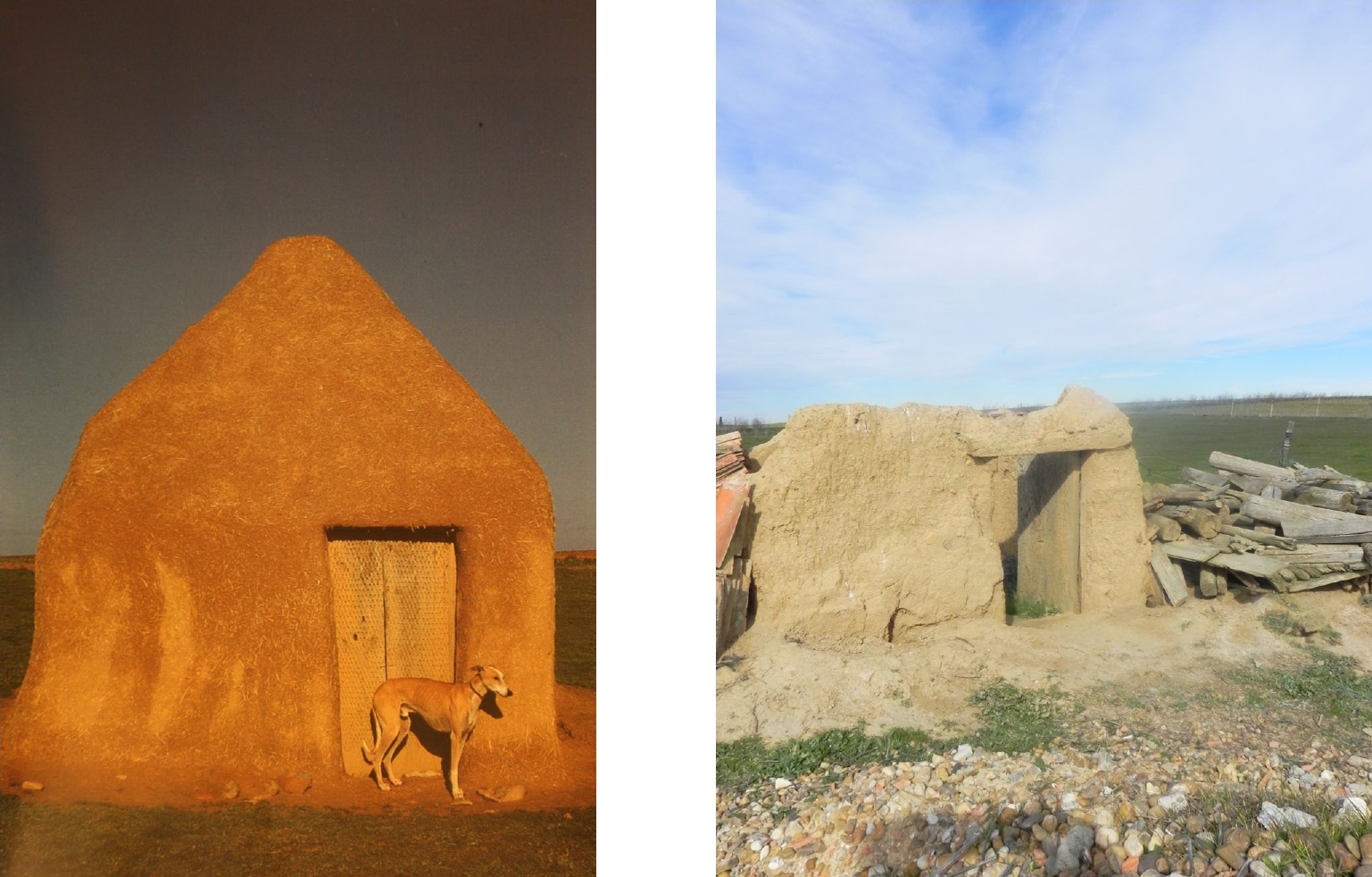
.jpg)
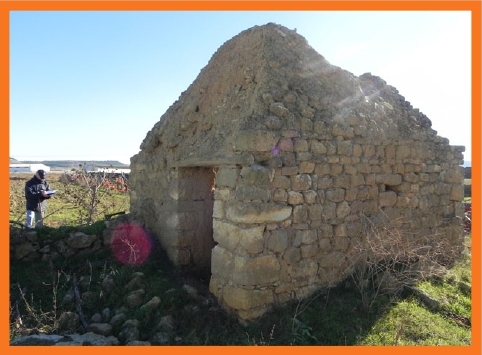
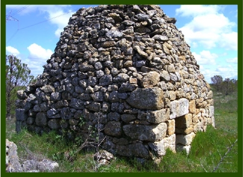


.jpg)
.jpg)
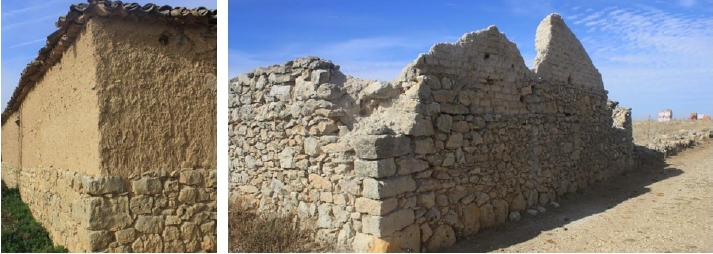
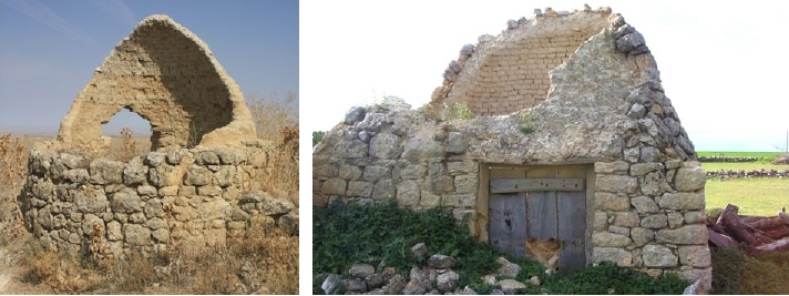
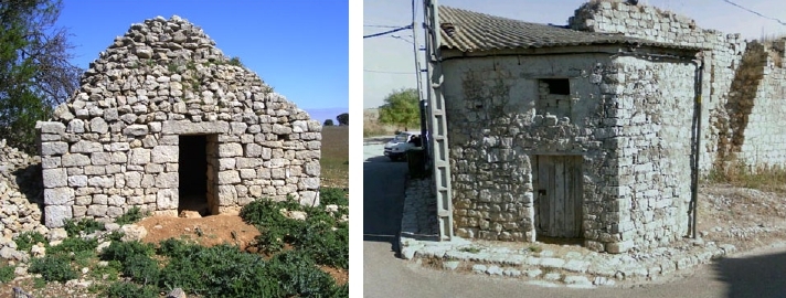
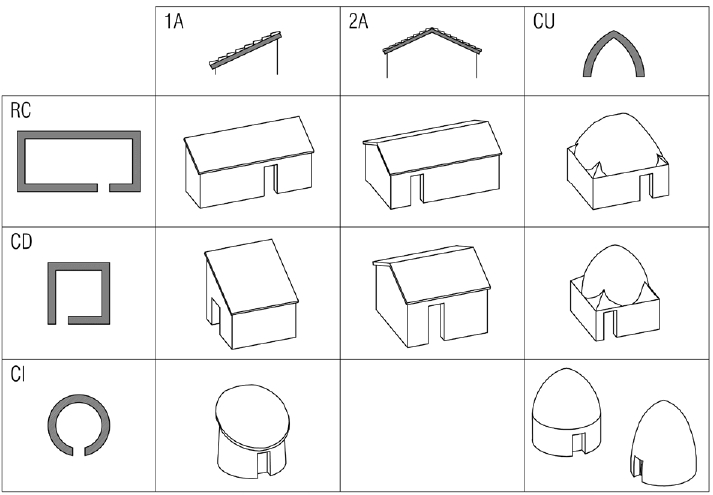
.jpg)
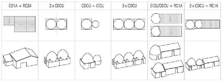
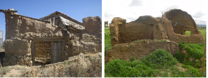
.jpg)
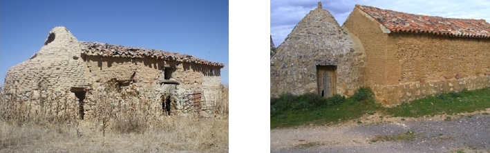
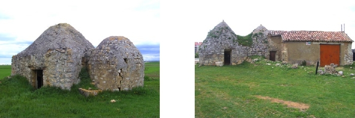


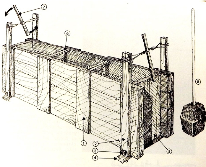
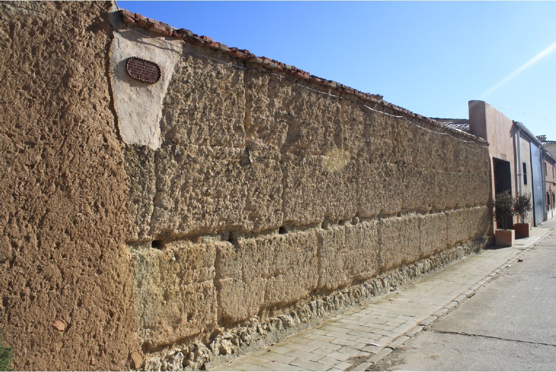
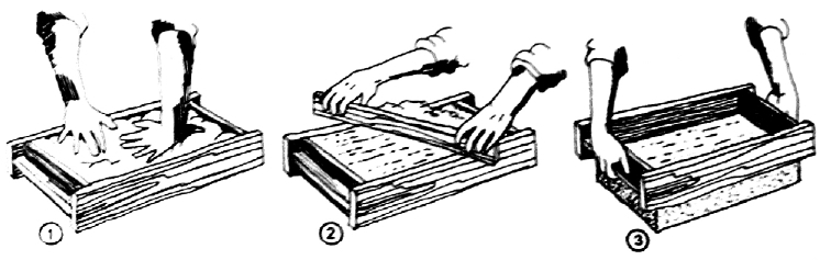
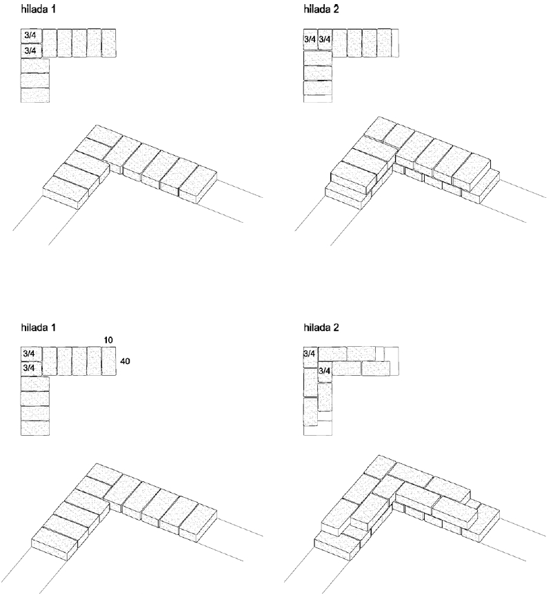
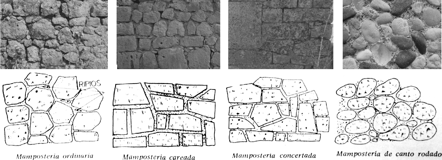
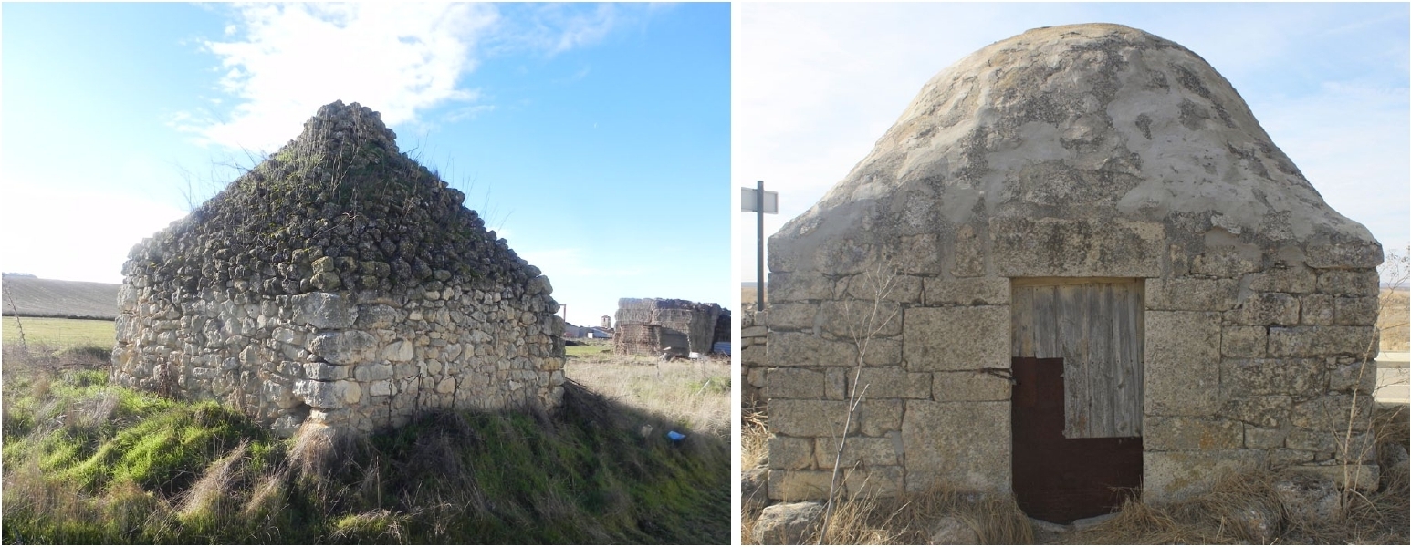
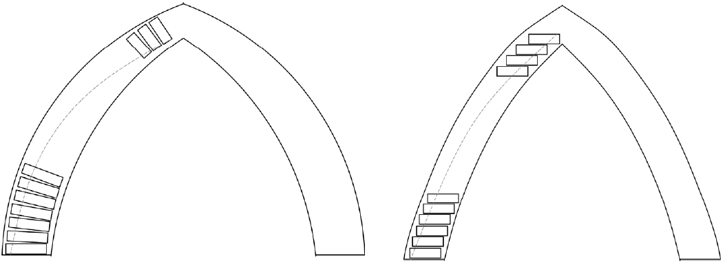
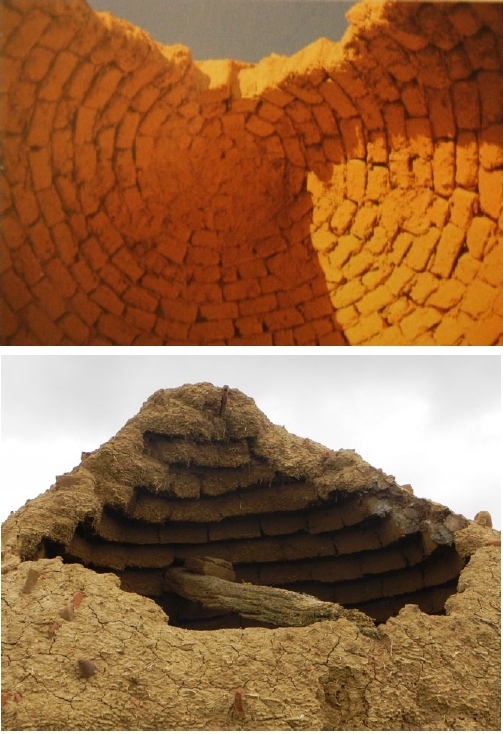
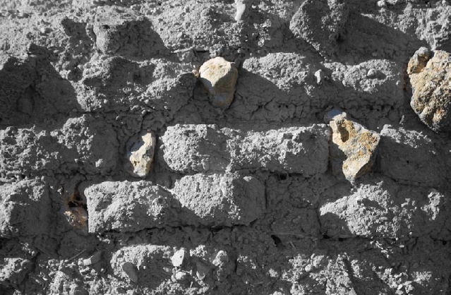
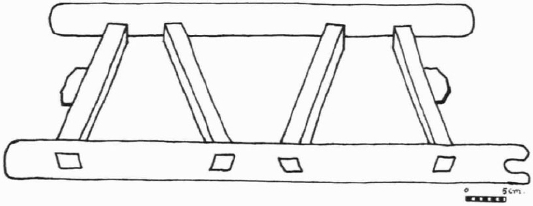
.jpg)
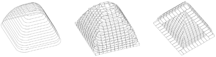
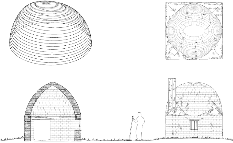
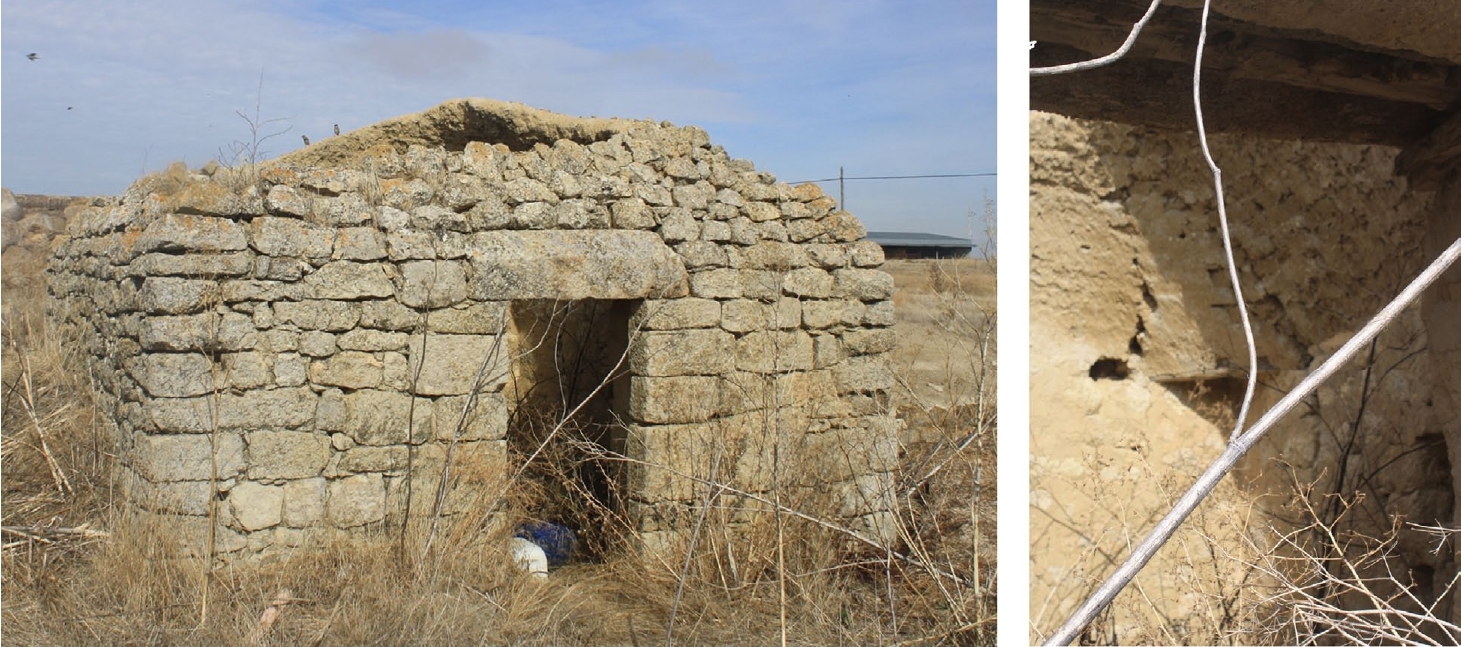
.jpg)
.jpg)
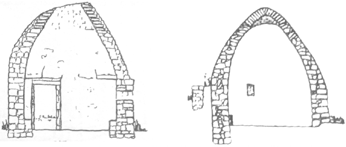
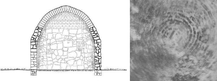
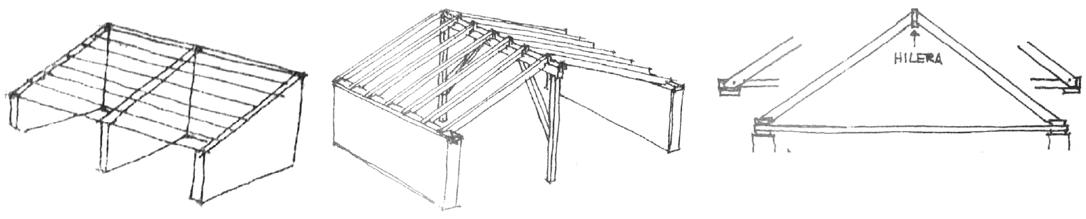
.jpg)
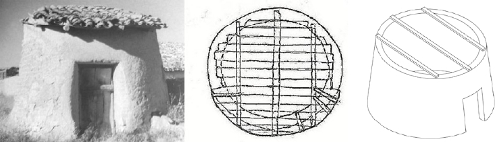
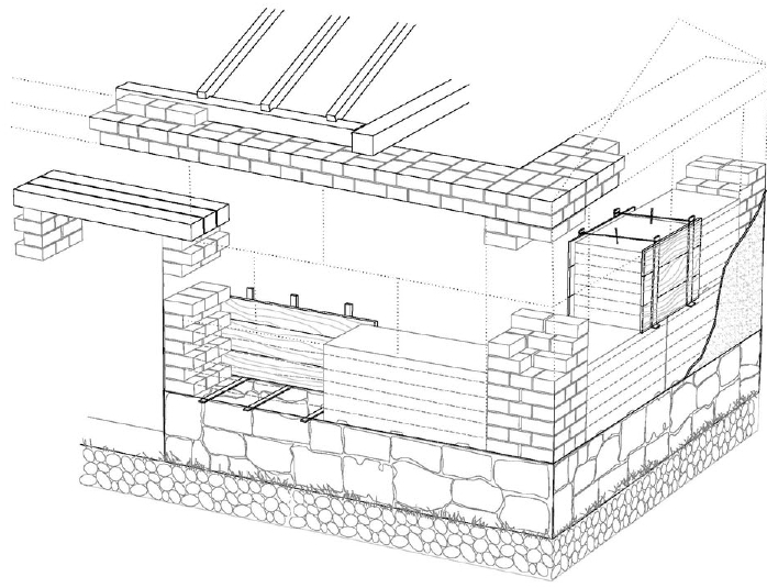
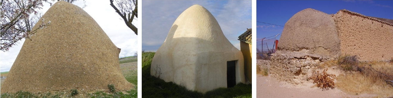
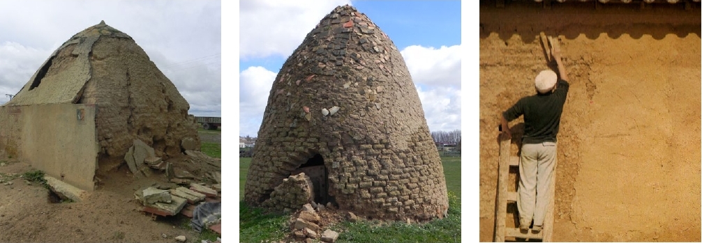
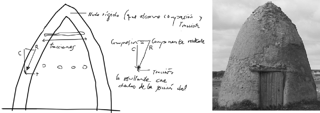
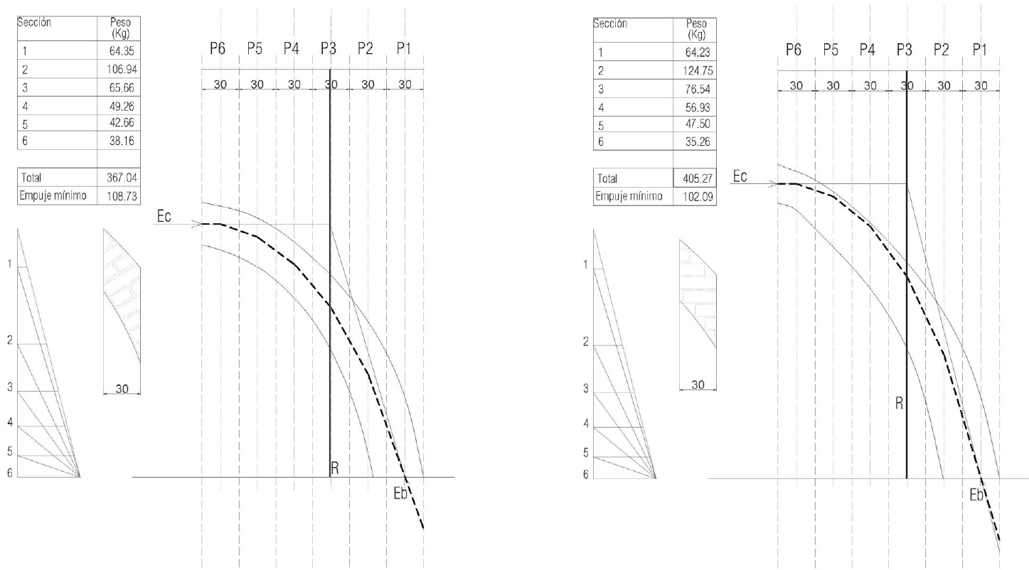
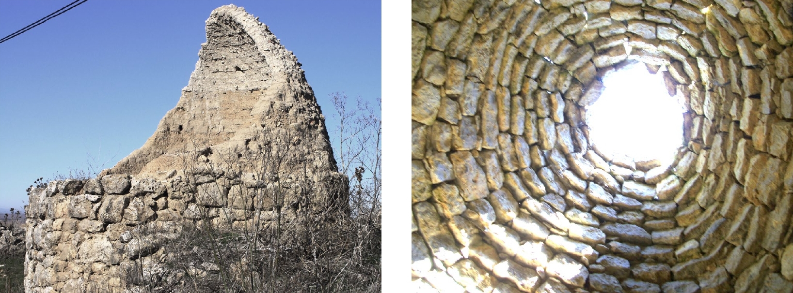
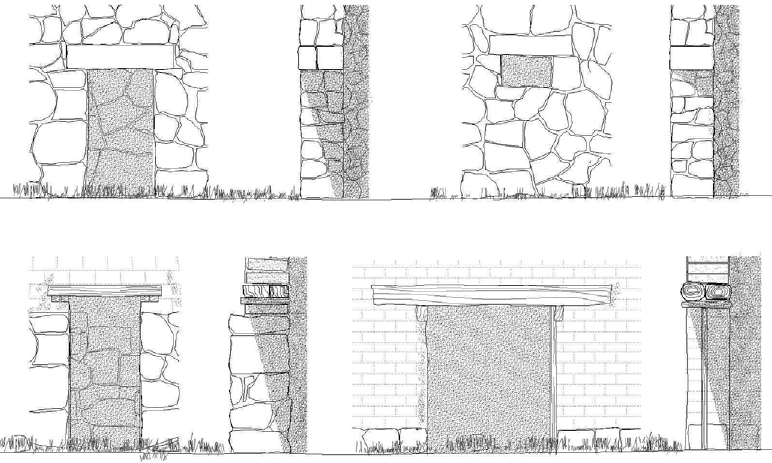
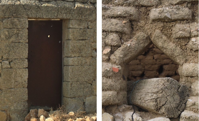
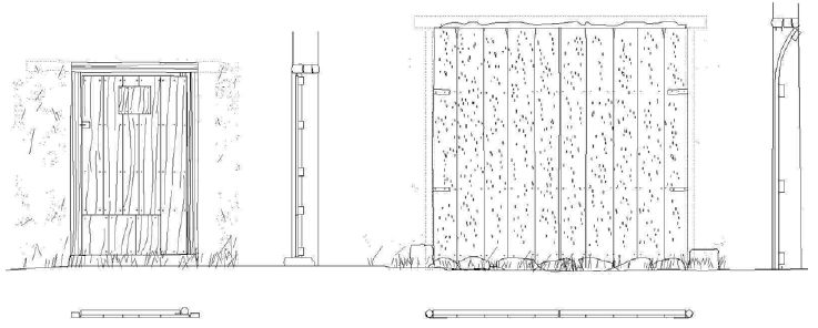
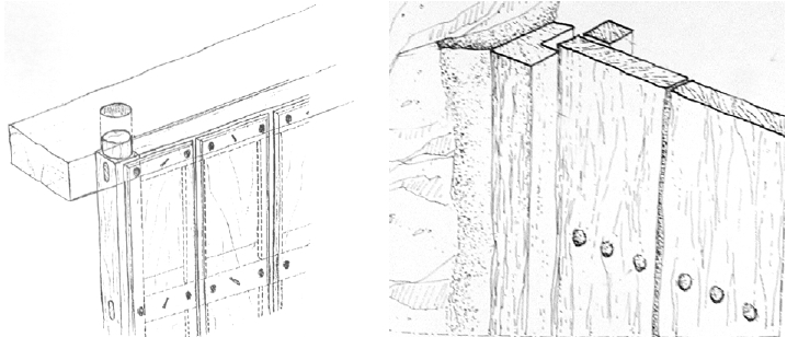
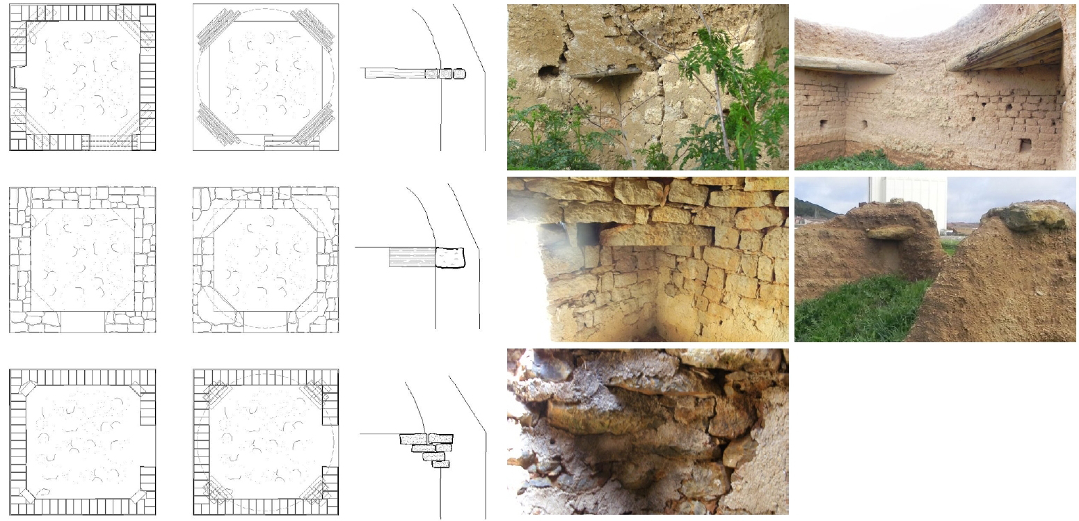
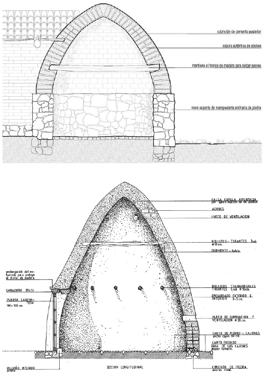
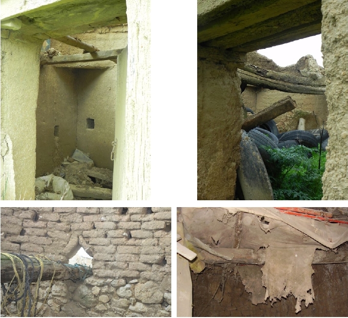
.jpg)
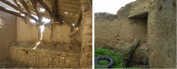
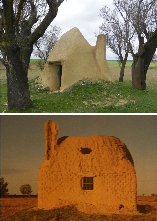
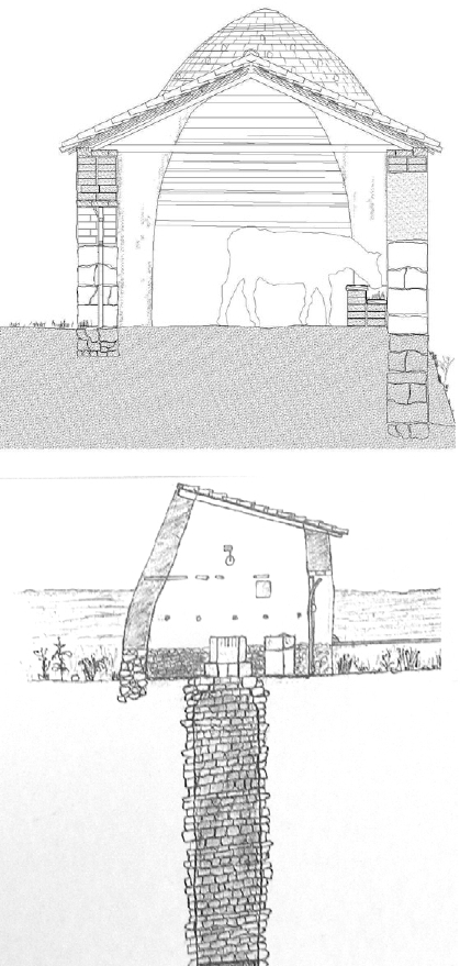
.jpg)
.jpg)
.jpg)
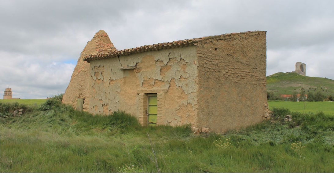
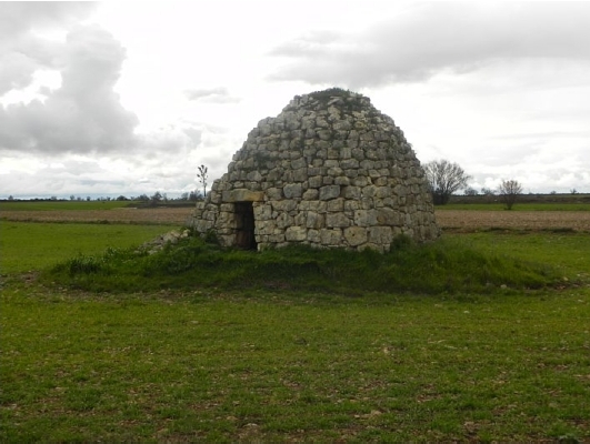
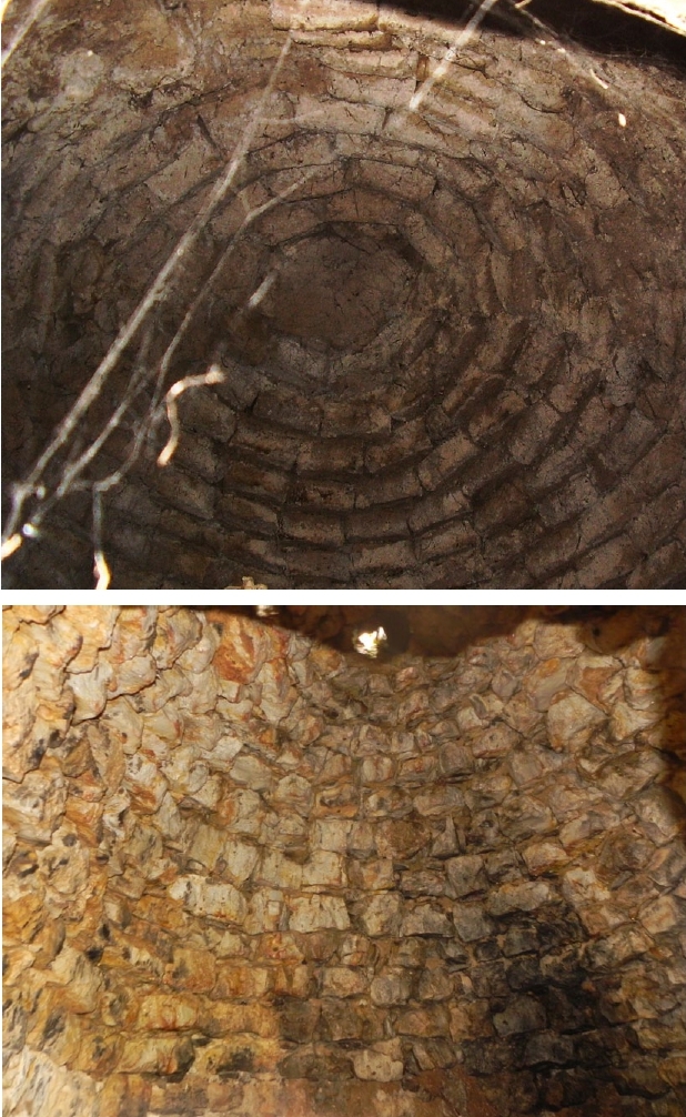

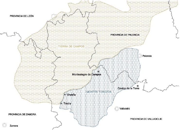
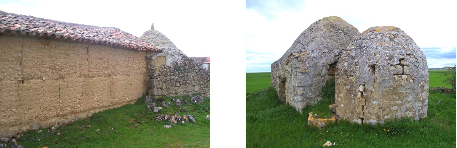
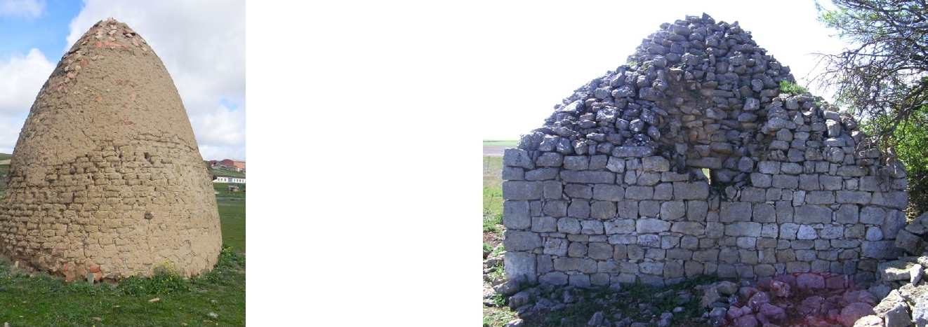
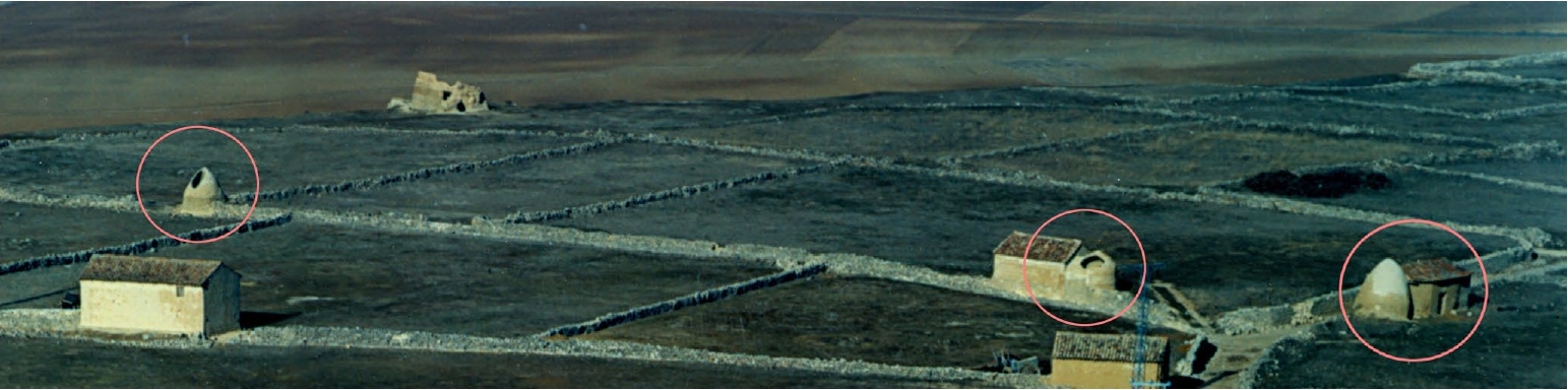
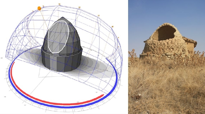
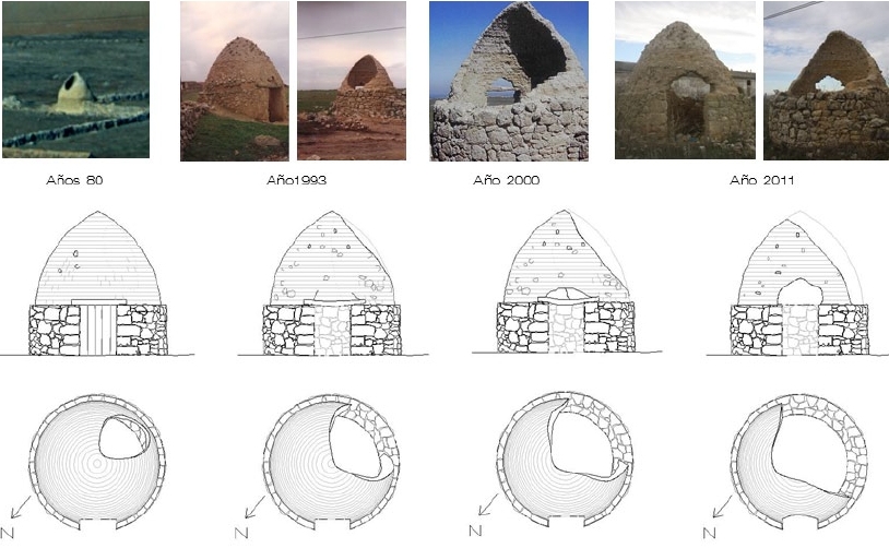
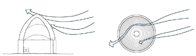
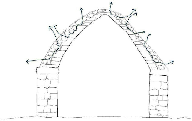
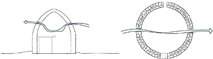
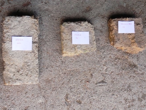
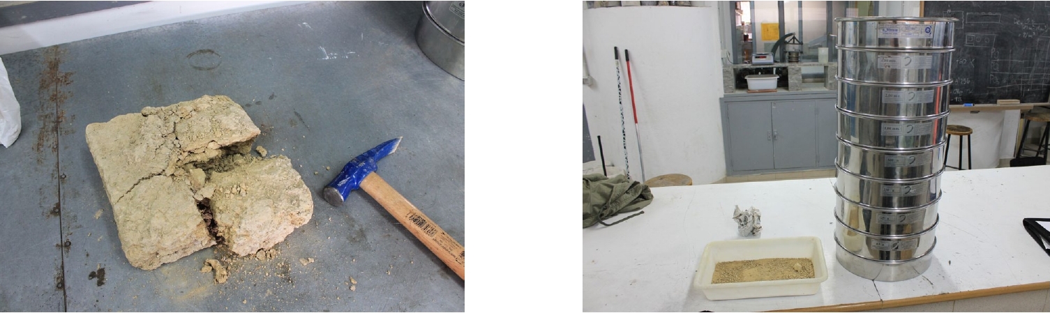
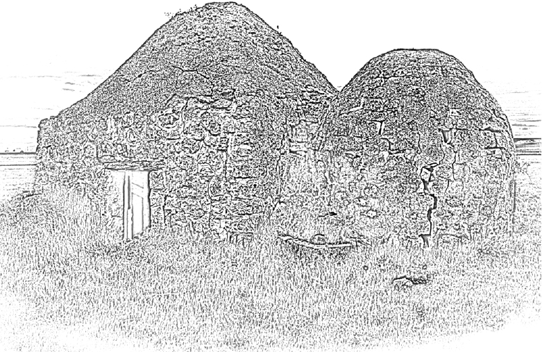


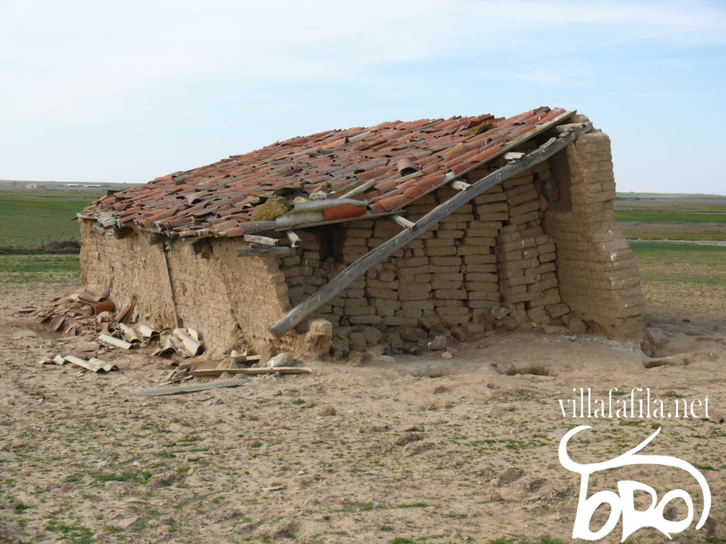


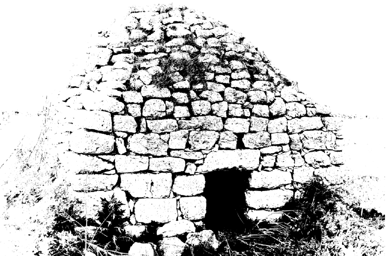


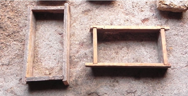

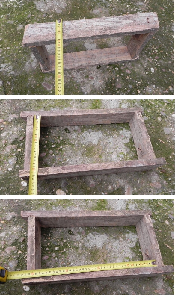
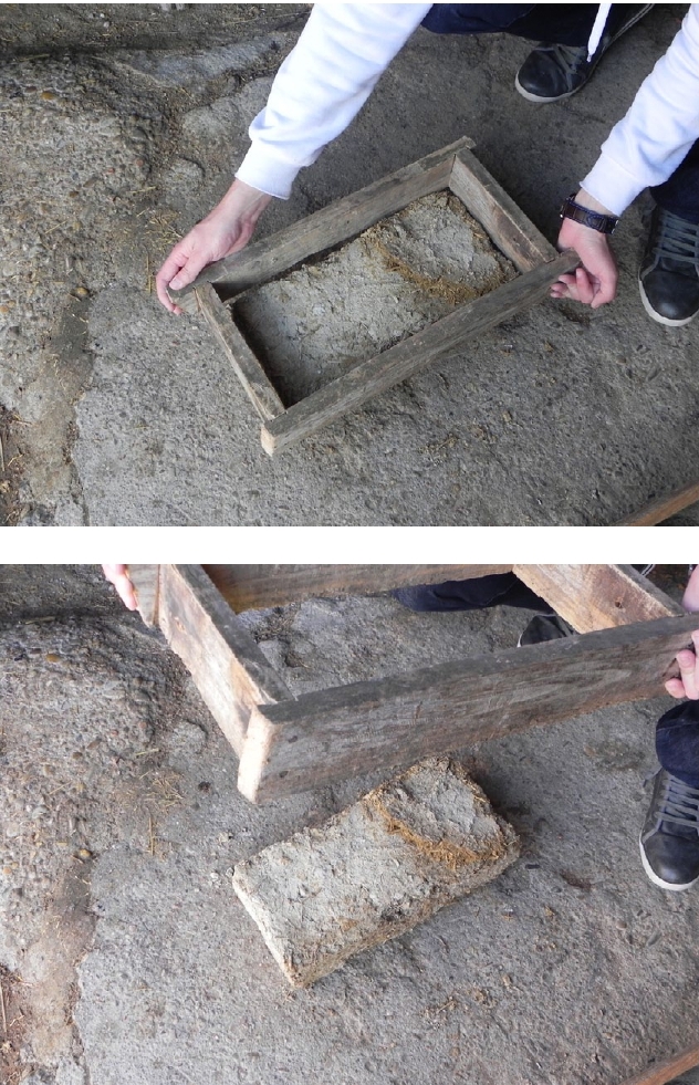
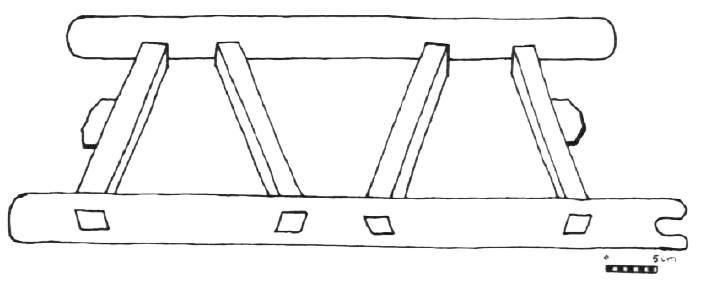
.jpg)
.jpg)
%20-%20copia.jpg)