MEDIEVAL EXPLOITATION OF SALINAS
OF VILLAFÁFILA
ITS INFLUENCE ON THE SETTLEMENT
AND SOCIETY
HISTORY OF THE SALT EXPLOITATIONS IN THE LAGOONS OF VILLAFÁFILA

|
MEDIEVAL EXPLOITATION OF SALINAS OF VILLAFÁFILA ITS INFLUENCE ON THE SETTLEMENT AND SOCIETY HISTORY OF THE SALT EXPLOITATIONS IN THE LAGOONS OF VILLAFÁFILA |
|
|
|
|
|
If during the Bronze Age the intensive benefit of the Salinas de Villafáfila is accredited, judging by the abundance of salt stations on the banks of the salt flats, it was during the Middle Ages, when the greatest splendor of the salt production of the region, favored by the relative isolation of the same with respect to the maritime or interior exploitations, verifying a great profusion of human settlements, some superimposed or close to the prehistoric ones, in the surroundings of the Lagoons, which have left abundant testimonies of their activity in medieval documentation,
The medieval exploitation of the salt mines is accredited from the beginning of the 10th century and persisted until the end of the Middle Ages, remaining residual until the middle of the 16th century and, probably, it was the main conditioning factor for the location and concentration of the medieval settlement of the region, whose characteristics should be known before describing the procedures and results of medieval salt exploitation.
THE MEDIEVAL SETTLEMENT OF THE REGION
Old road network.
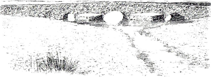
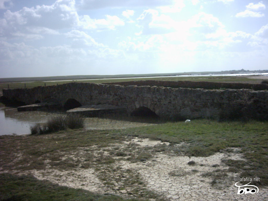
As for the old road network, on which these populations could have settled, and which could have served to give rise to the production of salt, there is little news. Known is the existence of a bridge of possible Roman origin and the remains of two roads in Villafáfila ( Martín Valls and Delibes, 1977 : 313 ) that seem to be heading, one towards the Roman settlement of the Fuente de San Pedro following the Vereda de Toro, and the other to the East, in the direction of Villalpando or Villárdiga (where the Roman sites of La Membrilla and Teso de los Ladrillos are documented), both converging on the bridge and continuing to the North in the direction of the Roman site of Valorio.
JM Bragado (1989), in his work on the Roman road network in Zamora, includes a secondary road that went through the Salado valley to the north and another branch that would join the Vía de la Plata with the road that followed the course of the Valderaduey passing near Villafáfila.
Documentary references from the 10th century seem to support these conjectures. We know of a "race" in the year 964 that went from Bretó de la Ribera (perhaps the old Roman mansion of Pretorium on the Vía de la Plata) to Valderaduey passing through Madronil, a salt mine located near the aforementioned Villarigo bridge, in the route between this and the Vereda de Toro "... ipsa Pautata que vocitant Matronille...iuxta Lacuna Maiore....IIIª part of the race that runs from Breto to Aratoi...". (Mínguez, 1978: doc. 223). This "...race that ran from Breto to Aratoi....”that passed through Madornil, had to cross the current town of Villafáfila and, probably, will be the one known as Carrerina, which has that direction and crosses the late Roman site of El Escambrón, to head towards the Villarigo bridge.
Another possible route, more or less perpendicular to the previous one, linked Castrogonzalo with Zamora passing through Villafáfila (Martínez Sopena, 1985: 104) or very close, and through the late Roman site of Los Villares, in San Agustín.
Apart from these two longer -distance or regional races or karrales , we find other roads mentioned in the 10th century that linked the nearby towns and that give us an idea of the early medieval road network that could have been superimposed on the Roman roads, at the time that indicates already existing places and, therefore, inhabited in those years.
Thus, we observe the existence of several lanes that connect various places with Lampreana. In addition to the aforementioned roads to Castrogonzalo and Zamora, communications with Revellinos are cited "...et per via qui discurrit de Revellinos ad Lampriana..." in 946, which was different from the one that linked Castrogonzalo with Lampreana to which called carrale maiore , probably because of its larger size.
A road connected Lampreana with the river Esla to the south of Bretó in 951, crossing the river on a ford or by boat, without ruling out the existence of a bridge at Quintos (Piélago de Juan Corua and Montenego), on whose limits it is cited, "...figet in Sancto Laurentio et usque in illa penna de Uecella...et figet in Carrera de Lampreana;...et de alia parte, Carrera que discurrit de Lampreana usque in Vecella .". This road in 1254 is cited as the Villafáfila race in a new delimitation of Montenegro: “it goes to the peak of the Casar Villafáfila race... and it passes to Sant Lorience de la Penna, just as it goes directly to the Penna de Veziela”, and may correspond to the road to Villa or Moynegro which, on the National Topographic Map, sheet 308, runs south of Bretó and Santovenia, in an east-west direction. At the end of the 15th century there was a path called Carrevillafáfila, a boat that crossed passengers, carts and walkers to the land of Távara, at the height of Quintos, as far as it went: “ the Villafáfila career path is a royal path, however now there is no walking since they removed the boat... and it is between the term of Quintos and Moreruela ”. The old Via de la Plata ran through this area in a perpendicular direction, north - south: " ...in oriente kale que discurrit a Zamora..." in Megretes(Las Maragatas, south of Bretó), year 971 (Mínguez 1976: doc. 264); in another document from 1182, referring to it, it is called "...carrera fossadera..." (Alfonso Antón 1986: doc. 25).
In the first half of the 10th century, other paths connected the village of Villa Traviesa with San Martín and with the Salina Grande , in the 930s : "...in Villa Travessa...there is a part that runs to Sancto Martino... " ., 934 : "...iuxta eclesia vestra de Sancto Martino in Lampreana, de eclesia usque in carrera..." , 937 : "...in termino de Villa Travessa...de IIIª parte carrera que discurrit a Lacuna Maiore..." (Mínguez, 1976: doc. 36); and Revellinos con Arcello year 946 : "...pro carrale que discurrit de Revellinos ad Arcello..." (Vignau, 1885: doc. CCXI).
In the twelfth century the "Vereda de Toro" appears several times as a reference path in certain delimitations. Thus in the demarcation of terms of Castrotorafe of 1129: "... as fer in Aradoy, et inde per Valderas, et inde á Oter daguila et enter the race of Toro , et inde per Valmaior, et inde á Santo Ioane demoledes, et inde a Breton..." (Cabezas Leflrer et a.. 1991: p. 219); in a donation of a vineyard: " which is on the way from Benavente to Toro" in 1197 (Reg. Martínez Sopena, 1985: doc. 786); in another donation of 1199: "illa terra iacet a la laguna de Monago.....et de altera parte cararia que discurrit a Toro..." (Vignau, 1885 :Doc. CXXII). This road was an alternative to the Vía de la Plata as it connected Astorga with Salamanca, through Toro. It is possible that before the founding of Benavente in the second half of the 12th century, the route of this road from Villafáfila continued a little further south, along the Espino road, an old cattle route, to cross the Esla by the Deustamben bridge. , between Villaveza and Miles.
It is also documented in 1152: "... sendeiru de latronibus.....duas uias que spartent se in exitu de uilla Moledes, unam que tendit ad Sanctum Tissum et alia que dudit ad Sanctum Petrum, et ad Sanctum Petrum dudit ad Sanctum Tissum." (Loscertales, 1976, II: doc. 48), all of them in the current term of Villarrín. From Bamba they left: "Carrera de Villalpando....Carrera de Cerecinos..." , in 1153 (Rodríguez González, 1966: doc. 23.), and Revellinos arrived: "...Carreira que discurrit de Villa Lobos ad ecclesiam of Revellinos..." , in 1155 (Vignau, 1885 doc.: LXXXVIII) .
Origins of medieval settlement.
The first documentary references to Lampreana date back to the year 917 and indicate that the salt mines were already being exploited at that time . That year, Abbot Iquila donated several goods to the convert Felicia and to the congregation of nuns of Santiago de León, including five paupers in Lampreana (Yánez Cifuentes, 1972: doc. 3).
It is difficult to know, following the traditional and conflicting theories about the depopulation of the Duero Valley, if these lands suffered complete abandonment after the Muslim invasion of the 8th century, or if small population groups persisted in them, dedicated to the exploitation of their haciendas and probably the salt mines.
Actualmente, cuando la hipótesis del vacío poblacional de la cuenca del Duero, defendida por D. Claudio Sánchez Albornoz, está superada, según algunos, y puesta en duda por otros estudiosos del medievo zamorano que se inclinan por suponer una persistencia de la población rural (Villar García., 1991 : 100-101), concluyendo que la despoblación de la cuenca del Duero fue sólo una retirada del personal militar y administrativo y de las gentes allegadas a ese personal (Maíllo Salgado, 1991 : 88-89 . "La población indígena seguiría sobre el territorio al margen de las operaciones militares lanzadas lejos de sus puntos de arranque por cristianos y musulmanes,... hasta que la situación cambie radicalmente a partir de Alfonso III" (Caballero Zoreda, 1995: 421) que organiza la repoblación de los territorios al norte del Duero a finales del siglo IX.
Based on this theoretical duplicity, there are certain elements that seem to support this continuity, not included in the written sources, in the settlement of Lampreana:
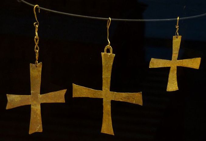
- The aforementioned coincidence of Roman and/or Visigothic remains with other early medieval remains in several sites, which has not yet been confirmed by archaeological excavation, since the excavation carried out in 1985 in the area where the Visigothic treasure was found did not had results that could give us an idea of the archaeological context of the find. Although they can be considered from the Visigoth period, the typology of the gold crosses and bronze pieces and their final use, better coincide with a date after 711, if the settlement resisted the alleged repopulation of the territory and the early medieval military incursions ( Knight Zoreda, 1995: 374).
- Some toponyms seem to have an ancient origin. In addition to the possible Visigothic etymology of Villafáfila (Lázaro Carreter, 1972), Villarigo (Solana Sáinz, 1985: 142), or Bamba; the population center of Moledes or Muélledes, between Villarrín and Villafáfila, can mean muladíes , a name by which Christians are known who, under Muslim domination, accepted the faith of Islam. Also in the place names Negrela (documented near Moledes), or Negraches in Revellinos, it has been wanted to see an ethnic reference to populations of North African origin (Cabero Domínguez, 1987: 63), although it is not yet possible to establish a toponymic relationship with the material findings. . The place name Maladones, village or term, documented in the Villarrín area in 996, may have an Arab origin, coming frommalá , which means salt pan in that language (Asín Palacios 1944), and may be indicating a population dedicated to the exploitation of the salt pans after the Muslim conquest.
- The citation of a hermitage and a villar near Revellinos in 946 "...et ermiario et ipsum villare qui est in termino de Veremundo..." , “...et ermiario sanct H..." ( that seem to correspond to the payment of Villares in the current district of San Agustín, where late Roman vestiges can be seen) may indicate remains of a pre-existing population, since the hermitages have always been the last vestige of an unpopulated area, as well as the mention of two churches already in 936 "eclesia vestra de Sancto Martino " (Mínguez, 1976: Doc. 39) in Lampreana, possibly in Otero, and 946 "pro eglesia Sancti Mametis" (Vignau 1885: Doc. CCXI), in Revellinos,where the high medieval capitals of these two towns could well come from (Gómez Moreno, 1927).
- There are other indications of the continuity of occupation of the space, such as the mention of vineyards grouped around Villa Travessa in the first half of the 10th century (Mínguez 1976: doc. 36), whose cultivation requires a continuity of population.
-But the main argument to defend the persistence of the population is the existence, since the beginning of the 10th century, of a totally organized exploitation of the salt flats with an infrastructure of wells, cisterns, beds..., which are not improvised in a short time, nor are the salt extraction techniques learned by a population recently arrived in the region, but rather they need a permanence in the territory and generational transmission of knowledge. In addition, the presence of abundant owners of salt mines whose farms border on others, indicate an intensive occupation of the environment a few years after the supposed repopulation.
- The analysis of the anthroponymy of these owners allows us to appreciate the existence of many names with clearly Visigothic resonances together with other Mozarabic or Latin names, which can give us an idea of the composition of its inhabitants as "a heterogeneous conglomerate of native peoples, Hispano-Visigoths, Arabs, Mozarabs and settlers" similar to the one existing in Sanabria in those years (Villar García, 1991: 103).
ONOMASTIC OF THE OWNERS OF LAMPREANA (930-937)
Abiza / Aboharon / Abolfarage / Alarigo / Almundar / Ambrino /Andemio / Atanarico /Auria Bicco / Cano / Coraisci / Donno / Emiliano / Fafila / Feles / Fredegundia / Fredinando / Gallecos / Gaudinas / Godesteo / Goino / Goldres / Gontilli / 2 Graciosa / Gudes / Guilliamon / Gundisalba / Ibenrez / Iubandus / Iuliano / Lallo / Lubla / Lupi (pbs.) / Luppi / María / Menendo / 3 Piniolo / Quildefonso / 2 Recemondo / Resinda / 2 Riquila / Sabarico / Sando / Segerico / Senda / Servanda / 2 Sesildi / Sesmiro / Sesnando / Sisegudo / Sisnando / Stefano / Teton.
Therefore, the origin of the early medieval population could have been threefold:
1-certain groups that would persist, dedicated, among other activities, to salt extraction, since the Visigoth period, some converted, due to unknown political circumstances, to Islam, and others conserving their religion. Perhaps, they were responsible for the concealment of the treasure of Villafáfila, or the use of the capitals of Otero and Revellinos. The existence of a North African population contribution in the s cannot be ruled out. VIII, especially in the area of Villarrín where place names with Islamic resonances such as Molledes, Maladones and Auterium de Ambrose are documented in the 10th century.
2 -the influx of Mozarabs from Al Ándalus in the last years of the s. IX is manifested in the written sources associated with the reconstruction of monasteries and of Zamora capital and in the existence of gentile toponyms such as Coreses, Merendeses or Toldanos (Villar García, 1991: 101). In our case, its presence in these lands stems from the mention of the village of Coreses in 936, possibly repopulated with people from Coria; from other toponyms such as Matronille , and from the anthroponymy of the 10th century [1] .
3 -the arrival of the population from the north, in family groups or from villages, which spontaneously or directed by leading people from the royal environment, incorporate these lands into the Asturian-Leonese monarchy, making them enter into its legal-administrative framework, and who acquire property through pressure, donations or purchases. The pressures are documented in 946 "...ipsa terra prendite de illorum parte..." in Revellinos (Vignau .1885: Doc. CCXI). In addition, well-known characters of the Leonese court of the 10th century, by the confirmations of the documents from the cathedral of León or from the monasteries of Sahagún or Eslonza, such as the abbot Iquila, Revel, the abbot Poficio, Piloti Gebuldi, Fortunio García, royal cubicle, the mayordomo Ansur and others, donate, buy or sell pausesand other properties in Lampreana.
Lampreana and its territory in the X-XII centuries
The lands surrounding the Villafáfila lagoons received the generic name of Lampreana during the 10th to 12th centuries. It has sometimes been alluded to, without documentary basis, that this name was due to the fact that the monks of Sahagún raised river lampreys (fish of the order of the cyclostomes, 30 or 40 cm long, that live in stagnant waters and in rivers of little current), in the lagoons of the area or in the ponds built for this purpose. But the toponym dates from before the monks of Sahagún began their acquisitions in the area (the first mention of the name is from 917 and the monks begin their work in 930), and at the beginning of the 10th century it is a name already consolidated. , so it could rather have its origin in the natural abundance of these lampreys in the lagoons since ancient times, without ruling out their commercial exploitation,
This term is used sometimes with the meaning of region, others as territory , and others as a town.
Following Martínez Sopena, it can be affirmed that during the 10th and 11th centuries in the Leonese kingdom there were jurisdictional territories that included several villages and that were designated with the name of a specially characterized nucleus, which exercised the central functions; most of the time this role was played by fortified hill forts, although there were cases of towns that played this central role. These nuclei were the headquarters from where the delegates of the power of the monarchy, the merinos, exercised their judicial functions.
The extension of these circumscriptions was imprecise, since their reconstruction must be done in view of very partial data, and changed by the concessions of immunity, which the king makes for the benefit of individuals, of some of the towns or villages included in these territories ( Martinez Sopena, 1985).
This imprecision and instability in the territorial delimitation is not particular only to the region of Tierra de Campos, but also in the rest of the province of Zamora one can "venture the existence of changing administrative areas, and scarcely rooted, in which Some population centers are taken as a situational reference" (Villar García, 1991: 104).
In the case that concerns me, it can be stated that there was a large territory called Lampreana or Lamprean territory , which included several villages or towns (in the sense of the 10th and 11th centuries, synonymous with the populated nucleus of any legal entity). The first mention of the territory as such dates back to the year 945, although the towns of San Martín and Villatraviesa “in Lampreana ” have been mentioned since 930, although the forged document from 922 generically mentions several towns included: “in Lampreana... de totas ipsas uillas ”. [two]
By the location of the villages included in Lampreana we can make a more or less approximate delimitation of the territory, which was different from Campo de Toro, Zamora and Campos. Thus in 1049: "...Fredenando Monniz tenente Campo de Tauro et Zamora...in uillulis eiesdem loci et amplius in Lampreana...., uel in omnes uillas de Lampredana, seu de Campos..." In 1106, in a list of estates of the cathedral of León, the estates of the different territories are cited separately: "in Campo de Tauro.....; in terra of Zamora....; in Terra de Lampredana... ” (Herrero, 1988 Docs: 535 and 1137).
It occupied the current municipalities of Revellinos, San Agustín del Pozo, Villafáfila with Otero de Sariegos, Villarrín de Campos, part of Tapioles (Bamba) and a large part of Manganeses (Junciel,...), although it is very possible that its extension was extended to the south and southwest, including in 1042 "Rego de Lampriana" (Alfonso Antón, 1986, doc.: 1), which was different from "Rego Severi, qui est in territory Ad Torabe prope monasterium Morairiola" (Ruiz Asensio, 1989, doc.: 970), but the documentation of the time that I have handled does not allow us to specify it. From the north we know that Vidayanes was not included, at least in the first half of the 12th century: in 1139 Alfonso VII donated half of Vidagenos which is between Castro Gonzalo and La Lamprea(Fernández Duro. 1882: 335).
The existence of a royal merino in Lampreana in the year 1042 is known: "...Vita Didaz maiorinus regis in Lampreana..." (Alfonso Antón. 1986: Doc.1), who would exercise the delegated power of the king for the administration of the territory, both at the patrimonial and jurisdictional level. His headquarters must have been located at the head of the territory, in the town of Lampreana.
The existence of this town can be known by various indirect references from the 10th century, such as:
- the mentions of carrales that start from or go to Lampreana, and that normally, in other cases of mention of roads and paths, are directed to a specific urban nucleus, thus from Revellinos in Lampreana territory a road is directed to Lampreana (Vignau 1885 : doc CCXI)
- In the confirmations of documents for the purchase of estates by the monastery of Sahagún in Bretó and in Villaveza, "Zacarias abidante in Lampreana" is cited in 971, and "frate Belite in Lampreana avitante" in 980 (Mínguez Fernández ,1976: docs 264 and 302).
- in 1025 a "super Lampreana" vineyard is cited (Ruiz Asensio, 1987: Doc. 943).
However, the most precise reference to the town of that name is in the document of the donation of the tithe of salt toll by Alfonso VI to the canons of the cathedral of León in 1073: "illis donatiuum quod non habebant de redditu mei salis quod antecessores mei possederunt in uilla que dicitur Lampreana.... adimus unum hominem quem dicimus excusetum in ipsa uilla de nostro regali ,...cum suo solare et sua hereditate ... " (Ruiz Asensio, 1989: Doc. 1185) . This is why we know of the existence of such a town, that it had salt flats and that it was royal and that its inhabitants, together with their houses and estates, were vassals of the king.
About the exact location of this town we can have an approximation by the following data: it must have been to the south of Revellinos because in the year 946 two roads are mentioned, one from Castrogonzalo to Lampreana, which runs near Revellinos, and another different one that goes from Revellinos to Lampreana. It would also have to be found to the north of the village of Coreses (unpopulated located about two kilometers south of Villafáfila), since in the year 936, in reference to the limits of a pause , a road was cited that ran to Zamora from Lampreana.
Apart from these very few and imprecise references, from the twelfth century an equivalence or similarity between the terms Villafáfila = Lampreana is observed in the documentation, being, sometimes, used as synonyms, and gradually substituting the Lampreana denomination for that of Villafáfila when It refers to the whole of the salt mines or to villages in the territory; or in the performance of the central political functions of the region, even before the organization of Villafáfila as a royal town.
Therefore, it can be affirmed that the town of Lampreana must have corresponded to the current Villafáfila or be very close to it, in one of the settlements to the south of it, near the Salina Grande, since in the 18th century in that area the minor toponym of La Lampreana was located: "in the terms of Villafáfila in the place called Cureses and La Lampreana two springs half a league from Villafáfila, half from Villarrín and a quarter of a league from Otero" (AGS Direc. Gen. de Rentas 1st Consignment No. 2355) [3]. Starting in the 12th century, Villafáfila assumed the functions previously carried out by it, as occurred in other places in Tierra de Campos, such as the town of Mayorga, which, after its foundation as a royal town, replaced the nearby Castrofroila as head of the surrounding territory, which It had been in the eleventh century.
To support this equivalence we must take into account certain data:
- In the delimitation of Montenegro, property of the Sahagún monastery, near Esla, between Santovenia and Bretó, in 951 a series of geographical elements are cited, among others "Lampreana race" (Fernández Flórez, 1990: Doc. 1170). In 1254, in another document that alludes to the same Montenegro, the delimitation is made with the same geographic accidents, but Lampreana race is no longer named, but Villafáfila race (Alfonso Antón, 1986: doc. 132), which corresponds to the same road.
- Regarding the donation of Alfonso VI to the cathedral of León in 1073 mentioned above, he grants it, among other things, " reditu meis salis in villa que dicitur Lampreana" , and by another document from the 13th century, c.1240, on rents that belong to the cathedral of León we are told: "de salinis de Villa Fafila, redditus quatuor annorum..." (Ruiz Asensio, 1989: doc. 2032), that due to the terminology there seems to be a correspondence between both rents, with the consequent equivalences of names evolved over time.
- Villafáfila is cited in the year 936 between the limits of a pause in Lampreana : "Iª pause ad Lacuna Maiore ad terminum de Abiza et de Pinniolo et de Villa de Fafila" which indicates that at this time Villafáfila was very close to the Salina Grande; in 954 it is mentioned "in Lampreana in Villafafila Palacios obtimos cum suas hereditates",which seems to indicate a certain degree of urban development, and with the name of Villafáfila it is not mentioned again until the middle of the 12th century. It is in those two centuries of silence that the town of Lampreana and its Merino are documented. As of 1143, Villafáfila is cited in Lampreana territory and its merinos appear in the dates and confirmations of the documents referring both to Villafáfila itself and to Revellinos, Requejo, Bamba, and whenever they refer to the territory of Lampreana unspecifically, even as late as 1200: "... damus totam nostram salinam quantam nos habemus in the territory of Lampreana, et bolonera quod nos habemus in flumen que uocitant Esla...".The date of this document mentions the king and queen, the king's butler, and the tenente, merino and mayors of Villafáfila (Cabero, 1987: doc. III).
-In 1154 [4] Alfonso VII donates to the cathedral of Astorga the third of the tithes of "tota terra Lampreana et de Villafafila ", reiteration that seems to indicate, either a pre-eminence of the second within the territory of Lampreana (which includes according to documentation in 1148, 1153, 1155, 1177), or, perhaps, its equivalence. In addition, the geographical scope of the expression "tota terra Lampreana"it is restricted to the territory included in the diocese of Astorga, that is, from Revellinos in the north to Villarrín in the south, leaving out what is currently known by the nickname of Lampreana, which at that time belonged to the diocese of Zamora. Moreover, even Villarrín, who was always part of the original Lampreana, seems to not include this donation, since his thirds were donated to the bishop of Astorga by the infanta Elvira in 1155 [5] .
- In 1165 reference is made to "omnibus morantibus in Lampreana et in Uillafafila quod ecclesie sancti Jacobi qui est in eadem uilla..." (Vignau, 1885: doc. XCIII), and still in a document from 1228 that relates the properties of the church of Astorga is said "In Villa fafila et in Lampreana, ecclesiam Sancti Ioanis cum pertinenciis suis et vineas et hereditatem et tercias ad cellarium episcopi pertinent" (ADA Cámara Episcopal, perg. 2/40. Published by Cabero, 1987: 45) , which is a clear example of reiteration and equivalence of both entities.
In summary, during the 10th and 11th centuries there was a territory known as Lampreana, whose center was the town of the same name located in or near the current Villafáfila, to the south of it in the vicinity of Salina Grande. During the 12th century, a new delimitation based on "Royal Villas" emerged, as we will see later, which in many cases inherited the old territorial demarcation and in others, as is the case of Villafáfila, its alfoz was smaller. The location of the new towns was made taking advantage of old settlements or looking for more suitable nearby ones, and their name sometimes underwent variations (Benavente was first called Malgrat, or Aguilar de Campos was called Castromayor,...). In this case, for more than a century the new territory continued to be called Lampreana or Villafáfila indistinctly, especially from the Leonese perspective (bishopric of Astorga, Leonese monasteries and royal chancery); this area of reference was included in the diocese of Astorga.
The towns that are currently known by the nickname of Lampreana (Manganeses, Pajares and Villalba), at this time are cited without that name, which they incorporate in the late Middle Ages, when it has ceased to be used to refer to Villafáfila [6] . It is possible that they were called that, either because they previously belonged to the territory of Lampreana, or because, from Zamora's point of view, this region bordering Astorga began to be called Lampreana due to its proximity or lack of definition of limits, since at this time lawsuits of interference arise between bishoprics due to the lack of precision in the delimitation of the dioceses. [7]
Forms of settlement in the X-XI centuries
The predominant form of settlement throughout the Tierra de Campos, at this time, is the village often called a villa; These are groups or communities of neighbors made up of one or several families and their descendants, who, around the populated nucleus, organize a territory up to the limit of other nearby villages (Villar García, 1991).
These territories are fragmented into places of habitation, land, curtains, herreñales, etc., connected to each other by an extensive network of paths and trails and their inhabitants are dedicated to the exploitation of individual or collective properties in the territory. Regarding collective property, we have the example of 962, which when citing the limits of a land next to the salt flats, mentions: "a parte occidentali termini de homines de Villa Abtracies..." (Mínguez Fernández. 1976. Doc. 196) .
The dispersed settlement is less significant and throughout the Tierra de Campos it tends to disappear over the centuries due to abandonment or to give rise to a village due to the permanence of the descendants of a former owner. In the area studied we have some specific news of this type of dispersed settlement. Thus, in 945, near Revellinos "ipsos kasares " are documented , and in 946 "in locum predictum iusta uilla que uocitant Revellinos... ipsum villares qui est in termino de Veremundo... cum meas kasas et ipsas cortes et ipsos ortos cum your whores"(Vignau, 1885: doc. CCX and CCXI). In the current minor toponymy there are several payments in the area with this appellation: one, in San Agustín (which is the one previously mentioned, since in 1751 that monastery still had two lands there, where the Roman remains currently appear); another payment known as "El Villar" exists in Villafáfila, near the Villarigo bridge, with abundant medieval ceramic remains; and a third payment of "Los Villares" is in Villarrín de Campos, which must correspond to "...Uillaribus que sunt inter Sanctum Tyrsum et Moledes..."over whose property the monks of Sobrado and the master of Santiago disputed in 1186 (Loscertales, 1976 II: doc. 45), and El Villar, on the outskirts of the current town, on the edge of Salado. Some of these villares could have given rise to villages, as may have been the case of Villar de Santa Olaya, as will be seen later. The existence of this scattered settlement can also be deduced from the abundance of places with medieval ceramic remains dating from the 11th century, which seem not to form village groups, due to their small size and because they do not coincide with the mentions of towns or villages of the sources, but that could well correspond to the cabins, which were a set of buildings for the exploitation of salt and dwelling places, at least seasonally, for the workers, located around the lagoons.
The villages used to organize their ties around a parish or church forming "collatios" or collations, which are mentioned in nearby places. Thus, in 971, in the purchase of a mountain by Sahagún in Villaveza, he confirms "collatio Sancti Emiliani" (Mínguez, 1976. Doc. 264).
The urban space was not homogeneous, the houses, orchards or barns alternated with paths : "... Iª corte cum III casa et sua terra conclusa et una ferragine iuxta eclesia vestra de Sancto Martino in Lampreana, de eclesia usque in carrera... " in the year 934 (Mínguez 1976 Doc. 36). It seems that the court [8] is the material base of a property made up of one or more houses together with another farm or other type of farm. It is mentioned numerous times in medieval documentation: in addition to the one cited above, in 946, in Revellinos "...meas terras....cum meas kasas et ipsas cortes et ipsos ortos..." (Vignau, 1885: doc. CCXI), in 979 the monastery of Santa Marta received the court of Ordoño (Quintana, 1991); in Villafáfila in the year 1148, "... a court ad cimiterio sancte Marie"; in 1155 "...a court cum quatuor paused…" in 1151 "...in Reuellinos a court cum suas terras ..." (Vignau, 1885: doc. LXXIX, LXXXI, LXXXVII);"...in illa Cortina de Bamba, tam uineas quam perales..." (Rodríguez González, 1966: doc. 33); in 1179 "in Moledes a media court cum suo casal of him" (Loscertales, 1976 II: doc. 265).
In the region that surrounds the Villafáfila lagoons, at least 10 villages can be documented in the 10th century, another 9 in the 11th century, in addition to another 13 in the 12th century, whose existence seems to be earlier, which gives a high population concentration, especially in the vicinity of the lagoons, whose reason must have been, not only the agricultural colonization of the territory as in other areas of Tierra de Campos, but also the exploitation of the salt mines, a lucrative activity that had to attract the presence of numerous settlers in medieval times.
This relationship of populated areas is confirmed by the abundance of archaeological sites with medieval remains in the region. So that we can document only in the current municipality of Villafáfila: Los Arrotos, La Cabañica II, El Castillo, Fuentealdea-El Villar, Fuente de San Pedro, Laguna Salada, Madorniz, Molino Sanchón I and II, Papahuevos, Los Pinos de la Villarrín road, El Pradico, Prado de los Llamares, El Sobradillo, South of Salina Grande, Teso de los Plateros, Tierras de Barillos II, Valorio and Villarigo, in nine of which human bone remains appear as a sign of the continuity of its settlement.
In Otero, at least five settlements can document the presence of material remains from the medieval period, three in Revellinos, two in San Agustín, six in Villarrín and in the Bamba settlement in Tapioles, which the day such a survey is carried out exhaustive as in Villafáfila, will complete the rich network of medieval settlements in the area (Rodríguez, Larrén, García, 1990).
Study of the toponymy of the X-XII centuries.
The documentary citation of a village or town or populated nucleus indicates its reality at that specific moment, but most of the time it refers to acts or situations that required a previous existence, for which reason the nuclei cited as new in the first half of the twelfth century were probably already populated earlier.
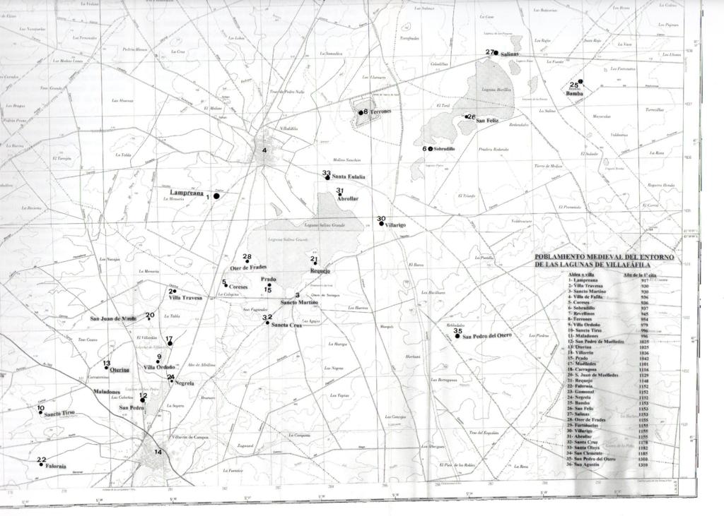
INDEX OF POPULATED NUCLEI (with reference to the year of its first citation).
Sancta Columba, Manganeses and Iahafes, which would possibly be included in Lampreana, are cited as limits of Iuncello in 1042.
The number given to the population is with a number marked on the map
VILLA TRAVESSA 2
It is documented for the first time in 930 and its last known mention is in 1060. Its name may be due, like many others from Tierra de Campos, to the anthroponym Travessa, [10] or to having a specific location or its term being "through ", or else has the meaning of traverse : "stop of boards or stones and earth to divert or contain the irrigation water" (Dictionary of the Royal Academy).
Between 930 and 937 the monastery of Sahagún acquired two and a half vineyards there. One road connected it with Sancto Martino and another with Lacuna Maiore.
In 945 Ramiro II donated this villa to the monastery of Sahagún and it is said that "sita est in Lampreana territory" . Mínguez affirms that this donation document is a forgery from the 11th century, and considers that this villa could have been donated to the monastery. at some point (Mínguez 1976: Doc. 99).
It is in 1049 when Ferdinand I donates Villa Travessa to the aforementioned monastery with express mention of its terms: "Et adhuc adicimus ad seruiendum ibi Uilla Trauessa, in loco Salina , in Lampreana et prado et serna per suis terminis: de termino de Recesco ; de Coressis et de illas Fontes et figen in posteros in termino de Domnos Sanctos" . From what it can be deduced that it was near the Salina, bordered on the village of Coreses and was close to the term that the friars of Sahagún already possessed (Domnos Sanctos refers to San Facundo and San Primitivo, invocation of the Leonese monastery).
Eleven years later, he returned to the royal family through a swap with the same monarch in exchange for Uillela, close to the monastery (Herrero, 1988: Doc. 534 and 612).
In addition to the above, there is another document from 962 that probably refers to this village with a nomenclature variation. It is about the delimitation of a property that Fortunio García donates to Sahagún "terra in Lampreana territory, on the eastern part, terminus of illas salinas and on the northern part, terminum de frates de Sancto Facundo, and on the western part, termini de homines de Villa Abtracies... " (Mínguez, 1976: doc. 196), which could well be a variant or incorrect transcription of Villa ab Travies.
From these data we can assume that Villa Travessa was located near the Salina Grande, San Martín and Coreses, possibly to the west of the salt flats. In my opinion, it would be located near La Raya between Villarrín and Villafáfila, to the west of the road that connects these towns and could correspond to the minor place name "La Tabla" (different from the old railway station), where medieval ceramic remains are found. [11] .
SANCTO MARTIN 3
It appears documented in the year 930 and 934 and in the apocryphal document of 945 (Mínguez, 1976: Doc. 36 and 99). It was located in Lampreana, near Villa Travessa, with which it was joined by a carrale and next to the "vestro de frates" terminus of the Sahagún monks, which we know from other documents was near the Salina Grande. This village could correspond to Otero de Sariegos, whose church is under the patronage of San Martín (Martínez Sopena, 1985: 62.), in the same way the only church located within the medieval fence of Villafáfila had this patronage. We could also place it on one of the plots, bordering the San Fagunde meadow, where medieval remains appear.
The church already belonged to the monastery of Sahagún in 934: " eclesia vestra de Sancto Martino in Lampreana ", which perhaps had been built at its expense in previous years or we could venture as a hypothesis that the origin of the hagiotopònimo must have been a monastic establishment or a old church, perhaps to which the Mozarabic or better late-Visigothic capital would belong, which serves as a baptismal font in the current church of Otero de Sariegos.
VILLA OF FAFILA 4
It is cited for the first time in 936, near the Salina Grande, and is documented in 954 as a village: "in Lampreana, in Villa fafila , palaces we obtain cun their hereditates" (Rodríguez Fernández, 1982: Doc. 20).
Remains from various periods have been found in the current urban area. The oldest documented settlement is from the first Iron Age, on the site of the old church of San Martín.
It is probable that the location of the early medieval village was closer to La Salina than the contemporary town: Iª Pautata ad Lacuna Maiore ad terminum de Abiza et de Pinniolo et de Villa de Fafila ..." (Mínguez, 1976: doc. 36) We have already mentioned the later correspondence with the town of Lampreana.
The etymology seems to correspond, as in many places in Tierra de Campos, to a common anthroponym from the 10th century, which would be the owner of a villa that gradually became a village. Various characters named Fafilaappear in contemporary documents. The first documented, Fáfila Odoariz, acts at the end of the 9th century, during the reign of Alfonso III, and is possibly the king's nephew (Granja, 1997); At the beginning of the 11th century, he acts in the court of Ordoño II Fáfila Baroncelliz, a character related to Bishop Sisnando of Santiago whom we find confirming a donation to the cathedral of Santiago in 911 ( Lucas, 1995 ), or in the confirmation of a document of Sahagun in 921 (Mínguez, 1976); Count Fáfila Olaliz and another Fafila confirm several documents from the cathedral of León, from 927 to 991 (Sáez, 1987; Ruiz Asensio, 1987); and others with the same name appear in the 10th century, confirming documents from the monastery of Sobrado (Loscertales, 1976 I: doc. 24, 56, 131.), and from other Leonese monasteries (Granja 1997).
Traditionally, without documentary basis, a Visigothic origin has been proposed for Villafáfila. Thus, Cesáreo Fernández Duro, in his Bibliography-Biography Collection of news regarding the province of Zamora , cites the founding of Villafáfila in the year 435, according to Gregorio de Argaiz in "Ecclesiastical population of Spain and news of its first honors. Found in the writings of S. Gregorio bishop of Granada and in the Chroninon of Humberto, monk of S.Benito.1667-1669.Tome III page 332 ”.
It has less foundation to relate it to King Fáfila or Favila, son of don Pelayo, who lived and died in Asturias in the middle of the 8th century. However, the original origin of a town with this name could well have been related to a rustic possession of the Doge Favila, father of Pelayo according to the Oviedo version of the chronicle of Alfonso III, whose scope of action seems to have been carried out at the end of the century. VII in the province of Astorga. (Frez Island, A. 1995).
In recent years, an attempt has been made to give a new etymological meaning by relating the name of Villafáfila to the "favilla salis" as the Romans called the finest salt, "which would in all likelihood end up lending its name to these humid places" (Delibes, 1993: 36).
CORESES 5
The first news is from 936 when the monastery of Sahagún buys a salt pan there: " pausata in Caureres iuxta carrale que discurrit a Zamora" . It is noteworthy the correspondence between this pause that the Sahagún monastery acquires in 936 with one of the lands owned by the Pious Memory of San Juan de Villafáfila, a pious foundation of 1523, which was made on the old properties of Sahagún and the Monastery. de Vega: "a land on the road to Zamora, to the right, boundaries, to the west Cureses lagoon , midday prairies of the council, north of San Fagunde, council." (AP Villafafila.)
In 1049, in the delimitation of Villa Travessa and a meadow that Sahagún receives from Fernando I, "de alia part of Coressis " is cited. (Blacksmith, 1988: doc. 534)
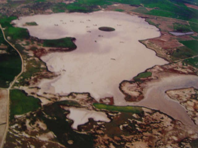
Although this minor toponym is not currently used, in the 18th century it was still called Laguna de Cureses, both in the Survey of the church of San Juan from 1763 (Villafáfila Parish Archive), and in the file on the rehabilitation of the salt flats. from Villafáfila in 1776 (AGS Direc. Gen. de Rentas 1ª Remesa nº2355) to a lagoon located to the southwest of the Salina Grande, known as Laguna Salada or Los Secadales or Salina Pequeña, on whose shores ceramics from the centuries are found. XI-XIII.
The place name refers to a name of Mozarabs from Coria, who would participate in the repopulation of Leonese lands in the 9th and 10th centuries.
OVERHEAD 6
The oldest reference we have to this place today uninhabited is from 937, regarding the confirmation of a document from the Abellar monastery of a donation made by Revel. Among the witnesses is "Teoderigo de Lampreana et de Sobratello " (Sáez, 1987: Doc. 118), nicknames that clearly indicate origin, and, due to the repetition, we can assume that Sobradillo was located in Lampreana.
It is mentioned again in 1310 as one of the towns, whose church was included in the Villafáfila cillero, and from which the Bishop of Astorga received tithes: “ et de la Eglesia de Sobradiello... dos moyos de sal ” (Cabero , 1989: 80). In a survey of the Palace estate of 1522 it is mentioned “ another land that is near Sobradillo that they say la Torre” (AHN Nobleza. Osuna 2152-16), as a toponymic reminiscence of the old church .
In the municipality of Villafáfila there is a payment with this name on both sides of the old Villalpando road, in a teso that dominates the Salina de Barillo and the Rual lagoon, where remains of medieval burials have appeared with large slabs of slate and sandstone. and ceramics of the type of pots with incised grids, marked bottoms and small containers, datable between the 11th and 13th centuries. Perhaps the toponymy is related to the name of the Barillos salt mine, which in the 16th century was called Vayllo, Sobradillo = Sobre Baryllo.
RAVELLINS 7
It is documented for the first time in the year 945 "in Lampreana territory" , near "karralo qui discurrit de Castro de Gundisalbo ad Lampriana" but not next to this road, since another "via qui discurrit de Revellinos ad Lampriana" is cited , when the Leonese monastery of San Pedro de Eslonza acquires an estate We know that the church of San Mamed was located near this road, in addition to mentioning a hermitage of sancti H. and some villares, which could be located in the payment of Los Villares in the current term of San Agustín (Vignau, 1885: doc. CCX and CCXI). The monastery of Eslonza continued during the 12th century acquiring properties in the place, confirmed in 1186, among which is its church of San Bartolomé (Granja, 1996: 62), possibly the current parish of Santo Tomás. Still in the 18th century, it conserved several lands and some forestry eras on the outskirts of Revellinos between the town and the Raya de Salinas.
It remained integrated in the jurisdiction of Villafáfila throughout the Middle and Modern Ages, following the same historical vicissitudes, until in the 19th century it became an independent municipality.
The name of Revellinos seems to derive from Revelle (Revel) > Revellines = children of Revelle (Martínez Sopena, 1985). Several times in the 10th century we find Revelle making donations to the Abellar monastery or confirming documents (Sáez. 1987). Its origin seems to be Mozarabic.
LUMPS 8
This place or village mentioned for the first time in 954 : "...et in Terrones pousadas VII em " (Sáez, 1990: doc. 274), was near some lake, since seven pauses are documented in its area. In 1116 it is cited again, included with other towns in Lampreana : "...et in Terrones racionem, et cuantum pertinet ad Sancta Maria in totam terra Lampredana” (Fernández Catón, 1991. Doc.1315). We know that it was near Villafáfila, since in 1155 it is cited as one of its border towns: "...de hereditate de Uilla Fafila.....habet enim iacenciam supra nominata uilla inter Oter de Frates et Furtunola et Terrones ".In 1147, the council of Terrones and its priest donated the church of Stª María de Villafáfila to the monastery of San Pedro de Eslonza: "ego Ciprianus presbiter una cum concilio de Terrones dabimus isto monesterio de Uillafafila perrominata Sancta Maria". (Vignau, 1885: doc. XIV and LXXVIII)
It is possible that the inhabitants of this village became part of the population of the town (becoming the council of Terrones in the council of Sancta Maria ), grouping together in a collation together with "alios homines bono de illo monesterio" around the church of Santa María del Moral, as occurred in other towns in Tierra de Campos, such as Villafrechós ( Martínez Sopena, 1985 : 182 ), since Terrones does not appear again in the documentation, nor is a current toponym preserved that informs us of its location But in several surveys of the sixteenth-century salt inns, such as the one carried out in 1522 by the commander, they describe " another inn of palaçio e ralladero questa al llama de Terrones " or“From there they went to another posada and ralladero that they say they call Terrones later on ” (AHN OSUNA 4201); or the survey of the monastery of Moreruela made in 1528 where it is said: "...an inn and ranch to the Llamares and the road to Villalpando that adjoins the town with land from Alonso Gonzalez and from the edge of the said land the llama de Terrones will face an inn that they said belonged to the monastery of Santa Mª del Valle...” (AHPZa. Disentailment. Box 238). The inns or salt flats will be the same ones that have been documented since the 10th century.
From the context of surveying, it can be safely deduced that it was located in the Prado de los Llamares , within the grounds of the “El Palomar” Interpretation Center, where human bone remains appeared, along with ceramics and construction materials in 1989. That same year, carried out an excavation that reveals ceramic materials from the 11th-13th centuries , together with superimposed structures with silos and abundant ashes (Sanz / Viñé, 1991).
Its etymological meaning can refer to the characteristics of the land or to a name of unknown origin.
VILLA ORDOÑO 9
On October 28, 979, the Mozarabs Marván, Abzuloma, Zuarez, Addelón and Allup delivered to the monastery of Santa Marta de Tera a court known by the name of Ordoño, which is in the lands of Lampreana, with all its trousseau and belongings. (Tumbo Negro de Astorga nº 89. Quintana Prieto, 1991: 15).
This first citation as court indicates the origin of what would later be known as Villa Dordonio in 1025: " ... damus uobis illas nostra uillas in Lampreana uilla Dordonio et fere in Sancto Petro cum suas Pautas..." (Ruiz Asensio, 1987: 422), when it is donated to the monastery of Santiago de Moreruela by Abiube and his cousins, whose shared possession would come to them by inheritance from their common grandfather. In 1158 it was donated to the aforementioned monastery by King Ferdinand II: "...illa villa mea que vocatur Villa Ordoni et est villa illa in Lampreana" (Alfonso Antón, 1986: doc. 10).
We know that it was near San Pedro, on land near a lagoon, since it had pauses.
The Cistercians of Moreruela established a farm, which was the system of exploitation of the properties of the white monks, confirmed by Pope Alexander III in 1163: "grangiam de Villa Ordonii et Auterol..." (Alfonso Antón, 1986. doc. 13) In 1183 his council is cited together with that of Muélledes: "Concilio de Moledes et de uilla Ordoniu cf" (Loscertales, 1976 II: Doc. 266), so we assume their proximity and a possible common future.
Etymologically, the name corresponds to the common anthroponym of the time: Ordoño.
Its location would almost certainly be near the lagoon located to the north of the town of Villarrín, called Villardón, which seems to be the etymological evolution of Villa (O)rdon(io), around which, especially on its shore north medieval pottery is located.
SAINT TIRSO 10
We know of its existence from a document from 996 included in the Tumbo de Sobrado (Loscertales, 1976 II: Doc.278 ) . It is about the donation of the town of Maladones, in Lampreana, to the monastery of Santo Tirso : "uobis Michaeli abbati, una cum fratibus tuis uel congregatione de Sancto Tirso et de Sancta Cruce et de Sancto Michaele et de Sancto Saluatore...usque in terminum of Sancto Tirso " . It is cited again in 1025 "...et uilla Auteriolo ad integro qumodo diuidet cum Sancto Tirso et per Lampreana..." (Ruiz Asensio, 1987: Doc. 824).
In 1152 King Alfonso VII donated the church of Sancto Tirso to the monastery of Santa Mª de Saar (La Coruña) "...illa ecclesia de sancto Tisso et de illa hermida de Sancti Petri, et iacent in terra de Lanpriana inter terminos de uilla Fafia et Tourum." (It must refer to those of Castro Torafe.) In other versions of the document , give more precise limits between Villarrín, Muélledes and Moreruela. In 1166 it was placed in the territory of Zamora and passed to the Cistercian monastery of Sobrado de los Monjes, who established a farm there, at the head of which there was a teacher and several monks, perhaps dedicated to the exploitation of salt, since in the donation from 1152 some salt pans that had previously been reputed throughout Lampreana are included: “ et cum omnibus suis salinis quas unquam habuit in tota ualle Lampredane ”. Thus, in 1179 appears: "In Sancto Tirso: Petrus Faber magistro cf, Rebote staleiro" suggestive of a saleiro or dedicated to salt; in 1185 in a privilege of Pope Lucius III the monastery of Sobrado is located in Tierra de Campos " ecclesia Sancti Tyrsi in Campis”and in 1203 several friars shared the farm: "iuxta alterum agrum fratum Sancti Tirsi ... frater Petrus Cidade magister grangie Sancti Tirsi, frater Rodericus ts., frater Martinus Cidade ts.,..." ; and the master of the farm is still cited in 1222 "Petro Fortunii magister Sancto Tirso” (Loscertales, 1976 II: doc. 42, 43, 44, 48, 198, 264, 265 and 277).
After its depopulation, its church became a simple beneficiary of the diocese of Astorga. : "...and on that day I present the loan title of Santo Esteban de Muelledes and Santo Tirso and Santa Maria de Falornia hermitages that are in the Villarrín district and are from Astorga and are owned by a racionero from Astorga..." Year of 1541. (ADA Codices 3-3,15 bis).
Its location is well known to the west of the term of Villarrín, in the toponym of the same name, on the Valdelafontana stream, where slate slabs , tegulae and Roman ceramics and medieval ceramic remains outcrop, indications of its occupation at both times.
The origin of the hagiotopónimo could be due to the old monastery with this dedication mentioned above, which could well have been located there since ancient times.
maladons
Cited for the first time in 996 as a town located in Lampreana, near Santo Tirso, with which it borders, in addition to citing as other limits "lacuna de Uallelo, Ualladade and auterum de Ambroce", without us being able to know if it is about other villages, or simple payments.
In 1152 it was documented again as one of the limits of Santo Tirso: "...et per omnes suos terminos antiquos colligente Maladones ...", between Villarrín and Falornia ."...et diuide cum uilla Rain, et inde ad Maladones et inde quomodo diuidit cum Falorne...” (Loscertales, 1976 II: doc. 48 and 264).
Its location, although unknown today, from what can be deduced from the context of its citations, had to be to the southwest of the terminus of Villarrín, and it cannot be ruled out that it is Moledes due to the phonetic similarity.
The meaning seems to correspond to a demonym, without being able to define its origin, although it may be related to mala or salina in the Arabic language (Asin 1944).
The citation of a Dominican Maladelo in Maladones in the year 1000 (Loscertales, 1986 II: doc. 46) may indicate his dedication to salt production.
In the 10th century, other minor toponyms in Lampreana also appear, although it cannot be determined whether they correspond to villages or to simple settlements or geographical accidents. They are the following:
Field: it seems to refer to a payment of Lampreana, where the monastery of Sahagún acquires several pauses between 933 and 937. It must not have been very far from Lacuna Maiore , because between the limits of a pause of that one it is cited "de alia parta de ripa de Campo .” It was also located next to the "termo de frates" , which we assume is located to the southwest of the Salina Grande.
Lacuna Maiore: there is no doubt that it was the current Salina Grande. It appears multiple times as the location of pauses , and helps us locate other toponyms.
Arcello: it appears mentioned in 946 as a place near Revellinos, with lagoons and salt flats “in lacunas de Arcello uindo uobis meas Pautas” (Vignau 1885: Doc. CCXI), a road connected both places, so its situation would be at the southeast of Revellinos near the Salina de Barillos, called Bayllo in the 16th century, which can be related to Arcillo or Arillo derived from Arcello . It does not appear documented as such again, although I suspect that it could be the village that was called Salinas in the 12th century.
Matronille: it is cited in 964 as the name of a salt pan in Lacuna Maiore next to the "career that runs from Breto ad Aratoi" . It is documented again in 1050 "pausata in Kalvello Matronil" (Ruiz Asensio, 1989: Doc.1074). In the 12th century it appears several times as a Matronil pause or saline, leading to a lawsuit over its possession. Currently there is a payment in the term of Villafáfila, to the northeast of the Salina Grande, known as Madorniz or Madornil, very close to the uninhabited Villarigo, in whose terms it was included in the 16th century, in which some medieval ceramics are found. The etymology of Matonille seems to be of Mozarabic origin (Cabero 1989).
In the documentation of the eleventh century we are given news for the first time of another series of villages or towns located in the territory of Lampreana.
SAINT PETER 12
Mentioned in 1025 and in 1158 together with Villaordoño in separate donations to the monastery of Moreruela. In 1152 it is cited with the church : "...et de ermida SanctiPetri, et iacent in terra de Lanpriana inter terms de uila Fafia et Tourum.."et ecclesiam Sancti Petri cum omni sua hereditate et salinis... iacet inter illas duas vias que sparten se in exitu de uilla Moledes, unam que tendit ad Sanctum Tissum et alia que ducit ad Sanctum Petrum, et ad Sanctum Petrum ducit ad Sanctum Tissum.." (Loscertales, 1976 II Doc 264). In the distribution of the royal breasts of the year 1462 it is distributed “to the council of Sant Pedro anmos the neighborhoods DCCCCXC mrs.” (EMR Leg...16-155), from which it is deduced that it was still populated on that date and the mention of the two neighborhoods that make up the council, possibly San Pedro and Oterino, which belonged to the Castrotorafe encomienda , and at the end of the 15th century, its terms were leased for sheep grazing and sowing bread to the residents of Villarrín or Villafáfila: " the terms of Oterino and San Pedro de Muélledes, which are from the horden of the encomienda of the said town of Castrotorafe with its lands and meadows and the tithes to said Mr. Don Enrique pertenesçientes in the said terms ". The rent in 1500 amounted to 100 loads of averaged bread, 50 rams and 50 hens (ARCh.V. Quevedo f. 1057-7). Its church was visited by visitors from the Order of Santiago and works were carried out on it in the 16th century. The tithes of him belonged to the commander in 2/9, and the rest to the maestrescuela of the cathedral of Zamora and to the convent of San Marcos de León. Its distribution gave rise to many lawsuits and concords such as that of 1549. There were also disagreements between the dioceses of Zamora and Astorga about the belonging of this town, and even in the aforementioned concord of 1549 it is said "that it belongs to the diocese of Zamora or of Astorga ” (AHN OO.MM. Book 1362). In the 17th century, the church still stood as a hermitage, with a hermit in charge of its maintenance.
In the 18th century, in the Cadastre of the Marquis of Ensenada, it appears as an uninhabited round term of San Pedro de Muélledes with 620 loads of land, belonging to the jurisdiction of Castrotorafe (AHPZa. Ensenada 1305).
It is located NW of Villarrín, less than a kilometer from the town center in a settlement where remains of pre-Roman ceramics appear, along with others from Roman and medieval times.
VILLA AUTERIOLUS 13
Also cited in the aforementioned documents of 1025 “... illas nostras uillas in Lampreana... uilla Aucteirolo ad integro ...” and 1158 " Auterol " together with San Pedro and Villaordoño; without ruling out that it could be the “ Ambrose auterium ” mentioned in the year 1000 (Loscertales, 1976 II: Doc. 278). In 1163 (Alfonso Antón, 1986: Doc. 13) he appears as one of the Moreruela farms and in 1183 he still had "magister grangiam" (Loscertales, 1976: Doc. 266). It belonged to the encomienda of Castrotorafe and its terms were leased jointly with those of San Pedro in 1500 "Know how many see this lease letter as I do Alº de Carvajal, mayordomo of Mr. Enrique Enríquez de Guzmán, commander of Castrotorafe, my lord, I lease and give for rent..., the terms of Oterino and San Pedro de Muélledes, which They are from the order of the encomienda of the said town of Castrotorafe with its lands and meadows and the tithes to the said Mr. Don Enrique pertenesçientes in the said”. Over the course of the 16th century, its boundaries were confused with those of San Pedro and in 1580 it is cited in a survey at the boundary of San Pedro de Muélledes "road that goes to Oterino" (AHPZ Notariales 4943) and the payment of Carraterino still persists in Villarrin. It is located in Villarrín, northwest of San Pedro.
VILLA REGINE 14
It is mentioned for the first time in 1038 and multiple times throughout the 11th century in relation to properties of pauses and salt pans located in its terms: "de illis pausetis ubi sal operantur" although its existence must date back to the 10th century, since these properties They belonged to the Leonese nobleman Pelayo Rodríguez who lived in those years (Ruiz Asensio,1989: Doc 970 and 1201). It is located in Lampreana and is indistinctly cited as Villa Regine or Villa Regini ,that over time becomes Villa Rain (Loscertales, 1976 II: doc. 264) or Villa Rein, and, sometimes due to cultured distortion, is written Villa Ferrin, when in 1237 (Trancón 1990: 24) or in 1257 (González , 1980) the villa is sold to the abbess of the Riojan monastery of Cañas. At the end of the 15th century it belonged to the Marquis of Astorga, Don Fadrique Osorio through his wife, Doña Mencía de Guzmán, passing to his daughter Isabel, wife of Don Diego de Carbajal, Lords of Jodar. With the depopulation in the Late Middle Ages of the villages that surrounded it, it was surrounded by a series of pastures and depopulated areas, some belonging to the same manor such as Muélledes or Falornia, and others such as San Pedro, Oterino, San Sadornín or Gamonal, linked to the encomienda of Castrotorafe, which ended up being integrated into its terms.
It always maintained good relations with the monastery of Moreruela, from whom the residents of Villarrín had leased the salt mines, and whose terms the friars' shepherds came to leave their cattle.
The etymology of Villarrín is of clear anthroponymic meaning in accordance with the majority of the towns of Tierra de Campos: Villa de Regine or, perhaps, Villa de la Reina, since near the village the Teso payment is located at the end of the 15th century. de la Reina (AHPZa. Disentailment box 242).
MEADOW 15
The first news we have of this place is about its donation to the monastery of San Salvador de Villacet by Oveco Muñoz in 1042: "et in Lampreana villa quem dicunt Prato ab integro" (Herrero, 1988: Doc.473) . From subsequent documentation we know that it had salt pans and was still populated in 1165: "...et in Prato uno corral cum suas houses et cum suas salinas in IIIIor parts..." (Serrano, 1927: doc 59), and that it was one of the towns bordering Otero de Sariegos in 1178: "...in Otero de Serigo....Iacet enim sapra nominata uilla en alfoz de uilla fafila. Formerly a part iacet Sancta Crux, ex alia part Prado et ex alia part Requexo."(ADLe.Gradefes Doc. 131), so I guess it could be found south of the Salina Grande, in one of the plots where pottery from the 12th century appears.
JUNCIEL
Cited in 1042 as a royal villa donated by King Ferdinand I to Keia Abze within the territory of Lampreana: "...et est ipsa villa in Lampriana territory, villa que nuncupant Iuncello ab integro, per suis terminis antiquis et Zabales simul cum Rubiolos ab integro et sont suos terminos per Sancta Columba et de alia pars per Rego de Lampriana sicut iurificavimus usque hodie, et ex alia pars per Maganeses et per Iahafes ..."(Alfonso Antón.1986: Doc. 1). The current term of Manganeses de la Lampreana is located. It is to be assumed that the villages that serve as a border to Junciel could integrate the territory of Lampreana, as is quite evident in the case of Rego de Lampriana , which is different from Riego del Camino, since in a contemporary document it is mentioned in the territory of Castrotorafe : "...Item in Rego Severi, who is in Ad Torabe territory prope monasterium Morairola medietate " (Ruiz Asensio.1989: Doc.970).
The lack of information in the ancient sources that I have handled does not allow me to venture the delimitation of the territory of Lampreana to the south.
In this century, other minor toponyms are cited within Lampreana, such as "illa Veiga" which possibly corresponds to "La Vega" by Villafáfila, and "Xaarich" cited in 1059 (Martínez Sopena, 1985: 406) without a precise location, therefore, although on the outskirts of Villafáfila instead of Las Pilas "El Cheril" is located around an old square pozarcón, there is also another similar toponym in Manganese, and, according to Francisco Rodríguez Pascual, it is a word used in the province of Zamora and Portugal with the meaning of a public fountain , generally covered.
The nuclei that are cited for the first time at the beginning of the 12th century are very likely to have already been populated previously. A) Yes:
MOLDS 17
It is mentioned for the first time in 1101, when Bishop Pelayo de Astorga and his canons bought an estate in Moledes, in Lampreana (Cabero, 1989: 33), and it has a long survival throughout the Middle Ages. It was found in the current term of Villarrín to the northwest, to whose jurisdiction it corresponded at least since the 16th century, occupying the terms of the Dehesa de Muélledes from La Recierta to those of Otero de Sariegos, likewise the hermitage of Santiesteban de Muélledes whose benefit corresponded to a racionero from Astorga. Existing independently San Pedro de Muélledes (the Sancto Petroquoted), and San Juan de Muélledes that we will see later. It had been uninhabited since the 15th century, and the lack of definition of its limits with Villafáfila gave rise to a lengthy lawsuit in the 16th century between the council of Villafáfila and Don Diego de Carbajal, also a lord of Villarrín, to whom the Muélledes meadow belonged.
In the limits of the Table it is mentioned "...adjacent to the unpopulated area of San Pedro de Muelledes, included in the jurisdiction of San Zebrian de Castrotorafe, with the untitled Molledes proper and jurisdiction of the owner of the town of Villarrín de Campos ( refers to the Marquis of Salvatierra) with another depopulated that is said to be the Valley of the Count of Venavente..." ARCH.V.) cited by (Granja, 1996). It was different from San Pedro de Muélledes whose jurisdiction belonged to Castrotorafe, while Muélledes or Moledes was included in the diocese of Astorga, with its hermitage of San Esteban de Molledes in the year 1541:"...and on that day I presented the loan title of Santo Esteban de Muelledes and Santo Tirso and Santa Maria de Falornia hermitages that are in the municipality of Villarrín and are from Astorga and are owned by a racionero from Astorga..." (ADA Codex 3-3,15 bis) However, the depopulated San Pedro de Muélledes did not pay tithes to Astorga in the 18th century.
We know that it was included in the territory of Lampreana from various mentions : "...in terra de Lampreana, Molldes ..." 1106 (Herrero, 1988), appearing cited under various Molledes variants in 1115: "et in Lampreana, in villa ue vocitant Molledes..." (Quintana Prieto, 1991: Doc. IX), Moledas in 1116, uilla Moledes in 1152, his council is cited in 1179, and in 1183 together with that of uilla Ordoniu (Loscertales, 1976 II: doc. 42, 265 and 266). It had salt mines in its terms whose sales are documented in 1183, and roads that communicated it with Santo Tirso and San Pedro. It was still populated in the 14th century, since in 1307 "Francisco Ioanes de Villafáfila lived in Muélledes"makes a donation to the bishop of Astorga (ADA Particular Index nº 565).
According to Cabero (1989) the toponymic meaning seems to correspond to settlers of muladí origin (Christians converted to Islam after the conquest), which has not had archaeological confirmation in the surveys carried out in the different plots where its location is supposed, although the They contain medieval materials, along with few Roman remains.
CARRAGOSA 18
Its existence has been known since 1116, regarding a list of the assets of the cathedral of León in various towns of Lampreana "...In Lampredana...in Carragosa " (Fernández Catón, 1990: Doc.1315), becomes to document in 1153 as one of the limits of Bamba : "et ex alia parte... Carragosa ...Isti sunt suis directuris de Bamba..." (Rodríguez González, 1966: Doc.25). payment called La Carragosa, on the Arriba road that went from Revellinos to Tapioles, so I suppose that this village would be located there, although I have not yet been able to locate ceramic remains of the time that could indicate the exact place of its location.
I do not know the meaning of this toponym that is also found in Castronuevo and next to Braganza.
OUTER
It is documented for the first time under this name in 1116, in the same list of the assets of the Cathedral of León mentioned above. It is doubtful that this is its first mention or that we can date it back to the 10th century in the case of considering the correspondence of the ancient village of Santo Martino with Otero de Sariegos.
In 1155 two different Otero are mentioned: Oter de Frades and Oter de Serigo, in the latter inns are documented (Vignau, 1885: doc. XIV and LXXXVII) and in 1178 we know that it was included in the alfoz of Villafáfila "...in Otero de Serigo...Iacet sapranominata uilla in alfoz de Villa Fafila..." (AHD de León. Gradefes nº131). In the fourteenth century, although the episcopal revenues of "the Church of Oter de Sirago" were included in the Cillero de Villafáfila, the town belonged to Arnao de Solier, and later passed to the Constables of Castile, but as a town with its own jurisdiction, not included in the alfoz de Villalpando, which belonged to the same gentlemen (Moreno Ollero, 1991: 403).
The toponymic meaning refers to the geographical accident on which it is based and the nickname of Sariegos seems to indicate a name, perhaps related to the extraction of salt, "saliegos", although in the documentation of the seventeenth and eighteenth centuries it is repeatedly mentioned as Otero de Seriego that seems to evoke Visigothic resonances, consistent with material remains from this period found near the current location of the town.
SAINT JOHN OF DOCKS 20
Cited for the first time in 1129, regarding the delimitation of the terms of Castrotorafe between Valmayor (which I suppose corresponds to the payment of the same name in Otero de Sariegos) and Bretó : "...et inde à Oter daguila et enter the race de Toro, et inde per Valmaior, et inde à Santo Ioane demoledes , et inde à Breton ... " (Cabezas Lefrer et al. 1991: 219). We can easily identify the toponyms: Oter del Aguila is located between Valderaduey and Lampreana "...ultram riulum de Aradoi contra Lampreana terminos scilicet...descended per Outer de Aguila (Tumbo de Castañeda nº 71), the village of Toro is known , Valmayor is a place name located in the south of Otero, and BretonIt corresponds without a doubt to Bretó; so we assume it is located south of the current term of Villafáfila, perhaps bordering on Muélledes, and possibly part of its terms, La Recierta, would be the source of litigation since the 16th century between Villarrín and Villafáfila. In 1484, a survey of the monastery of Montamarta mentions a land " between San Esteban de Muelledes and San Juan de Muelledes "; and in 1595 " a herreñal in the term of Muélledes between the two hermitages of San Juan and San Esteban, going along the path of San Esteban towards San Juan " (AHPZa. Desamortización.193). In 1506 it was cited as depopulated of San Juan de Muélledes (ADLe. San Marcos, drawer and file 4, nº 30.), and, still in 1751, there was a simple benefit of San Juan de los Yermos in Villafáfila.
REQUEST 21
This village appears documented in 1148 in Villafáfila: "...hereditetis...in Lampreane territory in uilla que uocitant Uilla Fafila....una posada in Requexo ..." I suppose it is located on land near a lagoon, since it is documents pauses in that year and in 1155: "...a court cum quator paused one in Vilarigo et alia in Abrollar et tercia in recheiso et IIII.ª in Oter de Serigo..." (Vignau, 1882: doc. LXXIX and LXXXVII). In 1522 the order of Santiago had two inns there to grate salt and others the monastery of Moreruela.
It was located near Otero de Sariegos, whose limits are cited in 1178 "...in Otero de Serigo... Iacet sapranominata uilla in alfoz de Villa Fafila...Ex una parte iacet Sancta Crux, ex alia parte Prado et ex alia part Requexo .” (AHD de León. Gradefes nº131), and more precisely between Villarigo and Otero, on the east bank of the Salina Grande, perhaps in Papahuevos, where there are medieval remains that can be traced back to the 11th century, such as ceramics with incised grids and marked bottom In a survey of the year 1670 it is measured "a land called requexo ... it borders... with a lagoon that makes the salt pan and meadow of the council " (APV, book 60) and in another demarcation of 1751 it is cited "a land in Requejohalf a quarter of a league from Otero to the Villalpando road" (AHPZa. Ensenada 957), all this serves to confirm its location.
FALORNIA 22
We have found it for the first time in 1152 with regard to the limits of the estate of Santo Tirso: "...ecclesia de Sancto Tirsso cum omni hereditate sua, quomodo diuidit per furnum de tegula intrante ad Moledes ubi uinguntur uie et inde ad Nigrelam et inde in promum colligendo eccesiam Sancti Petri et diuidit cum uilla Rain, etinde ad Maladones etinde quomodo diuidit cum Falorne et inde quomodo diuidit cum Manganeses, et inde per Gamual ..." (Loscertales, 1976 II: doc. 48) . In 1160 the monastery of Moreruela acquires estates in Falornia (Alfonso Antón, 1986).
Its location is known in the term of Villarrín, to the southwest of the town, where the hermitage of Santa Mª de Falornia was located, whose cemetery still existed in 1580, and whose manor belonged to the descendants of Doña Mencía de Guzmán, just like Villarrín.
GAMONAL 23
Also cited as the previous one as one of the limits of Santo Tirso, between Manganeses and Moreruela. It must have been included in the alfoz granted in 1129 by Alfonso VII to Castrotorafe, in whose terms it is included as depopulated in 1831 (Cabezas, 1997: doc.293). Already in 1499 it was a meadow belonging to the Commander who had leased the Irrigation Council for grazing his cattle (AHN OO.MM. Lib 1091). Currently there is a payment (National Topographic Map. Sheet 340) in Villarrín with this name, in the Manganese line. In the eighteenth century, the term of Gamonal had an area of 540 loads of land (Moreno, 1984: 216).
BLACK 24
Also cited in 1152 in the same document, near Muélledes, it reappears later with the same association: " in Moledes de Negerela " in 1179, and in 1183 the sale of one is documented: “ salina in Moledes et est in Negrela ". It would be located in one of the payments near the lagoons to the north of Villarrín, doubting its possible consideration as a village, or simple minor toponym.
BAMBOO 25
Place name of undoubted Visigothic resonance located between the terms of Revellinos and Tapioles, where late Roman and medieval ceramic remains appear (Martín Valls / Delibes de Castro 1977). In the medieval documentation it is mentioned in the territory of Lampreana in 1153, as a donation to the monastery of Castañeda by the infanta Sancha " hereditary quam habeo in Lampreana, scilicet de Bamba ....Habet enim iacentia inter Sanctum Felicem et Salinas et Tapias et ex alia part is Malelos et Ceresinos et Carragosa." . In addition, "...cum suo villare de Ferrarios..." is mentioned as a possible neighborhood or remnant of an old settlement. In 1155, the monks continued to acquire vineyards from different owners, which seem to have been concentrated, together with the orchards, around the church of Santo Tomé: "Sunt ipse uinee in Territory of Lampreana sub classroom Sancti Thome de Bamba " "...at the peral....al pumar...al vimneru...in illa Cortina de Bamba , tam vineas quam perales” (Rodríguez González, 1966: Doc.25, 30 and 33) , which belonged to the monastery in 1193, when Inocencio III confirms the possessions of Castañeda (Mansilla, 1955) Possibly the small lagoons that are located in the surroundings of the old town were used as salt mines.
HOLY HAPPY 26
Cited in 1153 as one of the limits of Bamba, I do not know its exact location, because of the context it seems to be located near Salinas, between the two. It is cited again in 1211 with salinas but as not included in Lampreana: "... salinas quas habebant in Lampreana, et in Sancto Felice , et in Moladas...", (González, 1944: doc. 274) although in 1310 the diocese de Astorga received income from his church, included in the Villafáfila cillero "... et de la Eglesia de San Feliz carries a moyo de sal..."(Cabero, 1987). In 1498, in a lawsuit between Don Enrique Enríquez and Don Pedro de Ledesma over the lordship of the terms of Salinas and San Feliz, the two were cited together, for what would correspond to two different villages with the same lordship, which, when one of them was depopulated before they, in this case San Feliz, ended up being confused (ARCh.V. Alonso Rodríguez D.10-9). In a description of various terms of Villafáfila in the first half of the 16th century, some of which we know with certainty correspond to former depopulated areas, “la Vega que dizen de San Feliz ” is mentioned (OO.MM Lawsuit 5514), possibly because its proximity to the old village, or because part of its terms ended up included in those of Villafáfila.
SALINS 27
Also cited in the year 1153, in the same document, this town remained inhabited until the 16th century, "in the place of Salinas, which has been deserted for seven years a little more or less," says a witness in 1537 (ARCh.VPC Moreno 2794 -1), outside the jurisdiction of Villafáfila but integrated into its archpriesthood. Among the assets that the Admiral of Castile, Don Alonso Enríquez, and his wife, Doña Juana de Mendoza, included in the mayorazgo that they founded in 1426 in favor of their second son, Don Enrique, first Count of Alba de Aliste, include "the salt pans que son çerca de Villafáfila ”, which seems to refer to this place. Subsequently, Count Don Enrique took them out of the mayorazgo in exchange for other assets, " with the power and license of Mr. King Don Enrique”, and sold them to Luis Vaca, a neighbor and alderman of Zamora. After his death, his heirs exchanged them with the then Commander of Villafáfila and Castrotorafe, Don Pedro de Ledesma, who had to defend his possessions in various lawsuits with Don Enrique Enríquez de Guzmán, son of the Count of Alba. In the lawsuit, several residents of Revellinos had testified in favor of the Enríquezes " because Don Alonso and Don Diego had promised them that they would be given the said place in Salinas so that they could work on it for free, so that they would only pay the tithes " (ARCh .V. Alonso Rodríguez D.10-9). In 1482 the council of the place of Salinas requested that of Villalpando to grant them the same ordinances of terms that they had established with that of Villafáfila (Moreno Ollero, 1991).
The benefit of its church was to present the widow of Pedro de Ledesma, alderman of Zamora in 1536. After its depopulation it remained as a meadow that was leased for cattle. The Dehesa de Salinas appears in the Ensenada Cadastre with an estimated area of 875 loads of land.
Its location is known to the south of Revellinos on the shore of the Salina de Barillos, where ceramic and construction remains can be seen and its terms reached from near the center of Revellinos to Trancalón, bordering on Tapioles and Cerecinos. Its name is clear referring to the activity that gave rise to its origin.
OTHER OF FRADES 28
It appears for the first time in 1155 as one of the limits of Villafáfila: “Habet enim iacencian supranominata uilla inter Oter de Frades et Fortunola et Terrones ” (Vignau., 1885: doc. XIV), we know that it is different from Otero de Sariegos because that same year appears cited with the nickname of Serigo. In 1183 it was inhabited, as a Domnus Pelagius capellanus by Oter de Frades confirms a document of distribution of Maguetes between the Moreruela and Sahagún monasteries. In 1201 we know that it belonged to the monastery of Sahagún, hence its name, and that it was in the process of being depopulated or already depopulated, because in the lease made by the abbot that year, he makes it a condition for the tenant to rebuild the church and build the houses:"you must, insuper, ecclesiam reedificare, domos facere..." (Fernández Flórez, 1991: Doc.1409 and 1544), probably due to the transfer of its population to Villafáfila during the process of organizing the town to settle in the collation of the Church of San Miguel that belonged to Sahagún.
There are two possibilities regarding its location: that it was located in the Torrefrades toponym of Revellinos, but there are no traces of settlement, or in Teso de los Plateros, next to the San Fagunde meadow in Villafáfila, where there are remains of a medieval necropolis, also in that area until the 16th century was the term of San Fagunde, integrated into those of Villafáfila, but with its own boundaries that even gave its name to the part of the Salina Grande located in its surroundings that received the name of Salina de San Fagunde. In this term, known as term de frates since the 10th century, it was where the monastery had its salt pans and possessions.
FORTUNE 29
Toponym cited in 1155 as one of the limits of Villafáfila: " habet enim iacenciam supra nominata uilla inter Oter de Frates et Furtunola et Terrones" (Vignau, 1885: doc. XIV), seems to refer already then to a village, since the other two they are, although in 1182 it is mentioned as a payment of the same , indicating that it would be included in its alfoz "...in Uilla Fafila in bago de Furtunola ..." (Vignau, 1882 p. 167).
It is located between the terms of Villafáfila and San Agustín where the toponym of Raya de Fortiñuelas persists . Thanks to the testimonies of several residents of these two towns in a lawsuit, which in 1530 arose between the council of Villafáfila and the prior of Nª Sra. de la Puente for the use of the pastures of this territory, we know that it was populated until the middle of the of the fifteenth century. Pedro Gallego, 80 years old, says that he remembers seventy years in this part (since 1460) and: "he saw the town of Fortunuela and he met two people who later went to live in Santa Elena, when the said term and place were depopulated. that there were houses and a texada church with a small bell ", another witness recalls that: "he saw certain walls and a church and a saint who was called the church of San Pelayo ", possibly the population in those years was seasonal, since another resident of Villafáfila says that " he saw in Fortiñuela three houses in which he knew two people who were there lived fleeing from the pestilence of Villafáfila, he saw and remembers seeing a fork in a teso that is above where the place of Fortiñuela used to be populated ", a symbol of independent jurisdiction, located in what is currently called Teso de la Horca de San Agustín. At the end of the 15th century, the priors of Nª. Sra. de la Puente made attempts to repopulate the place: " this witness of fifty years here that you remember (since 1480)He never saw Fortiñula populated, but he remembers that he wanted to populate it again and that he saw that in it they began to build houses and some of the inhabitants lived there, that this was at the time the Jews left, and that later this witness saw that was depopulated again, he doesn't know how or why ", but the population did not remain, and since then it has remained like a pasture. (ARCh.VPC Moreno 2794-1).
In the Cadastre of the Marqués de la Ensenada (AHPZa.) appears the Dehesa de Fortiñuela, belonging to the Priorato del Puente, located in the current term of Milles de la Polvorosa, daughter of the regular canons of San Agustín de la Abadía de Benebibere de Carrión of the Counts. It had about two hundred and twenty surface loads and extended from the Valley to the meadows of the Dehesa in the Raya de Revellinos. In 1700 "residents in the house and farm of Fortiñuelas " are cited (AH P.Za. Notariales 11749) and throughout the 18th century some families still lived in their farmhouse (AP San Agustín). During the disentailment process of the 19th century, various residents of San Agustín acquired ownership of these lands, divided into quiñones, and became part of their municipal area.
The uninhabited area is located a little less than a kilometer south of San Agustín, near the Fuente de la Dehesa, where ceramic remains can be found that can be traced back to the 11th century, such as pot fragments with incised grid decoration.
Its meaning seems to be related to the anthroponym Fortunio, common in the 10th century, homonym of Ordoño.
VILLARIGO 30
We know of the existence of this village, originally cited as payment for the location of a " pause ", since 1155: "...in Lampreane territory in uilla que uocitant Uillafafila...quatuor Paudas una in Vilarigo ..." (Vignau, 1885: 140) from which its proximity to the Salinas is deduced. In 1310 his church is cited as "...e de la Eglesia de Villarigo ..."(Cabero, 1989) belonging to the cellar of Villafáfila, dedicated to Our Lady. The terms of Villarigo continued to be a point of reference in the surveying of land or salt flats during the 16th century. The church remained standing until 1811 as a hermitage and brotherhood of Villarigo where the image of the patron saint of Villafáfila was venerated, and where the residents of Villafáfila, Revellinos and Otero went on a pilgrimage, perhaps as a reminder of the origin of some of their ancestors who in the Late Middle Ages emigrated to these towns.
It is located a little over a kilometer to the east of Villafáfila near the bridge, on the path from Benavente to Toro, and remains of stones, slabs and pottery made with a lathe with incised grid decoration of medieval chronology are still found today. .
ROLL 31
The only citation of this toponym is in the aforementioned document from 1155: "in uilla que uocitant Uillafafila una corte cum quatuor Paudas una in Vilarigo et alia in Abrollar et tercia in Recheixo et IIIIª in Oter de Serigo..." , from which it follows from the context that it is a village of Villafáfila, since the other three are, and that it would be located near the Salina Grande, between Villarigo and Requejo, perhaps in the medieval site of Cabañica II.
HOLY CRUX 32
The first and only reference is to the aforementioned Gradefes document of 1178, when it is mentioned as one of the towns that border Otero: "ex una parte iacet Sancta Crux . ex alia parte Prado et ex alia parte Requexo". Perhaps it can be located to the south of the current town of Otero in one of the several places where remains of ceramics from medieval chronologies appear, on both sides of the Villarrín road.
SANTA EULALIA 33
In 1182 the monastery of Eslonza receives "illas pousadas... ad sancte Eolaliam " (Vignau 1885: doc. CV) so it had to be located near the lagoons. We have no more medieval references, so there could be doubt that it was a simple payment. In the year 1499, a survey mentions “the land of Santa Olalla, boundaries... and the road that goes to Toro and goes out to the foyos and the cabins are fasia” (ARCh.V. Zarandona and Walls 1353-8 olv. ) . In the survey of the inns of the monastery of Moreruela in 1528 (AHPZa. Disentailment. Box 238) it is said: "they went to an inn where they say Santa Olaya.... with land they call Villar de Santa Olaya....on the hand drª façia Santa Olaya and from there it returns towards the town... and a trrª de Sant Martyn that is at the path of Santa Olaya" . And for another felling of the lands of the church of San Martín de 1705: "two cebadale lands to Fuente Aldea are divided by the road that goes to Villarigo..." (APVfª). With these references it can be assumed to be located in "El Villar" next to Fuente Aldea where remains of burials appear superimposed, in addition to medieval ceramics (Rodríguez / Larrén / García 1991) A trail linked Santa Olaya with Terrones in 1522.
SAINT CLEMENT 34
Although the first citation is from 1185, regarding an agreement between the bishop of Astorga and the abbot of San Claudio de León on the church of San Clemente de Fortiñuela, since before 1178 it had been illegally consecrated by a heretic (ADA Particulars Index No. 572). Although San Clemente bears the nickname of Fortiñuela, it is a different village than the previously mentioned one and distanced somewhat more than 1 km in a straight line, since at the beginning of the 16th century the term of San Clemente is cited, within those of Villafáfila, together with the of Fortiñuela, but separated and apart from them. In 1522, the Order of Santiago owned several herreñales in that place, one of them “ below the tower of San Clemente ” (AHN Nobleza. Osuna 2152-16).
In its terms, bordering to the east with the El Riego stream, inns and old threshing floors are documented at the beginning of the 16th century, undoubtedly remains of an old salt exploitation.
The depopulated area of San Clemente de Valorio is cited in 1708 as one of the districts that had bought the town of Villafáfila, unlike Fortiñuela, which until the confiscation belonged to the Priory of the Bridge and was later integrated into the district of San Agustín. From this town a path to San Clemente started in the 16th century, which reached Villafáfila, corresponding to the old path of San Agustín.
The specific location of this medieval depopulated is located in La Somadica, where in a survey of 1702 (AH P.Za. Notariales 11749) it still receives the name of La Torrica de San Clemente, with a clear population reference and where corresponding ceramic pieces appear a chronology from the end of the 11th century to the 15th century.
SAN PEDRO DEL OTERO 35
Although its church belonging to the Villafafila cillero "... Church... of San Pedro del Otero ..." is not documented until 1310 , from which the bishop received two moyos of salt as a tithe (Cabero 1987), the remains that appear in its surroundings date from the 11th century according to the ceramic finds, such as the remains of turned pots with incised grid decoration.Since the end of the 15th century, a town in Villafáfila has been named San Pedro del Yermo, which which indicates a reference to depopulation and in 1522 the memory of the tower of the old church in one of the commander's lands is mentioned: " that is said the land of the tower of San Pedro bordering Cañiço road ..." As sign of the old lordship persisted in 1498 the " palaçio iron ”, as Rollo. Since then it is easy to identify the "San Pedro del Yermo" payment in the Loma, including the Fuente de San Pedro, in the boundaries and surveys of the land. Its location is detected in one of the mounds or mounds to the north of the Cañizo road, where remains of tiles, slabs, ceramics and bones, separated from the Roman site, can be seen.
Its location somewhat away from the lagoons raises the question of the place where they would extract the salt that they were obliged to deliver to the Bishop of Astorga. Two possibilities are pointed out: either that their terms reached the Laguna del Triunfo, or that they had the collective property of some inn on the banks of the Salina, as documented for San Agustín.
SAINT AUGUSTINE 36
The same happens with this town, which is not cited until 1310, but its origin must be earlier. Its terms, jurisdiction of Villafáfila, were separated from those of the town by the terms of Fortiñuela, which reached the orchards of San Agustín. The path of Toro crossed its square, and in its terminus is the payment of Los Villares, where the monks of Eslonza acquired properties in 946. On its outskirts there was a hermitage of the Cross in the 18th century, which could correspond to the ermiario sancti H cited that year.
It remained integrated in the alfoz of Villafáfila throughout the Modern Age, sharing its historical events with the town and Revellinos, until it became an independent town hall in the 19th century.
Its meaning corresponds to a hagiotoponym like most of the late repopulation nuclei and could be related to the regular canons of San Agustín, owners of Fortiñuela.
The salt that they also delivered to the bishop of Astorga, as in the previous case, would have to be obtained from some small lagoon located in the lowest payments of its terms, although the Fortiñuela terms occupied the meadows that reach Revellinos, or from the inn documented in 1528 as " Santo Agostyn " near the Salina Grande.
Documentation from the 12th and 13th centuries cites various toponyms that seem to correspond to payments for farming or salt flats:
- Salina de Quintanella 1153: " et inde a la salina de Quintanella et in ipsa Quintanella habet sua madietate " (Rodríguez González, 1966: doc. 25). Due to the context of the terms to which it serves as a reference, it would be close to Salinas in the current Revellinos.
-1177 " in Uillafafila una Pauda ad Laroia " (Vignau, 1885: doc. XCVII), which can perhaps be located in the payment near the Prado de los Llamares called Ribas Roias , where salt streaks are documented in the 16th century.
-1182 ".....et Iª pousada in ostes iuxta carcauam" (Vignau, 1885: doc. CV). Ostes probably corresponds to the payment of Santioste in Otero de Sariegos, where slate slabs and some medieval ceramics have been found.
-1199 " to the Monago lagoon " (Vignau, 1885: doc. CXXII).
-1200 " salinas quam tu habes in loco permanato del Rodezno " (Cabero, 1987: doc. III).
-1283 " the estate of Pobladura , in Villafáfila, two salt mines - one of them from Santa Marina -..." (Martínez Sopena, 1985: doc. 1083).
-1310 "a salt pan of Santa Marina ....., a land where Puebla used to be ...” (Cabero, 1987: doc. VI). During the 16th century, orchards or herreñales were frequently mentioned in “ do they say la Puebla” , which from the references seems to be located to the west of the town, possibly between Las Pilas and Alameda.
Text: History of salt mines in the Villafáfila lagoons. P. 29 to 53. Zamora: Institute of Zamoran Studies "Florián de Ocampo", 2000. ISBN 84-86873-87-8. Photography: Elijah Rodriguez Rodriguez. JF Lorenzo, lease. Jose Luis Dominguez Martinez.
Transcription and montage: Jose Luis Dominguez Martinez.
All text, photographs, transcription and montage, their rights belong to their authors, any type of use is prohibited without authorization.
All text and photography has been authorized for storage, treatment, work, transcription and assembly to José Luis Domínguez Martínez, its dissemination on villafafila.net, and any other authorized means.
[1] In addition to the owners mentioned between 930 and 937, other Mozarabic resonances from the Revellinos environment of 945 and 946"... Elias cognomento Zulaimen, Mantelle, Ziti, Zaanton, Juliano aben Motaher..."(Vignau, 1885. doc CCX), or "...Marvan, Abzuloma, Zuarez, Adelon and Allup..."in 979, in Villa Ordoño (Quintana Prieto. 1991: 15).
[2] References to the territory: - "...et ipsa Villa de Travessa which is located in the territory of Lampreana..." .Year 945. - "...in Lampreana territory just a town that called Reuellines...". Year 945. -"...in Lampriana territory in locum predictum iusta villa que uocitant Revellinos..." .Year 946. -"...in Lamprean territory..." . Year 962. -"...et ipsa villa est in Lampriana territory, villa que nuncupant Iumcello..." .Year 1042. -"...in Lampreane territory in a village that uocitant Uilla Falila...". Years 1148, 1155 and 1177. -"...in Lamprehane territory in a town that Uilla Fafila dictated..." .Year 1153. -"...in the territory of Lampreana subclassroom Sancti Thome de Bamba..." .Year 1155. -"...nostram salinam...in Lampreana territory...". Year 1200.
Mention with other references: - "...in Val de Lampreana Villa Regine..." .Year 1077. -"...in terra de Lampredana, Molldes..." .Year 1106. -"...ecclesia de sancto Tisso et de illa ermida Sancti Petri, et iacent in terra de Lampriana... ". " ...cum omnibus suis salinis quas unquam habit in tota ualle Lampredane...". Year 1152.
[3] If it is not in the current urban center (on the outskirts of it there is a site that provides late Roman remains, TSHT, and at the other endthe Visigoth treasure), it could possibly be located in one of the settlements with medieval remains located to the south of Villafáfila such as "El Pradico" where there are medieval remains such as pottery with incised grids and marked bottoms, with a chronology from the 11th century, together with burnished gray ceramics that can be traced back to dates prior to the 8th century or "El Teso de los Plateros", a promontory next to the Salina Grande with medieval ceramic remains, burial slabs and human bone remains.
[4] FLOREZ Sacred History Year 1742 Volume XVI. Appendix No. 29.
[5] National Library. Mnss. 4357. Tumbo Negro de Astorga, fol.72 v. “Another donation to the StªIglª de Astorga and hers obº D.Fernando of all the thirds that he owned in the Iglªs in this Obdo. as contained in the sacred canons, such as that of Villarrín , that of Bretó. Castropepe, Castrogonzalo... Date 16 Kals. May Era MCLXXXXV”.
[6] During the twelfth, thirteenth and fourteenth centuries, both Pajares and Manganeses appear in the documents many times without a nickname; Villalba in 1216 documents “que est in termino de Castrotorafe”, and in the delimitation of 1224 it is reiterated“Villalba in alfoz de Castrotorafe que sita ist inter Villarrein et Muscas et Castrum Novum et Manganeses” (AHN OO.MM. Lib.1363 ) and in 1481 the nickname was already added:"in the place of Villalva de Lanpryana"(Vaca Lorenzo, 1991: 31). Starting from the Late Middle Ages, the Salado valley is sometimes called Lampreana, thus in 1311 it is cited"Cereyssinos, village of çamora, which is in Valde Lanpreana"(Alfonso Antón 1986: 529).
[7] Between 1181-1185 Pope Lucio III orders the bishop and archdeacon of Zamora not to disturb the bishop of Astorga in the possession of the churches of San Pedro de Muélledes and Villarrín, which have been unfairly appropriated. (National Library. Mss. 4357, fol. 244 r.). The same pontiff in 1181, through a brief, commissioned the bishops of Salamanca and Zamora to intervene in the pending controversy between those of León and Astorga over several churches, among others that of Tapioles (ADA Index. Apostolic p. 245 ).
[8] "Curtis" is a central courtyard around which there were several buildings and outbuildings, sometimes surrounded by a fence. It represented the base of a manor (Gª de Valdeavellano, 197). In modern times it receives the name of Cortina, an agrarian property, generally fenced, included or attached to the corrals of the houses and often dedicated to the cultivation of orchards or pasture. [9] I only mention the toponyms that I believe were included in the former territory of Lampreana. In some documents, nearby villages appear as the limits of others or as the origin of confirming ones. This is the case ofCeralsinor (Cerecinos de Campos),Villa de Auriolo(Valdescorriel),sancti Micaello(possibly San Miguel del Valle) in 946 (Vignau, 1885: doc. CCXI). Some towns that I believe are outside the scope of this study are cited as limits of Bamba, such as Tapias (Tapioles), Malelos, Froianes, among others in 1155. (Rodríguez González, 1976 doc. 25).
[10] Travesa appears confirming a document from the cathedral of León from 983 (Ruiz Asensio, 1989: Doc. 492)
[11] Although Fátima Carrera de la Red places it in Villalba de la Lampreana because there is a path from Villarrín to Aspariegos or Carratraviesa, there is also a Carratraviesa toponym in the Manganeses district (National Topographic Map page 340). In the minor toponymy of Villafáfila in the year 1449 it is mentioned"a herreñal to the Traviesa carrerina"(Zarandona and Wall. 1353-8 olv) and in Otero de Sariegos in 1751 it is mentioned"a land called Carretrabiesa half a quarter of legua"(AHPZa. Ensenada 957), which may correspond to the old road from Villa Travessa to Sancto Martino, or all of them refer to the fact that the aforementioned road followed a path crossing others.
|
|||||||||||||||||||||||||||||||||||||||||||||||||||||||||||||||||