ROMAN BRIDGE OF VILLARIGO OF VILLAFÁFILA

|
ROMAN BRIDGE OF VILLARIGO OF VILLAFÁFILA |
|
|
|
|
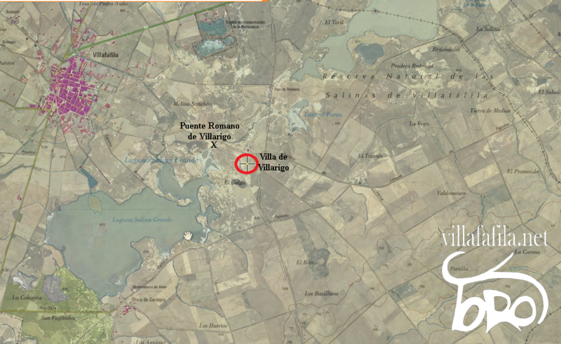
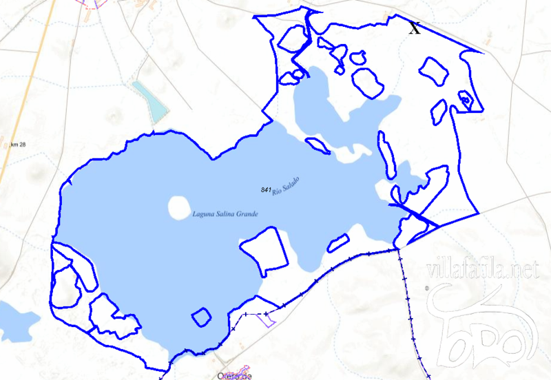
LOCATION Roman Bridge of Villarigo, this name that it receives for being in the vicinity of the old town of Villarigo.
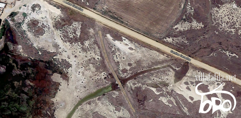
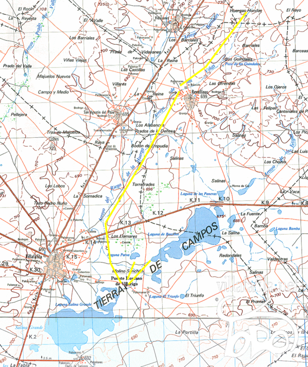
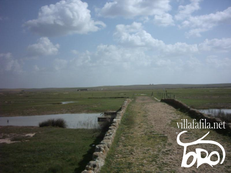
It is located east of Villafáfila, about approx. 1.60 km, approx. 400 m from Laguna Salina Grande, approx. 100 m from Laguna el Puente, and close to the Carrerina path, 62 m from where it can be seen perfectly. Longitude: 41°50'26.8"N. Latitude: 5°35'35.4"W. https://goo.gl/maps/7Bjnu4mWSgibShiQA
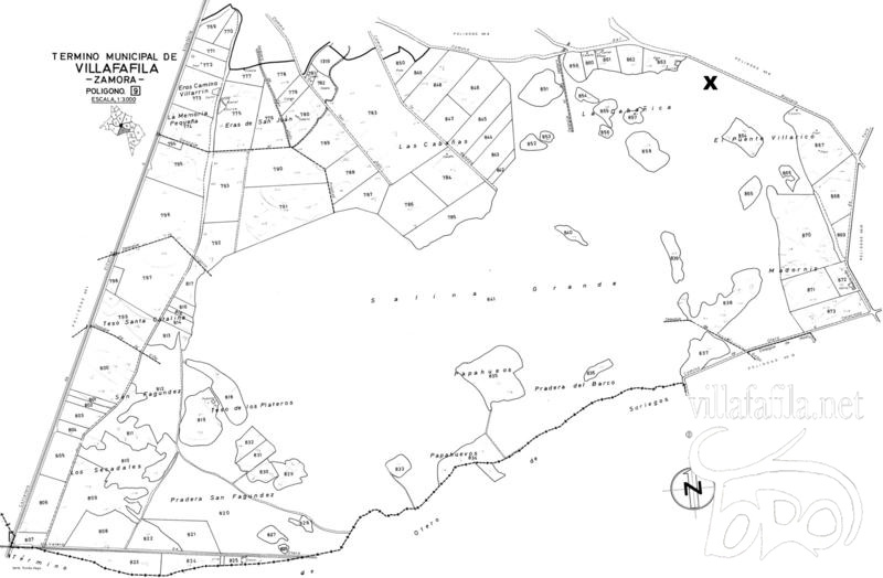
On the plot concentration map of Villafáfila, polygon 9, plot 841.
Cadastral reference: 49271A001008410000FO. Location: Polygon 1, Plot 841. BIG SALT FLAT. VILLAFAFILA (ZAMORA). Class: Rustic. Main use: Agricultural. Graphic area: 2,763,827 m 2 . Cultivation/Use: E-pastures.
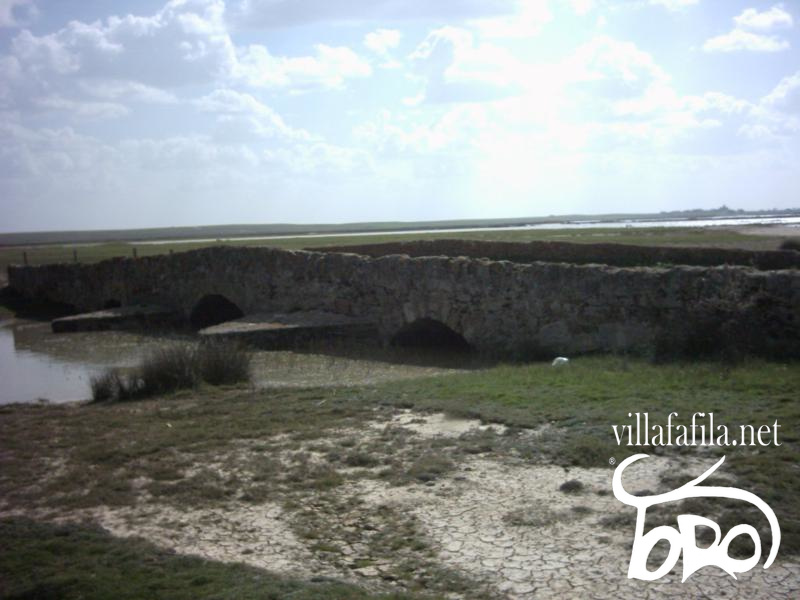
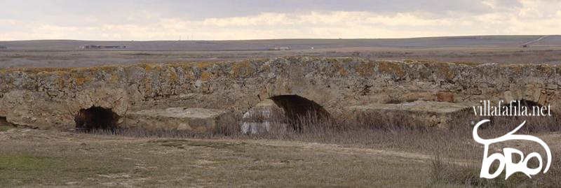
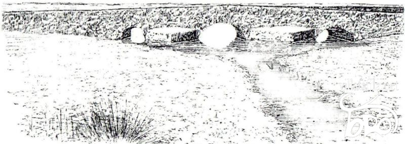
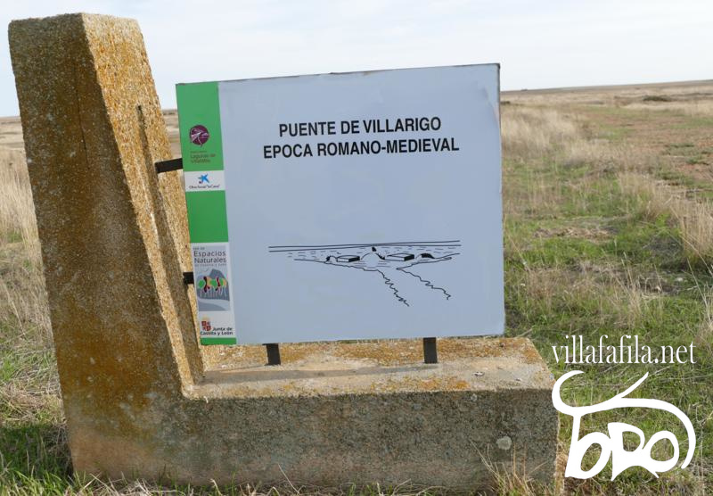
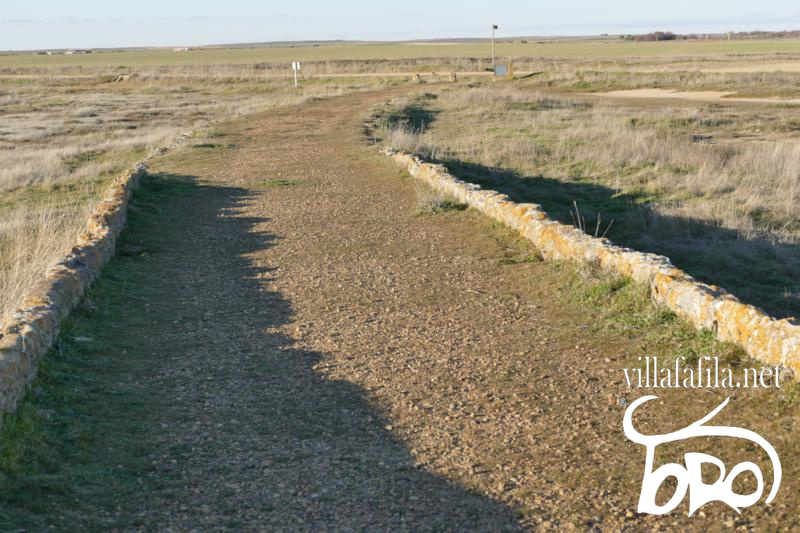
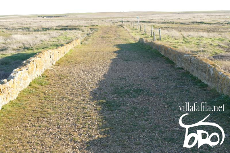
DESCRIPTION It belongs to the time of the High Roman Empire 27 BC to the year 305 AD The bridge currently has: Bridge length: 35 m approx. Path length: 120 m approx. Width of the bridge and the road: 4 m. Between the 30 cm high ashlars, along it.
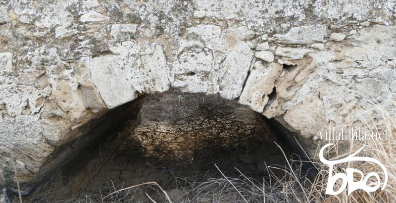
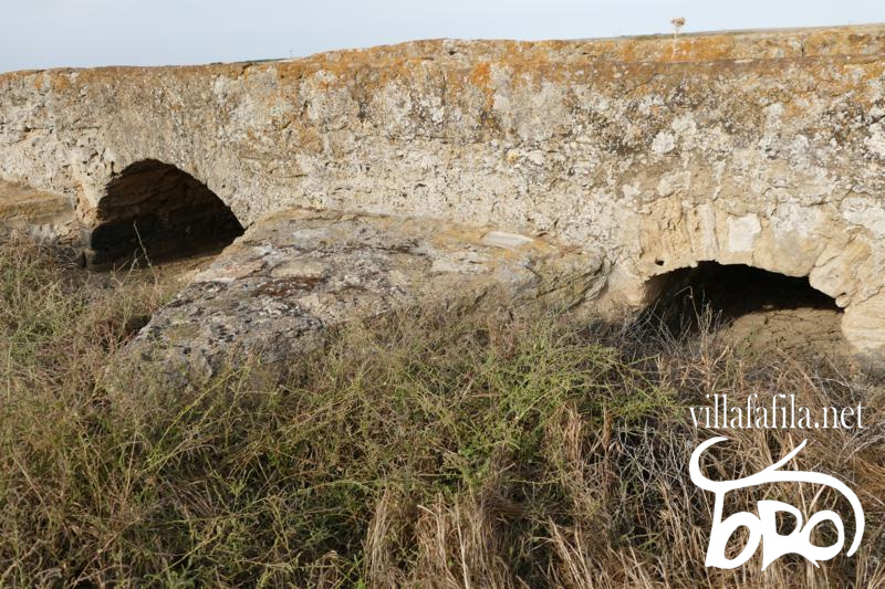
Although heavily rebuilt, it features: Three arches, unequal in size, semicircular, the central eye is double the lowered sides.
With strong ashlar voussoirs (each one of the wedge-shaped carved stones that make up an arch or vault).
Separated from each other by four breakwaters, two upstream and two downstream.
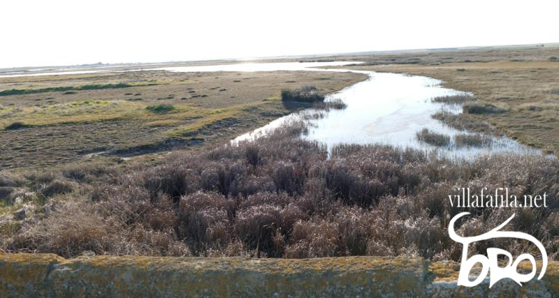
Even though the entire group that forms the Lagunas de Villafáfila is largely clogged by clayey drags from the surrounding tesos, the height of the bridge in its origin must have been more remarkable, since it is said in the local tradition of Villafáfila that "by a man on horseback passed his eyes”, perhaps this is more a greatness of the saying that is not true, but it was taller than the current one.
Through it passes the waters that come from the Riegos stream from San Agustín to Villafáfila, receives waters from the Los Llamares meadow and the one that drains from the Laguna de Barillos through the Salado stream, which all go to the Laguna Salina Grande. .
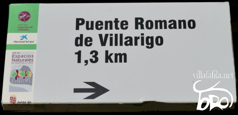
RESTORATION This bridge was restored by the JCyL through the Villafáfila Nature Reserve around 2008, if it consolidated its masonry. Signposts for the bridge were placed at the exit of the Camino de la Carrerina indicating the direction of the Puente Romano de Villarigo, and on the bridge itself.
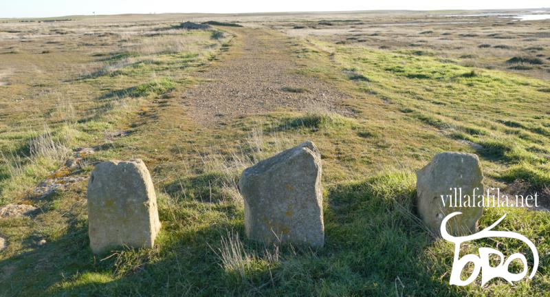
The side of the road of the bridge that faces the Camino de la Carrerina is delimited by three large stones to delimit it and no vehicle passes through it.
The stretch of road where the cobblestones of the original path were seen, was laid over gravel, covering the original cobblestone, and it has continued like this until today.
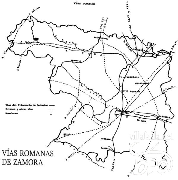
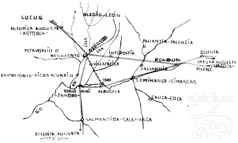
ROMAN ROADS THAT CONFLOWED THROUGH THE ROMAN BRIDGE OF VILLARIGO Two Roman roads [1] of the second order converged through it and seem to be heading: 1st. It joined the valleys of the Esla de Petavonium or Brigaecium (Benavente) passing in the direction of the Roman Bridge of Villarigo, saving the Villafáfila lagoons, it communicated the settlement of the late Roman town of the Fuente de San Pedro and with the Fuente de San Pedro itself until reaching to connect with the Duero in (Albocela-Toro) following the Vereda de Toro to Toro. This road was later a Vereda called Vereda de Benavente a Toro. Centuries later, in 1129, "et to enter the bull's race" is cited in the delimitation of the alfoz de Castrotorafe, granted by Emperor Alfonso VII of Castile. The influence that this secondary Roman road has had on the transhumance of sheep since the Middle Ages through the Plateau (Vereda de Benavente a Toro and Medina de Campo) should be highlighted, joining the Vía de la Plata or Vizana with the western Cañada Leonesa, which ran through the last of the indicated localities.
2nd. From Zamora (Ocelo Duri) towards Villalpando or Villárdiga (where the Roman sites of La Membrilla and Teso de los Ladrillos are documented ).
JM Bragado (1989), in his work on the Roman road network in Zamora, includes a secondary road that went through the Salado valley to the north and another branch that would join the Vía de la Plata with the road that followed the course of the Valderaduey passing near Villafáfila. Documentary references from the 10th century seem to support these conjectures. In the year 964 we know of a "race" that went from Bretó de la Ribera (perhaps the old Roman mansion of Pretorium on the Vía de la Plata) to Valderaduey passing through Madornil, a salt mine located near the aforementioned Villarigo bridge, in the route between this and the Vereda de Toro: “... ipsa Pautata que vocitant Matronille... iuxta Lacuna Maiore....IIIª part of the race that ran from Breto ad Aratoi...” [2] This "...race that ran from Breto ad Aratoi… ” that passed through Madornil, had to cross the current town of Villafáfila and, probably, will be the one known as Carrerina, which has that direction and crosses the late Roman site of El Escambrón, to head towards the Roman Bridge of Villarigo. Another possible road, more or less perpendicular to the previous one, linked Castrogonzalo with Zamora, passing through Villafáfila [3] or very close, and through the late Roman site of Los Villares, in San Agustín.
NAME The name of the bridge is received from the Villa that was in its vicinity Villarigo:
VILLARIGO It was located approx. 2 km east of Villafáfila, and just beyond approx. 500 of the Roman Bridge of Villarigo, on the path from the Vereda de Benavente to Toro, and remains of stones, slabs and ceramics made with a lathe with incised grid decoration of medieval chronology are still found today. We know of the existence of this village, originally cited as a payment for the location of a " pause ", since 1155: “...in Lampreane territory in uilla that uocitant Uillafafila...four paused one in Vilarigo…” [4] , from which its proximity to the Salinas is deduced.
In 1310 his church is cited: “...e of the Church of Villarigo...” [5] , belonging to the cellar of Villafáfila, dedicated to Our Lady. The terms of Villarigo continued to be a point of reference in the surveying of land or salt flats during the 16th century. Years that the Villa is supposed to have disappeared. His term was included within that of Villafáfila. If the church remained standing until 1811 as a hermitage and celebration of the brotherhood of Villarigo where the image of the patron saint of Villafáfila was venerated, where the residents of Villafáfila, Revellinos and Otero went on a pilgrimage, perhaps as a reminder of the origin of some of its ancestors who emigrated to these towns in the Late Middle Ages.
Author: Jose Luis Dominguez Martinez.
Bibliography-Text:
Elias Rodriguez Rodriguez: History of salt mines in the Villafáfila lagoons. P. 29, 30 and 51.
Manuel de la Granja Alonso and Camilo Pérez Bragado: Villafáfila: History and current situation of a Castilian-Leonese town and its parish churches. 1996 p. 29, 41.
Manuel de la Granja Alonso: The art of a Castilian-Leonese town, Villafáfila. P. 12, 13, 14, 15.
https://www.sedecatastro.gob.es
Jose Luis Dominguez Martinez. Personal information.
Photography: https://www.google.com/maps https://www.sedecatastro.gob.es Map of plot concentration of Villafáfila, polygon 9. Agriculture and livestock of Castilla y León. https://agriculturaganaderia.jcyl.es/web/jcyl/binarios/288/721/VILLAFA_ACU_PLA_009.TIF?blobheader=image%2Ftiff&blobheadername2=site&blobheadername3=Cache-control&blobheadername4=Expires&blobheadervalue2=JCYL_AgriculturaGanaderia&blobheadervalue3=no-store%2Cno-store%2Cno-store%2Cno-store%2Cno-store revalidate&blobheadervalue4=0 https://www.google.es/maps Army Geographic Service: 0308-Villafafila. 0340 Manganese of the Lampreana. JF Lawrence. Jose Rodriguez Hernandez. Manuel de la Granja Alonso. Elijah Rodriguez Rodriguez. Jose Luis Dominguez Martinez.
Measurement: https://www.google.com/maps
Transcription and montage: Jose Luis Dominguez Martinez.
All text, photographs, transcription and montage, their rights belong to their authors, any type of use is prohibited without authorization.
All text and photography has been authorized for storage, treatment, work, transcription and assembly to José Luis Domínguez Martínez, its dissemination on villafafila.net, and any other authorized means. |