REORGANIZATION OF THE TERRITORY IN THE 12TH CENTURY
ROYAL FOUNDATION OF THE TOWN OF VILLAFÁFILA
HISTORY OF THE SALT EXPLOITATIONS IN THE LAGOONS OF VILLAFÁFILA

|
REORGANIZATION OF THE TERRITORY IN THE 12TH CENTURY ROYAL FOUNDATION OF THE TOWN OF VILLAFÁFILA HISTORY OF THE SALT EXPLOITATIONS IN THE LAGOONS OF VILLAFÁFILA |
|
|
|
|
|
Following Martínez Sopena, we know that since the middle of the 12th century, a tendency towards the concentration and hierarchization of the habitat has been observed in the region of Tierra de Campos, resulting in the appearance of some large towns and the disappearance of many pre-existing population centers. In the second half of the 12th century, the Castilian and Leonese kings promoted the population of some nuclei of the Tierra de Campos, on the border between the two kingdoms, to which they granted jurisdiction over vast alfoces. This process is not limited only to this region, but it is spreading throughout all the regions of the two kingdoms with different chronology. The purpose of the population of the royal towns of Tierra de Campos was primarily defensive, since, as a result of the division of the two kingdoms of Castile and León at the death of Emperor Alfonso VII, this region was considered strategic by both monarchies, that in addition they did not have specified the limits in this zone. But there were other economic factors (during the twelfth and thirteenth centuries there was strong economic development) and political factors, such as the strengthening of royal power against the lay and ecclesiastical nobility, increasing the royal role and increasing its action. the economic resources of the crown [1] . These villas constitute one of the most significant aspects of the spatial reorganization, they are promoted by a monarchy, which uses them as a means of consolidating its authority and income against the aristocracy, and they are endowed with extensive alfoces and extensive powers over them. Their political, economic and ecclesiastical functions give them a central role in the region, which accentuated the concentration and social differentiation of the population [2] . The creation of the royal towns is mainly marked by the concurrence of three facts: 1- The constitution of the council: to which the monarchy cedes a part of its power and is formed as a political-legal entity, to which the councils of the villages included in its territory were subordinated. The rights of the crown would be represented in each council by the tenente , the merino, or a mayor. 2- The formation of a territory or alfoz over which the new town exercised its jurisdiction, while the space was organized. This was done through the transfer of land for the individual or collective enjoyment of the community. 3- The granting of a charter to its inhabitants, which included their privileges and exemptions intended to promote the population, as well as the obligations of the neighbors. The population of these towns is a gradual process: the arrival of new settlers, the conformation of the alfoz and the elaboration of the fueros is done gradually, in a process that lasts several years. The idea of the "ex novo" creation of the villas in the twelfth century must be ruled out. The new populations of Tierra de Campos develop from nuclei that already existed before the second half of the century. It is not about royal foundations in the strict sense of the word, but about the growth of some of the peoples of the region thanks to the privileges that the monarchs grant them. From 1130 the future royal towns began to stand out within the set of towns in the area and during the reign of Alfonso VII they enjoyed a clearly attributed central function. This has an immediate relationship with the development of the populated nucleus. Therefore, the acquisition of central functions by these towns, be they of a political, economic or ecclesiastical nature (often associated), does not occur only from the time of the emperor's successors, but is preceded by a stage between the years 1125 - 1175 in which these places emerge and define themselves among the others in the region. Some of the political centers had to come back to life after the period of convulsions that followed the death of Alfonso VI, others fell definitively into oblivion, being replaced by nearby towns with a better strategic situation or a more dynamic development. In the province of Zamora, several towns were founded at this time in addition to Villafáfila. We know that Alfonso VII granted jurisdiction and alfoz to Castrotorafe in 1129, that Fernando II founded Benavente in 1167 and Villalpando possibly in 1179, in the reign of Alfonso IX Castroverde was organized in 1202 and Puebla de Sanabria in 1220. In the region of Tierra de Campos, the foundation of Mayorga and Aguilar stands out in 1181, Villafrechós in 1184, Roales in 1209 and Valderas and Bolaños in uncertain dates. Background of the time of the Emperor Villafáfila, after a long period of absence of written documentation (since 954) with that name (because we have already seen the equivalence between Villafáfila and Lampreana), reappears from 1131. During the last years of the Emperor's reign, a remarkable increase in the documentation preserved, which, together with its content, reveals a development and importance of the town that may be a prelude to its foundation as a royal town. The political function of Villafáfila in these central years of the 12th century is clearly seen in the mention of the merinos or villicos from 1143 and of the tenants from 1156 who exercised their authority over a territory that seems to be smaller than the old Lampreana. Thus, in the dates of sales of goods in Revellinos, the merinos of Villafáfila are cited together with those of León, in 1151 and 1155, which implies a dependence on Revellinos. In 1148 the village of Requejo included in Villafáfila is mentioned and in 1155 also, those of Villarigo, Abrollar and Otero de Sariegos: " Our estate that we own from our parents in the territory of Lampreana, in the town called Villafáfila, and that estate is a court with four inns, one in Villarigo, and another in Abrollar, and the third in Requejo and the fourth in Otero de Sariegos ”, from which it follows that these towns were included in Villafáfila. At the same time, there are signs of a certain increase in the population, such as the mention of the churches of Santa María and Santiago, both outside the walls of the original fenced town, which indicates an increase in the urban fabric; In addition, a transfer of population from the nearby village of Terrones to form the collation of Santa María in 1147 can be revealed. In 1156 the archpriest of Villafáfila is mentioned for the first time, which implies the assumption of functions as the ecclesiastical center of the region, which used to be linked to the acquisition of other central functions of a political or economic nature. The increase in the population or at least the influx of people from other regions can be deduced from the mention of several neighbors with diverse origins: from Vidayanes, from Toro, from Armellada,... In these years a series of actions of the emperor Alfonso VII and the infanta Sancha in the territorial organization of the area are observed. Thus, leaving aside the granting of the alfoz to Castrotorafe in 1129, some of whose limits reach the confines of what will be the future alfoz of Villafáfila, in 1152 the emperor grants the church of Santo Tirso and the hermitage of San Pedro to the monastery of Santa Mª de Sar de la Coruña, and the terms of Villafáfila “ inter terminos de uilla Fafia et Tourum” (referring to those of Castro Torafe, not to those of Toro as it might seem) are cited for the first time ; on 1153 the infanta donates the estate and church of Bamba to the monastery of Castañeda; in 1154 the emperor grants the diocese of Astorga the thirds of Villafáfila and of all the Lampreana land and the following year he donates an estate and two churches of Villafáfila to the monastery of Eslonza. In the first year of her reign, her son Fernando II continued with the territorial reorganization of the area and donated Villa Ordoño to the monastery of Santiago de Moreruela. In short, in the case of Villafáfila, the conversion into a political-administrative, economic and ecclesiastical center took place from the time of Alfonso VII and, possibly, is a continuation of the functions carried out by Lampreana during the 10th and 11th centuries. Villa organization process The date of the foundation of the towns usually coincides with the granting of the jurisdiction, if it is preserved as in the case of Benavente or Mayorga, or with documentary evidence of the stay of the kings, of transfers of assets for the endowment of land to the council, and others, as is the case of Villafrechós and Aguilar with population movements from the villages to the town. The creation of the town or organization of the town of Villafáfila is difficult to specify, since no charter or document indicating the date has been preserved. I think it must have been done during the reign of Fernando II of León, coinciding with those of Malgrat-Benavente (1164 - 1167) and Villalpando (between 1165 and 1179). To do this, I rely on certain clues: - The king's stay in Villafáfila in August 1160 where he grants favors to Gonzalo Muñoz: “Fact Cartula in Villa Fafilam 14 Kalendas septembris subera MCLXXXXVIII” [3] , because the real presence is usually habitual at the beginning of the organization of the new towns and the granting of jurisdiction. - the presence in Villafáfila as tenant or principal of Fernando Rodríguez in 1165 [4] and 1174 [5] , since this character actively participated in the organization of the town of Benavente at that time. - In the document of donation of the town to the Order of Santiago in 1181 [6] it is said that it is donated "per omnes terms suos novisimos et antiquos", which seems to indicate a recent intervention in fixing them, since this The king had continued to make concessions of towns in the region to various institutions, such as the donation of Villalba and Moscas, a village located between Otero and Villalba, to the cathedral of Santiago in 1170 “ illas meas villas dictas Albam et Muscas cum ecclesiis suis et pertinentiis suis ” [7] . Of the three characteristic facts that mark the foundation of the royal villas we only have indirect references: 1- The council is already mentioned in 1165 in which it acts as "auditores et sapitores" and the mayors are mentioned for the first time in 1176. 2- Regarding the granting of jurisdiction, its date is totally unknown to us. The charters were a set of judicial, tax and organizational provisions of the towns granted particularly to each one of them but that follow as the most characteristic models the charters of Benavente of 1167 or Mansilla of 1181. Although we can trace the existence of foral obligations from the reign of Alfonso VII when he exempted the estates that he donated to the monastery of Eslonza in 1155 from making a forum: “...et pro ista hereditate non faciatis nullum forum...” [8] . It is in the document of donation of the town to the Order of Santiago of 1229 [9] where there are ample references to the previous existence of a series of foral provisions such as: . The reservation of royal justice in cases of treason, notorious thief, rape of a woman or destruction of a public road, when it is specified that in these four cases the king or one of his men will judge, summoned first by the vicar of the order, and , Of the movable property that is charged by the sentences, half is for the order and half for the king. Royal justice will also be exercised when the vicar who placed the order was negligent in its application, in which case nothing would be received from the king. . The disposition “give you that forum that they had an obligation to give me and that they have their estates and possessions while others were not to inhabit, if they were to inhabit another place, they lose the possessions and estates that they had in those towns and you dispose of their inheritances. But if perhaps someone for homicide was expelled from any of these towns, live where you can and have his inheritance, making it the due forum ” . 3- Regarding the granting of land to the council, there are no indications, although it must have occurred, as in other towns, the allocation of land for the collective enjoyment of the council and the distribution of lots among the neighbors who came to populate the town, and in exchange of these lands and of the lots where they built their houses, they were obliged to give the king the due foral benefits. The delimitation of the alfoz, having no documentary references on which to base myself, has to be done by analyzing the mentions of villages included in the terms or the analysis of medieval depopulated areas. Spatial planning of the town The location of the town occupies a flat but slightly undulating land, 1 km from the Salina Grande, in an area where groundwater easily outcrops that form artesian wells. The primitive villa is possibly established in the first half of the 12th century. The fact that the church of Santa María is mentioned in 1147, that of Santiago in 1155 [10] and that of San Juan in 1165 [11] , and all of them were found outside the fenced enclosure can make us suppose that it was established with before, around the current Plaza del Reloj, occupying the highest part of a gentle hill. Four main streets depart from it, directed to the four cardinal points, which led to two open doors in the walled area of the same. The south door, called San Juan, due to its proximity to the church of the same name, is documented in 1165: “...a house that lived in Villafafila, ad portam Sancti Ioannis...” [12] . We know of the existence of several gates, which were locked at night in 1417: "the keys to the doors of the said town and to close and open the said doors... and guard the said doors and open and close them in the times they meet". [13] . In 1482 it is said that the cries are put on: “one in the council and another at each door of the town” [14] .
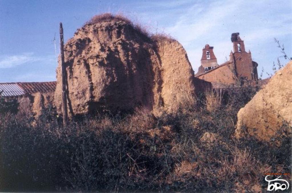
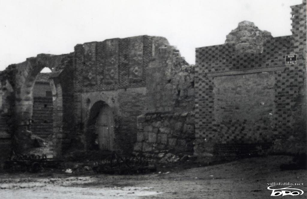
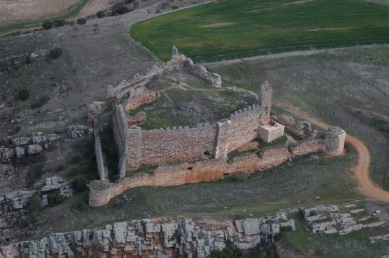
The fence was made of mud like most of the buildings in the town and in 1494 it was deteriorated and broken to give way to the streets that led to the fence: “We visited the said town and its walls, which are made of dead earth and very battered and chipped” , in such a way that three years later, 1497, Commander Alonso de Esquivel, when investigating the neighborhood and assets of the Order of Santiago in Villafáfila: “ I did not think it would be fair to order the appraisal of the fence that the said town has, and the aforementioned teachers who wanted to appraise it, since it was all almost on the ground ”; and in the year 1499, by order of the Catholic Monarchs, it was repaired: “The walls of the town are made of earth and they are all hatched, now the council began to make a high wall in the gates” [15] . It ran parallel to the current streets of El Rosario, La Botica, El Sacramento and El Triunfo, forming a square of about 200 meters on each side, including an area of approximately 4 hectares in its enclosure. The length and layout of the fence can be determined by observing the current urban layout (possible remains still persist in the SE corner), and from documentary references from later times. In 1542, when the town was taken over to be transferred to the Marquis of Távara, the residents were prohibited from making silos in the fence [16] . Starting in 1555, he began a series of sales outside the portions of the fence to the residents of Villafáfila with whose houses or corrals they border. The lengths of these pieces are variable but the width seems to have occupied about 15 feet. But in some parts the wall of the fence remained. In 1707, regarding a lawsuit over some houses, it is mentioned that these: “...they face the church of San Martín and on the part of the corrals...with the fence of the said town...” parallel “...to the street that goes from Zamora to León and towards the houses and San Marcos lagoon...” (Current street of El Rosario); In addition, we are given news of his remains "... he saw many mounds of earth... it was a round or service alley of the houses of that neighborhood... although some tall mounds were recognized..." [17] . In the Cadastre of 1751, with regard to the delimitation of different houses, "the fence" "the street of the fence", "the fence of the Marquis " is mentioned several times, and in one of them it is more precisely said that it limits “...to the north with the fence, at noon with the street that goes from San Juan to San Salvador and to the east with the street that goes down from San Martín...” [18] .
In the NW corner of the fenced enclosure stood the fortress or castle, whose place name still survives, together with two thick rammed earth walls incorporated into the current farmhouse. The first references to the castle are indirect: Thus, since 1156, the successive tenants of the town are cited: “Comite domno Poncio tenente Uillam Fafilam ” [19] , a position that implies the existence of the fortress. In 1199, in the letter of earnest money to Dª Berenguela, among the tenures of the castles that the king reserves for himself due to their importance and that he does not give up to his wife so that the Castilians have them, Villafáfila appears [20] . In 1417 the castle is cited: “in the alcacer of the said billa and it is said that it is today in the power of the alcayde of the said alcacer ", being different from the commander's palace "that they could not take or take clothes or wood for the palace or for the alcacer" [21 ] . Already in the year 1494 it was in poor condition: “ the fortaleça is made of land and the town has some bastions that are very poorly treated ” [22] . In 1497 we are given news of its poor condition: “The said fortress, both high and low, and walls and tiles and wood...is so dissipated that very few walls remain upright...and that the house that is built on it...the warden who ordered it to be built he does not dare to drink in it nor is he more likely to hit the ground...” [23] . When the commander of Castrotorafe received the town in 1498, he carried out some small work on the castle so that its governor could live there: “ Which said fortress is all made of earth and has a high earthen wall and few defenses and likewise has a small dwelling, all poor thing says the commander who is not obliged to repair that state received it and even he has done something in the accommodation, their highnesses send in it to try what their services may be ” and still in 1501 the warden lived in the fortress: “ Is it all land and does it have few defenses according to your opinion and a house and certain bastions? knocked down except for one room where the warden is .” The state of it continued to deteriorate and in 1503: “ The said visitors visited the fortress of the town, which is all fallen and there are no defenses or buttresses in it, the walls of the said town are made of mud and are fallen, in the book of the last visitation it says that they heard information about what that it was demolished and in what time it was demolished and they gave the information to the mayordomo of the commander and for that reason they did not send anything and that their Highnesses send them to try it” [24] . The fortress collapsed around 1511: “ There was a strong house and a fortress of earth that fell down thirty years ago and now it is down ” [25] .
In 1751, among the assets of the Marquis of Távara, lord of the town, it is cited: “...the site where formerly there was a fortress castle, the one I heard is completely ruined with nothing left but a large promontory of land and some silos...” [26] . Its soils and the remains of its rammed earth were required by the Villafáfila saltpeter manufacturer in 1789, for use as drying racks and as extraction land, but the refusal of the Duke of Infantado, then lord of Villafáfila, gave rise to a lengthy lawsuit. Later, part of the land was sold as lots so that some of the neighbors whose houses were demolished to build the Royal Saltpeter Factory in 1796 could build their houses there. In the area of the castle there are remains of medieval ceramics corresponding to to the 12th - 13th centuries, which serve as archaeological confirmation of the written documentation. [27] . Within the primitive fenced nucleus there is a large open space that currently corresponds to the Plaza Mayor, where the palace of the commander mentioned in 1417 was. In 1494 the visitors of the Order of Santiago say: “We visited some parts of the house that the horde had, which is next to the plaza of this town and through information from men who saw a house made there and saw men from Pº de Ledesma in it and who had seen mules in said house of farming of the said commander and of his father who was also commander ” [28] . The quicksilver or place where the daily market was held must have been located in the square, which was almost always in the center of the towns, unlike the location of the weekly market or the fairs that used to be held outside the city walls. villas [29] , and possibly located at the end of what is now Calle de La Botica in the surroundings of the so-called Pozo de la Villa (because the memory of the annual fair of Santa Isabel still remains, and that was where the threshing machines were established and other craftsmen of wood and tools). The existence of quicksilver is known indirectly in the year 1310 where the bishop had rented some: “...houses on the Azogue, because they overlook longuer...” [30] .
Around the primitive old quarter, the urban fabric of the town was developed by apposition of neighborhoods grouped around the churches, which would merge into a single population, respecting the North-South road axis. The construction of the churches took place throughout the twelfth and thirteenth centuries until reaching the number of ten documented parishes, whose location can be made by the survival of several squares or streets with the names of those, and the persistence of the memory and oral tradition, since the last four have known this century. [31] Of the ten parishes, only one was located within the fenced enclosure, that of San Martín, which would possibly be the oldest, and in the fifteenth century at its collation it was known by the name of La Villa , which is well expressive of the situation of the primitive village. However, within the inner enclosure of the fence some other parishes outside the walls had parishioners, which may be due to the fact that with the real organization of the town, parishioners were assigned within the walls to the different churches that already existed or were emerging. [32] In addition to the more or less compact urban fabric of the town, we have news of the existence of suburbs , "and put markers and all those who from the markers inside face the said town and suburbs plant bread or every garden or a vineyard that closes it from a high wall” [33] , and of Puebla, which at the beginning of the 14th century was uninhabited , “...and a land that was Puebla...”. That was located north of Las Pilas. Likewise, another suburb was located to the east of the town around the hermitage of La Magdalena, mentioned in 1512, in whose territory a neighbor still lived in 1597. As in other towns in Tierra de Campos, within the urban area there were not only dwellings, but also haystacks, dovecotes, curtains, orchards, stables, warehouses, silos, etc..., with a diversification of urban land that contributed to its greater extension. The grouping of orchards in a given area has been known since 1143: “a vineyard in Uilla Fafila...in illos ortos”, in 1148 “una corte ad cimiterio sancte Marie” [34] , in 1165 “a house cum suo exido” [35] , in 1490 the house of Collantes had an orchard attached, with a dovecote and adjoined other orchards; On the outskirts of the town there would be larger orchards or josas like the one that the Moreruela monastery had: “...for the xosa that the monastery in the house does not kill them from now on career...” [36] ; the commander's orchard was also next to the town: “ we visit a garden that is together with the town ”. The medieval cellars were next to the houses and they were made of brick arches, like the one left by Yván de Collantes when he died in 1490: “ the winery inside the town with its winery, the cellar adjoining the heirs of Pº Rodríguez and the houses of Alonso Fernández and calle de cabe la cerca”. Some of the warehouses have persisted to the present day, such as those behind the well-known Casa-Palacio del Duque, which have collapsed at the beginning of Calle de Rejadarada, since they already appear on the boundaries of the house that Don Pedro Pimentel bought in 1475: “ in the San Martin collation in the square within the town, bordering the house of Juan de Villagómez and Alvaro de León winery and Juan de Valderas winery and public streets and council square ” ; the silos where the grain was stored were underground and were in the streets of the town and in the high areas, such as Santa María or El Corrillo, although they were privately owned.
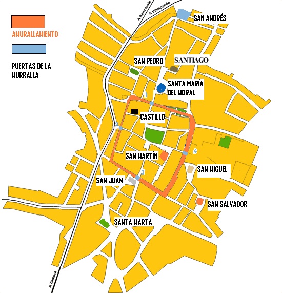
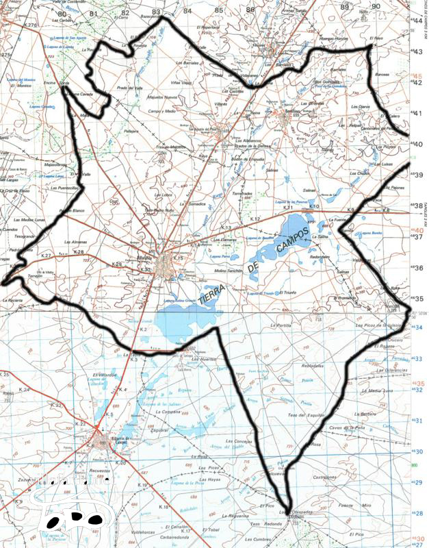
The extension of the urban area at this time can be calculated based on the location of the churches, since the urban fabric was framed around them. If we take into account that the distance between San Andrés and Santa Marta, which are located on the longitudinal axis, is 900 m. in a straight line, and that the distance from Santa María la Nueva to San Salvador, on the transverse axis, is 600 m. gives us an area of more than 50 hectares, which extended the town to the sown fields. Thus in 1417 the problem that derived from it is mentioned: “They said that in the said Villafafila no one had lived, that the lands together with the billa were moored, and the owners of said lands did not want to close them and pledged the cattle that entered such fields, from which they came to the said billa very great damage, for having nearby such loaves that ansy are together with the said town” [37] . In subsequent centuries, the urban area was reduced, especially in the suburbs of Santa María la Nueva and Santa Marta, until the 18th century, when the construction of the Royal Saltpeter Factory brought about the demolition of many houses and the rethinking of urban space. At that time it was common to find foundations on lots that were destined for curtains or wastelands on the outskirts of the town, an indication of the reduction of the hamlet at that time: "Well, according to reports we have and according to what we have experienced in various excavations that have been made, where several foundations have been found, this place could have been all inhabited in ancient times" [38] . The alfoz of Villafáfila The word alfoz serves to name the territory over which the town exercised its jurisdiction; Within that contour there were several dependent villages of that one. The delimitation of the alfoces could be done by the king at the time of the foundation of the towns, or in successive interventions subjecting it to extensions or reductions during the twelfth and thirteenth centuries. The alfoz of Villafáfila was delimited by that of Castrotorafe, whose limits were set by Alfonso VII in 1129, by that of Benavente, established between 1167 and 1181, by the town of Vidayanes of the Order of San Juan, by that of Villalobos to which the village of Villanueva la Seca, which bordered on the term of Revellinos to the north, by that of Villalpando, by that of Salinas, Otero and Muélledes. Sometimes there is a correspondence between the old territories of the 10th and 11th centuries, and the new alfoces of the towns. In the case that concerns us, the Villafáfila is smaller than the old Lampreana and its reduction must have been produced by donations of land and villages by the kings with the consequent immunity.
In addition to the royal actions of concessions of land and towns to different monasteries made in the area by Alfonso VII, the infanta Sancha and Fernando II between 1152 and 1170 mentioned above, which involved a territorial reorganization of the area, other similar processes must have taken place between 1181, when Fernando II made a donation of Villafáfila to the Order of Santiago so that they could establish their main house (a donation that had no effect due to the non-compliance of the conditions by the Order of Santiago) and the definitive delivery of the town and its alfoz to that militia in 1229 by Alfonso IX. This is how Otero de Sariegos must have been excluded, since in 1178 it belonged to the alfoz: “hereditary qua habet in Otero de Serigo....iacet supranominata uilla in alfoz de Villa Fafila...” [39] , but in the fourteenth century it already belonged to D. Arnao de Solier, Lord of Villalpando. Before his death, Alfonso IX donated the town of Villarrín to his granddaughter, the queen of Portugal, Dª Mencía, who in 1257 sold it to the nuns' abbey of Cañas, in La Rioja, in a deed made in Villafáfila [40] , and At some point during that time, the monastery of Santa María de la Puente received the village of Fortiñuela. With the definitive establishment of the lordship of the Order of Santiago over Villafáfila and its villages from 1229 and its transformation into an encomienda of said militia, the alfoz had to be definitively fixed and delimited by milestones and landmarks that were renewed periodically to avoid conflicts. with neighboring towns and villages. This is how they were in 1418: “...and they say that having their terms and pastures in which their cattle and oxen and beasts roam marked out and designated among them and the council and officials and good omes of Benabente and having their cattle and beasts there and using their terms as they always used and got used to...”. [41] .
Even so, we are aware of the boundary problems with the Moreruela monastery around the La Tabla mountain. These arise as a result of the exchange made by the monasteries of Sahagún and Moreruela of the estates of Montenegro and Muélledes in 1254. The council of Villafáfila argued that in these mountains they had the right to graze and cut firewood, which the new owners refused. This led to an arbitration of three judges, Fernán Fernández, mayor of the king, Minaya de Zamora and Martín García, commander of Castrotorafe in 1256, who established the limits to the rights of grazing and cutting in the aforementioned mountains, among the races that came together in the Pedrón that marked the boundary of the monastery and they went to Villafáfila and to Bretó, and from these races against Villafáfila [42] . Likewise, between the residents of Benavente and its villages, especially Santovenia and Valle, and those of Villafáfila and theirs, there were differences due to the use of pastures in spaces such as "El Prado del Valle" and due to the exploitation of firewood mountains, which had to be resolved through the appointment of two special judges, one by the maestre de Santiago as lord of Villafáfila and another by the count of Benavente, as lord of said town, who sentenced in a public hearing held in the Pedrón Blanco, in the line between Villafáfila and Valle [43] . With other neighboring towns we know later or indirect references, but that will surely have their origin in the Middle Ages. Thus we know of the existence of a Recierta or term in dispute between Villafáfila and Muélledes before 1525 [44] , which gave rise to a lengthy lawsuit in Chancillería in the 16th century. Among the indirect ones, I believe that the denomination of a payment of Villárdiga next to the Villafáfila line known as Las Differences indicates the existence of differences in the delimitation, in an area close to where the village of San Isidro should have been located. The extension of the alfoz would be about 12,000 hectares, basically occupying the current municipal districts of Villafáfila, Revellinos and San Agustín del Pozo, although within it there could be some territory exempt from jurisdiction, such as Fortiñuela, which belonged to the canons of Benevívere, or the village of Salinas that in the fifteenth century belonged to D. Pedro de Ledesma, chief huntsman of King Henry II and commander of Castrotorafe and Villafáfila. We have indirect references to the villages that were part of the alfoz de Villafáfila, so to make the list I include those of which we have documentary evidence of their belonging to it, or that we know with certainty the location of their remains within the terms previously cited. Some of the oldest villages that we have references to from the 10th and 11th centuries are not mentioned again in subsequent documentation, as is the case of Coreses or Villa Travessa . Others are cited for the last time in the twelfth century, so we assume that there must have been a phenomenon of transfer of the inhabitants of some villages to the town in the period of organization of the same, as we know that it happened in other places on Earth. of Fields [45] . An example of the above can be the case of Terrones, a village known since 954, whose council and its priest donated the church of Santa María to the monastery of Eslonza in 1147, for which, presumably, they would become part of the collation of the parish in the new village [46], or the case of Oter de Frades, a village belonging to the Sahagún monastery, which was uninhabited in 1201, at the same time that this monastery owned the church of San Miguel in the town. It is also common to find sites whose material remains do not exceed the twelfth - thirteenth century. List of villages integrated in the alfoz de Villafáfila and year of their last date :
Depopulation of the region in the Late Middle Ages With the passing of the 13th century there was a process of disappearance of several populated nuclei or villages in the term of Villafáfila, as well as a decrease in the population of the town. About this we know that the church of Santiago must have disappeared during the 13th century, since it is cited for the last time in 1201, because it was located next to Santa María and both belonged to the monastery of Eslonza, to which it would be more profitable the concentration of all its parishioners in a single parish; Before the end of the 15th century, two other of the ten parishes had to disappear: Santa María la Nueva is cited for the last time in 1310 as a parish, and still in 1332 there was a priest in the church of San Miguel. In compliance with the will of Yván de Collantes, who died in 1490, the following are given: "100 mrs to nine churches of the town that mounts 900 mrs", but in 1494 only seven parish churches are cited in the town and two on the land: “and there are seven in the town and two in two villages that are San Agostin and Revellinos, which are nine churches” [47] . Santa María la Nueva remained a hermitage until the 17th century, San Miguel was annexed to the parish of San Salvador. In 1283 the estate of Pobladura is cited in Villafáfila, which would correspond to a small village [48] , and in 1310 the land in which Puebla was mentioned is mentioned , which indicates the existence of an unpopulated area before the demographic crisis of the second half of the fourteenth century. In the Late Middle Ages, the existence of numerous depopulated areas in the surroundings of Benavente, Villalpando and Zamora is mentioned [49] . Not available for the territory included in the diocese of Astorga from general data for the knowledge of uninhabited places, so the phenomenon of depopulation is deduced from indirect data, such as the last mention of a village and the fact that at the end of the 15th century only in the jurisdiction of Villafáfila the villages of Revellinos and San Agustín. The process of disappearance of villages in the terms of Villafáfila must have been continuous since the mid-twelfth century, with the difference that, until the end of the thirteenth century, the population of the villages moved to the town to integrate the different collations, and, From the 14th century, both the town and the different villages in its alfoz suffered an unfavorable demographic evolution, which must have gone hand in hand and be a consequence of the decrease in the production of the salt mines, in addition to negatively influencing the pestilences (we know of the presence of the Black Death in the region in 1348), the civil wars (especially the passage of the Anglo-Portuguese troops of the Duke of Lancaster in 1387) and nobility abuses that gave rise to the great general crisis of the kingdom in the second half of the century XIV [50] . The decrease in salt production is noted by the scarcity of documentary references of purchases, sales and rents of salt from the 13th century. I believe that it could be caused by a progressive depletion of the salt richness of the waters that would affect the profitability of the farms, with the consequent abandonment of many of them. In addition, three events that occurred in the 13th century could negatively affect the Villafáfila salt mines: - The political union of Castilla y León in 1230 meant an opening of the Leonese territories to the salt from the Castilian salt flats of Añana, Poza, Atienza, which until then had belonged to an enemy kingdom, with the consequent difficulty of movement. - The Andalusian and Murcian conquests of the reign of Ferdinand III led to the development of long-distance trade that would affect salt prices. - The increase in rainfall and general humidity and the temperature drop of one degree in the climate [51] must have had a negative impact on the salt extraction processes that required dry and hot periods for the evaporation of water from the paused . The general decline in the population caused numerous vassal lords to enact various exemptions and provisions to prevent residents from leaving their lands and attract other settlers, such as those granted to the town of Toro in 1301 by Queen Doña María: " Those who come and live from here onward, from the alcazars as well as from the towns of the Orders, and from any other place, to remove the meat from their breasts for ten years" ; or the tax exemption concessions granted by the infante Don Juan and his successors to his vassals of Castroverde [52] .
These actions in nearby regions, together with certain provisions of the Cortes de Valladolid of 1325 that allowed the vassals of the Military Orders to live in the king's towns and cities without losing their ancestral estates, with the only obligation to pay the rights foreros, had to favor the abandonment of residents of Villafáfila and region towards those towns. In order to attract settlers to their lands, the Order of Santiago ordered in 1310: " And those who come to populate the earth should be excused from the chest for ten years" [53] . The masters also attenuated the feudal burdens of their vassals to prevent the abandonment of their towns. Thus, when the master Don Vasco Rodríguez hands over the town and land of Villafáfila to Juan Alfonso de Benavides, he agrees to keep them populated and not to inflict abuses on his vassals: "Let's populate your vassals of the said places as much as we can and that we do not offend them nor let us raise more than the right breasts that they will give to you at your order" , and the master don Lorenzo Suharez gave a letter at the end of the 14th century so that the commanders of Villafáfila: “From now on, they would not take the said clothes and wood and the said inns for themselves and for their homes and for their beasts and did not inflict other grievances or wrongdoing on them...I have seen how by the Lord King of Aragon (Fernando de Antequera, that he was Master of Santiago before being elected king of the crown of Aragon in 1412) , that God suddenly paralyzed himself, it was provided by a letter in which he ordered that it was God's service and settlement of the earth that the said inns” [54] . It seems that in the second half of the fifteenth century there was an increase in the population in the towns of the Crown of Castile, which is evidenced by the clearing of new land for cultivation; in Villafáfila we have news of plowing at the end of the 15th century: “I knew Mr. Pedro Pimentel to be lord of it (he was until 1497) and his wife, Mrs. Inés, at which time the council of justice, regiment, and neighbors broke a big term in her that they call Baltamariz, who is council” [55] , but it did not mean the repopulation of the old depopulated areas, although in some of them there were attempts. We know from references of various testimonies of 1530 the process of depopulation of the village of Fortiñuela, between the town and San Agustín, the oldest, who remember from 1460 say: "He saw the town of Fortiñuela and met two neighbors who moved to Santa Elena when the said terminus was depopulated and there were some houses and a roofless church with a small canpana", "he does not remember seeing it as a town of fifty and five years to this part but he heard his father and his mother say that when they got married (before 1465) his mother's father lived in the said Fortiñuela”. In the last decades of the fifteenth century, some residual and intermittent population could remain, one of the 70-year-old witnesses says that: “ While this witness was a boy, he saw three houses in Fortiñuela and knew two neighbors who were there fleeing from the pestilence of Villafáfila and this witness was there with them fleeing from said pestilence and that there was a church there called San Pelayo ”. At the end of the 15th century there was an attempt to repopulate the place, probably under the auspices of the priors of Santa María de la Puente, to whom it belonged: “This witness never saw Fortiñuela populated but he remembers that he wanted to populate it again and that he saw that in it they began to build houses and some people lived there, that this was at the time the Jews left and that later this witness he saw that it was depopulated again, he does not know how or why ”. It seems that these late settlers could be residents of San Agustín, to whom the priors had leased the terms for their cultivation, since in 1537 it is declared: “At the foot of fifty years (1490) this witness saw that certain people from the place of San Agostin who leased said area to the prior built certain houses to live in them and later they beat the said houses and this witness saw them beaten and knocked down." The fact is that the permanence of the village was not achieved, leaving its church for a time as a mute witness of a past settlement. We do not have numerical population data until the year 1497 when, by investigating the residents and income of Villafáfila and its land, we find 270 residents in the town, 69 residents in San Agustín and 59 in Revellinos [56] . At the end of the fifteenth century in the old territory of Lampreana we find: - with the town of Villafáfila belonging to the Military Order of Santiago reduced to seven parishes and in its alfoz with only two inhabited villages, Revellinos and San Agustín, and a series of hermitages and remains of churches of the depopulated (La Magdalena, Nuestra Señora de Villarigo, San Isidro, the Tower of San Pedro del Yermo, La Torrica de San Clemente de Valorio, the Tower of Sobradillo, in Villafáfila and the hermitage of San Sené and San Abdón in Revellinos). - the town of Villarrín, whose lord was the Marquis of Astorga [57] , which had been integrating in its terms the depopulated villages of Falornia, Santo Tirso or Muélledes and which also kept their churches as hermitages - the town of Otero de Sariegos belonging to the Constable of Castile - the place of Salinas including the old village of San Feliz, which belonged to D. Pedro de Ledesma and would be depopulated in the 16th century. - The pastures-uninhabited areas of San Pedro de Muélledes with its hermitage, the terminus of Oterino and that of Gamonal, and the uninhabited areas of Santa Marina de Moscas, with a church still in 1501 and San Sadornín, dependent on the encomienda of Castrotorafe - the meadow of Fortiñuela with a farmhouse belonging to the Priorato de la Puente - The depopulated Bamba that was integrated into the terms of Tapioles. Author Text: Elijah Rodriguez Rodriguez. History of salt mines in the Villafáfila lagoons. P. 53 to 62. Zamora: Institute of Zamoran Studies "Florián de Ocampo", 2000. ISBN 84-86873-87-8.
Photographs: Elijah Rodriguez Rodriguez. Jose Luis Dominguez Martinez. redlistheritage.org.
Transcription and montage: Jose Luis Dominguez Martinez.
All text, photographs, transcription and montage, their rights belong to their authors, any type of use is prohibited without authorization. All text and photography has been authorized for storage, treatment, work, transcription and assembly to José Luis Domínguez Martínez, its dissemination on villafafila.net, and any other authorized means. [1] Villar Garcia, 1991: 109. [2] Alfonso, 1991: 139. [3] Gonzalez, 1943: 40. [4] Serrano, 1928: doc.59. [5] Vignau, 1885: doc. XCVI. [6] González, 1943. Doc. 42. [7] ALVAREZ, L. 1995. Doc. 119. [8] Vignau, 1885: doc. XIV. [9] González, 1944: doc. 597. [10] Vignau, 1885, doc. XIV and LXXVIII. [11] Serrano, 1927: doc. No. 59. [12] Serrano, 1927 doc. No. 59. [13] A.CH.V. Civil Lawsuits. Perez Alonso. F. C.515-01. [14] Flatter. Saint Mark. [15] OOMM Lib.1090 and 1091. [16] AGSC and J. de Hª leg 14 - 1. [17] ADA Processes I Leg. 2305-16. [18] AHPZa. Cadastre leg.1628. [19] Rodríguez González, 1966: doc. 31. [20] González, 1944: doc. 135. [21] A.CH.V. Perez Alonso f. c.515-1. [22] OOMM Lib.1091. [23] Various AGS of Castile, Leg.41. Doc 42. [24] OO.MM. Lib.1093 and 1094. [25] Osuna Leg. 2152/17-2. [26] AHPZa., Ensenada, leg.1628. [27] Rodríguez, Larrén and García, 1991. [28] OOMM Lib.1090. [29] Martinez Sopea, 1985. [30] Flórez, España Sagrada, volume XVI, pp. 505-509. [31] The earliest documentary citations of the churches are as follows: -Santa Maria 1147 (Vignau. 1885: doc.78). -Santiago 1155 (Vignau, 1885: doc. 14). -San Martín 1162 (Quintano Prieto, 1987: doc. 682). -San Juan in 1165 (Serrano, 1927: doc.59). -San Pedro 1182 (Alfonso Antón. 1986: doc. 23). -San Miguel 1201 (Fernández Flórez, 1993 doc. 1544). -Santa María la Nueva 1307 (ADA Particulares nº 565). -San Andrés, Santa Marta and San Salvador in 1310 (Flórez, 1742. España Sagrada Volume XVI: 510). As for their location, those of Santa María and San Martín have persisted to the present day, those of San Pedro, San Salvador, San Juan and San Miguel in the squares of the same name, that of San Andrés in the old cemetery, that of Santa Marta at the end of the street of the same name, that of Santiago in the Plazuela del Crucifijo, behind Santa María, and, finally, that of Santa María la Nueva in the suburb (ADACódices, 3-3-15 bis ), near Las Pilas. [32] For the delimitation of the collations of the parishes, which usually remain throughout the centuries, I have collated data from the Civil Registry, neighborhoods, padrones and parish records. [33] A.CH.V. Perez Alonso f. c.515-1. [34] Vignau, 1885. [35] Serrano, 1927. [36] AHPZa. Disentailment. Box 235. [37] A.CH.V. Perez Alonso f. c.515-1. [38] DGR II. Leg. 2022. [39] ADLe. Gradefes, Doc. 131. [40] Gonzalez, 1980: 138. [41] A.CH.V. Perez Alonso f. 516 - 1. [42] AHPZa. Disentailment. Box 235. [43] A.CH.VPC Pérez Alonso (f) 516 - 1. [44] AM Benavente leg. 105. [45] Martinez Sopena, 1985. [46] VIGNAU V 1882. [47] AHN OO MM 1090. [48] AHN Military Orders. Uclés Folder 88 nº 27. [49] Lawrence Cow, 1995. [50] Farm. nineteen ninety six. [51] Vaca Lorenzo, 1995: 468. [52] Vaca Lorenzo, 1995: 472. [53] Santiago bulary. Cited by Granja, 1996: 81. [54] A.CH.V. Perez Alonso f. 516 - 1. [55] ARCH.V. Civil Lawsuits Pérez Alonso 127 - 4. [56] Various AGS of Castile 453. [57] Trancón, 1990: .27.
|
||||||||||||||||||||||||