THE BRONZE OF SOURCES OF ROPEL

|
THE BRONZE OF SOURCES OF ROPEL |
|
|
|
|
|
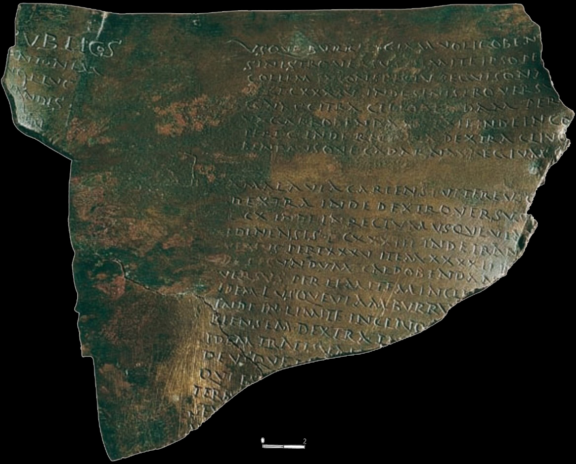
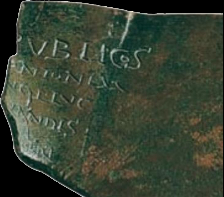
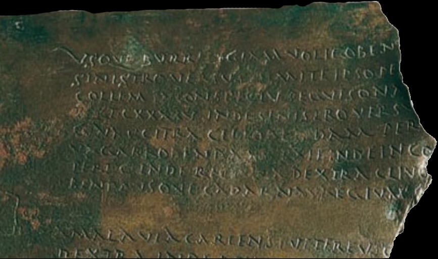
One of the most important documents from the point of view of the toponymy of Hispania has gone relatively unnoticed despite having been the subject of various publications [1] . Defined as litigatio-delimitatio , the bronze from Fuentes de Ropel, found in this town in the province of Zamora and preserved in the Museum of the capital (inv. no. 87120/1), seems to contain the termination of a territory. This considerable fragment of a bronze tabula includes a whole series of topographical precisions with indications of distances in perticae [2] and constitutes the densest repertoire of ancient microtoponymy from Roman times that we know of in the Iberian Peninsula (plates I-II). Its interest is increased by the fact that said toponymy, of a clearly indigenous nature, has been perfectly preserved in Roman times and -although extrapolations always have a gratuitous component- represents, in our opinion, a good indication of what could have happened in a significant part of Roman Hispania, even until very advanced times. If this were so, there is no doubt that the document we present would constitute a substantial contribution to discovering the permanence of the indigenous substratum in the topinaria, even beyond the moment in which it ceases to be transparent in a generalized way in personal onomastics. The linguistic transcendence is unquestionable and its value would increase if we achieved topographical precision to locate toponyms from a reference point and would increase even more if we managed to reach a certain level of chronological approximation. In a first edition [3] two of us proposed that it contained a sentence of terminis , in the manner of the one issued by the proconsul Lucius Helvius Agrippa in Sardinia in the year 68 (CIL X, 7852, ILS 5947). We currently believe that, although the content is not comparable in its formulation, it is, very probably, in its meaning. A second parallel is found in CIL V, 7749 (ILS 5946), the famous Sententia Minuciorum , which dates from the year 110 BC and that undoubtedly seems to have in the descriptive part some common elements to the one that now concerns us. Before any type of consideration, we propose a new reading of this fragment of the bronze tabula, made on autopsy, tracing and photographic documentation of the piece. Dimensions: - height: 22 cm. - maximum width: 22.3 cm. Letter height: - column A, r. 1: 1 cm.; r. 2: 0.5cm. - column B: between 0.4 and 0.6 cm.; u r. 1: 0.7 cm.; Oh, R. 9: 0.8cm.; B, R. 9: 2cm. Variants: - cabbage, A, r. 3. NQ ( fortasse recte ); r. 5. PRI -cabbage. B, R. 3 SEGVISONAE; r. 7 RECTVM; r. 8 BEND; GADARNAVREGIVM; r. 9 VSO; r. 10 VERSVS [ ; r. 13 I[N ; r. 14 CAVLDOBENDAM; r. 19 TRA NISVM; r. 21 ES; r. 22 TERB Our comment will deal with a series of aspects that we consider essential to be able to specify the content of the preserved document [4] .
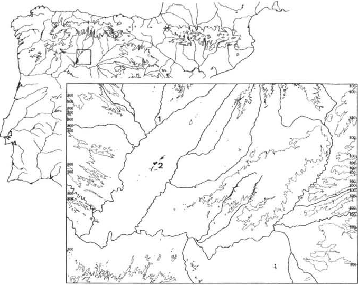
Paleographically, the inscription does not present problems since it is written in a capital of an almost bookish character in the first line of the title of column A. The rest corresponds to a careful capital with marked footnotes and usual strokes, especially in the AA and in the layout of M and N. The letter G lacks a crossbar. It should be noted in column B, line 9, the B conventionally called panse a droite , typical of the usual writing, forming part of the preposition ab , in a clearly prominent position compared to the rest of the text. In this same column, the first capital of line 1 is larger, elegant and wide, to surely indicate the beginning of the paragraph. The content of the text can be determined by two elements: one of context, the place of the find, and the second, internal, the beginning of line 5, CYNAS, returnable as [LA] CYNAS. Unfortunately, the finding of this bronze piece did not take place within a documented "archaeological" context, and we assume its appearance was related to clandestine activities, given that its recovery derives from an act of seizure. Consequently, the information on its discovery must be taken with the caution that this type of action proposes. Even so, its location in Fuentes de Ropel, a small town that has an extensive site located in the "Dehesa de Morales", between the Esla and Cea rivers, offers signs of certainty, in which a settlement of the Celtiberian period, romanized in early times, judging by the testimonies of their material culture [5] . Its urban character seems to be suggested by the exhumed construction remains (corresponding to domestic dependencies) and it has been identified with the supposed city of Brigaecium [6] , a municipality confirmed thanks to the existence of a duoviro, L(ucius) Fabius Silo, Brigiaecinust [7] . In a relatively close area (about 15 or 20 km in a straight line, in a southerly direction), in the heart of Tierra de Campos, there is a spot -now converted into a nature reserve- known as "Lagunas de Villafáfila [8] ". It is an area of gentle relief that presents large flooded areas, especially in winter, in which, at present, three well-defined lagoons stand out (Laguna de Barillos, Salina Grande and Laguna de Salinas, this last decade in the years 70), although in its surroundings there are -and there could have been some in past times- abundant small lagoons that we will not stop to enumerate [9](fig. I). Its current name is indicating a characteristic - its saline character - that possibly caused the area to become a focus of attraction for human settlements since ancient times. Indeed, in its surroundings there are abundant deposits since prehistoric times [10] , and some materials found - strainers and certain ceramic fragments - seem to indicate the interest in the use of salt. The excavations carried out at the Samtioste site, in Otero de Sariegos [11] reveal the interest in the exploitation of this resource and the detailed analysis of its The archaeological record shows, in the opinion of its researchers, the existence of an organized process to obtain the production of salt and its possible commercial distribution at the beginning of the Bronze Age [12].». The attractiveness of the area for the installation of habitation nuclei is demonstrated by the sequence of a settlement that is identified in the same or in different places, at different times (often some site betrays continuity or recurrence), and the occupation of this area in Roman times, judging by the material findings, is notorious: "Fuente de San Pedro", "Valorio", "Pocico de la Vega", "Tierras de Barillos", "La Cantera", "EI Escambrón", " La Mata" in the municipality of Villafáfila, "Los Villares-Neira" and "Raya de Villafáfila" in San Agustín del Pozo, "Las Tejicas" and "Fuentesalinas" in Revellinos, "Iglesia" and "Las Negras" in Otero de Sariegos, "Santo Tirso", "Pozuelos" , "San Pedro" and "Villardón", in Villarrín, and "Bamba" in Tapioles, limiting ourselves only to the area of the lagoons. The Visigoth period is also represented by expressive finds[13] .
From then on, Villafáfila knew a frenetic activity of salt exploitation until the s. XVII [14] . Returning to our document, it should be noted that the most interesting plugs in the area are: Coreses, Madornil, San Clemente de Fortiñuela, San Pedro de Otero, Sobradillo and Villarigo [15] . It is difficult to escape the Roman resonance of some names from Villafáfila's environment. The name of Barillos referring to one of the lagoons does not seem far from Burriligia , cited in the document, but it is an assumption. To the East, not far from here, there was an unpopulated area called Coria (Cauria), mentioned in the documents from 1140, as well as a "cauriense mount" (cited in the year 1013). It has been tried to interpret it as a population that came from Coria (Cáceres) but, in light of the discovery of Fuentes de Ropel, it must be related rather to an ancient Roman population of the same name [16] . We propose, as a consequence of the above, to propose the hypothesis that we are facing the delimitation of some salt flats that would probably be ager publicus or a conductio ceded to someone. The document that concerns us would deal with this fact and in column A, just as we have restored the text, it would contain the title and very possibly a date or the mention of the magistrates, before whom -or by whom- it is brought to carry out the legal action of limitation. The restoration of this column that we propose below is completely hypothetical but takes into account the number of letters calculated for the first line in the case of column B, more complete -between 39 and 41 letter spaces-, and in the dimension top of the letters of the first line: [LIMITATIO INTER AGROS] PUBLIC [ET -circ.26- FR]ONTONEM The term limitatio (delimitatio in Grom., 227,13) is documented, for example, in Siculus Flaccun [17] , while definitio is even more frequent and could also be another technical term, With regard to possible justices in r. 3, it is evident, as far as we know, that they do not seem to be consuls, since we do not find a pair that coincides with the conserved elements of both names. We should think, then, of a different element from that of a consular dating, surely those by whom or before whom the referenced legal act is carried out. The character whose properties are affected by this limitation undoubtedly bears the cognomen Fronto , very common among Roman citizens [18] , but documented in Hispania also among indigenous people [19] , probably because of his Celtic roots. We cannot specify the status of this character or whether he acts on his own behalf or on behalf of a community, the latter hypothesis that must be weighed and taken into account. It is not clear in column B if what is limited are the agri publici or a possession or perhaps a conduct of this Frontón individual, as we have seen in the restitution of r. 2 of column A. In principle, we would lean towards the attribution in conductio de agri publici in the context of a distribution of territory. Said agri publici could surround the territory or plot of Frontón although it could also be a generic delimitation from them, used to define the limits of all private properties or, even, the conduits(state leases) adjoining. In any case, the small extension and the fact that a polygon is defined in which the determined land is included could suggest more in a delimitation of a private property or conduit within the agri publici than in a reserve of these in relation to a private When commenting on this possibility with E. Rodríguez Almeida, he confirmed our criteria and accepted that it was a question of some salt flats and that some lacunae were mentioned ( see Appendix ). with their hypotheses about it, which we included with its explanatory text as an appendix.
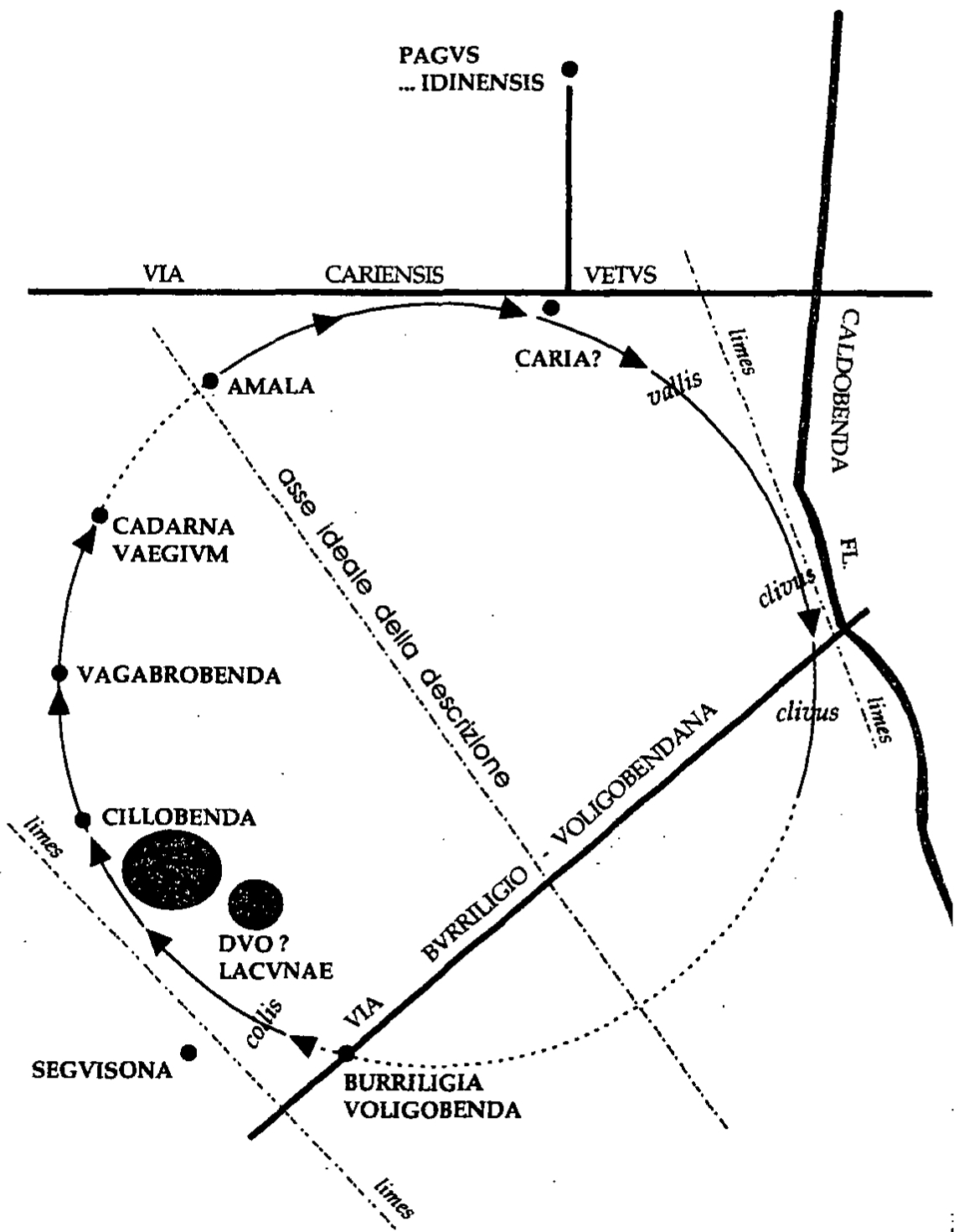
For our part, we would be in favor of a description according to the clockwise direction and we substantially agree that we have a specification that almost completes the perimeter -perhaps not circular, as the sketch by Rodríguez Almeida conventionally indicates- of the delimited agri . Let us remember here the technicality straightness . As far as toponymy is concerned, we are not going to expand on its origin and meaning either, which is undoubtedly Celtic in character. It will not be superfluous, however, to establish a list of the toponyms preserved in column B of the document: Burriligia, Burru voligobenda Seguisona/-benda(?) Cillobenda Vagabrobenda/-benta cadarnavaegium amala Via Cariensis Vetus Caldobenda Via Burruligiae/-endae Via Cariensis We have no difficulty, as we have indicated, with the affiliation of the names en- benda and for Seguisona , or perhaps Seguisonabenda , we are not without parallels either [20] . The Via Cariensis must be linked to other forms such as Carenses known in the peninsula [21] and the forms initiated by Burru - and Burri - are not unknown in the Peninsula either, even as anthroponyms [22] . Only a passing mention should be made of the geographical or better topographical description vocabulary used: limes , rectura, conspectus, perticae, clivus, via , which, together with direction indications [23] and distances, constitute the essence of the text , which has, due to the very descriptive structure of perimeter-traced limits, characteristics similar to those of an itinerary [24] . For the dating, it is necessary to focus fundamentally on the facies of the monument, since, as we anticipate, the possible magistrates present are not entirely clear. However, the first line of column A with the inclusion of O in COS together with paleographic aspects, seems to relate the text to bronzes such as the one from Monte Murado [25] , datable from the consuls indicated in 9 of, which would not fail to suit our text. Regarding the possible dating of the bronze in the Flavian period, it is necessary to say that the writing on this type of material is conservative and it is not necessarily necessary to take all the epigraphy on this support to the moment of greatest abundance in Hispania. In other words, the paleography is very similar and there is also no doubt about the paleographic kinship of the bronzes from the Augustan period with the very abundant Flavian epigraphy. In conclusion, the bronze from Fuentes de Ropel is an important limitatio agrorum document that takes on special importance based on its content. Its importance, if the proposed explanation and dating were accepted, would be very great since it would inform us about some salt pans, ager publicus par excellence, in Tierra de Campos, thus complementing the existing information on the subject in the Iberian Peninsula [26] . The salt pans would also gain importance in the interior lands and would perhaps help to better explain the substantial military implantation of control of the area, always linked to the exploitation of mines [27] . Beyond all this and any other interpretation or historical consideration of the list of toponyms that this document offers us, is the fact that it enriches what we know about the area and makes it a privileged model of Hispania's toponymic richness, probably intact under Roman domination, and that only documents like the one we are dealing with can contribute to revealing. APPENDIX EMILIO RODRIGUEZ ALMEIDA I have dealt with this piece, very incidentally and without the intention of going deeper than was necessary at the time, in the introductory chapter ("La tradizione cartográfico romana") of the forthcoming volume Formae urbis antiquae (Rome, BEFAR, 1998) , as one of the illuminating examples of Roman cadastral praxis and of the technical-legal rules that preside over and frame it. The substance of my observations now concentrates on two points: 1, the objective of this lex; 2, the diagram of the route. For the first, it is worth noting that the bronze document was certainly not intended to define a territory in general (municipal, colonial...) but rather a characteristic and peculiar sector of it, whether it be farmland, or (as with precise arguments is postulated in this study) of salt flats, a "strategic" asset of both the local community or communities and the "State" (I apologize for the neologism). The thing is evident from the fact that at two different points of the course we find the precision that exceeds ipso limit, per limitem(that is, the real border of the community territory, previously established). For the second point (path) it should be noted that this agro rum limitation develops from an ideal axis that divides the territory described, as shown by the adverbs "of movement" sinistroversus, dextroversus , clearly different from others of static function (such as in conspectu, citra, dextra ). From the point of view of onomastics, I believe that, in addition to the very important ( duo ?, tres...?) lacunae , the orographic precisions ( collis, vallis ) and roads are of notable importance: a via Cariensis vetus is certainly mentioned , which which assumes that another so-called nova must exist ; probably a branch of the track led to a pagus ...idinensis ; finally, it is possible that we speak of a Burriligio -Voligobendana road , from the name of the first town cited in the text; it is almost entirely true that the name Caldobenda , preceded by the adverb secundum("along) indicates a more or less large flumen or river. While we find localities, in one way or another linked to the territory, such as Burriligia (elsewhere perhaps spelled Burru -), Voligobenda , the lacu nae, Cillobenda, Vagabrobenda and Cadarnavaegium (or Cadarna Vaegium ); to the outside (perhaps even outside the true limits of the original territory) Seguisona seems to be found (of which the route passes in conspectu , "in sight of", "in front of"), the probable pagus...idinensis , which was reached, it seems, by a branch of the via Cariensis vetus and the Caria that gave its name to this road. As a last -but important- clarification, I would like to point out that the illustration of the route that we offer in fig. 2 is a simple indicative scheme . It is noteworthy, however, that since the old (more or less strictly cadastral) planimetrics that were at the base of documents like ours used to have South or Southeast high, it is possible that such a scheme had to be seen in perfectly inverted position, that is with high to low and right to left. In this way, on both sides of the axis of the inscription, there would be a perfectly canonical counterclockwise general course on ancient maps (the case, for example, of the regional arrangement in the Severian marble form of the city of Rome) and the axis of the description would constitute a kind of ideal cardo maximus of the limited area.
Authors: Marcos Mayer , José Antonio Abásolo Álvarez , R. García . Bulletin of the Seminary of Art and Archeology Studies: BSAA , ISSN 0210-9573, Volume 64, 1998 , pp. 161-174. https://dialnet.unirioja.es/descarga/articulo/67621.pdf.
Photography: Marcos Mayer , José Antonio Abásolo Álvarez , R. García .
Transcription and montage: Jose Luis Dominguez Martinez.
All text, photographs, transcription and montage, their rights belong to their authors, any type of use is prohibited without authorization.
All text and photography has been authorized for storage, treatment, work, transcription and assembly to José Luis Domínguez Martínez, its dissemination on villafafila.net, and any other means that is authorized. [1] We owe the news of its discovery to Dr. D. Miguel-Ángel Martin Montes. The first published news is from GARCÍA ROZAS, R., "Recovery of pieces. Archaeological interventions in the province of Zamora", AIZFO, 1987, p.67-70; see also the first edition of the text by GARCÍA ROZAS, R., ABASOLO, JA, "Roman Bronzes from the Museum of Zamora", Bronzes and Roman Religion. Proceedings of the XI International Congress of ancient bronzes (Madrid 1990), J. Arce, E. Burkhalter eds., Madrid, 1993, p.171-196, with appendix of ROVIRA, S., "Laboratory study of the Roman bronzes of the Zamora Museum", p. 179-181. Its file was published in the Astures Exhibition. Peoples and cultures on the border of the Roman Empire, Gijón, 1995 (ABÁSOLO, IA, "Delimitatio de Fuentes de Ropel" , p. 265). It also appears in the Catalog of the Roman Bronzes in Spain Exhibition, Madrid 1990, p. 170, n° 15 (photograph) and in the Catalog of the Roman Hispania Exhibition . From the land of conquest to the province of Impero , J. Arce, S. Ensoli, E. La Rocca eds., Rome, 1997, p. 365, n" 112 (photograph); the file is signed by J(ose) C(arlos) S(aquete), who cites a work in press by E. Rodríguez Almeida, Fonnae urbis antiquae , chap. I, fig. 2 , dating it to the Flavian period Cf., also in this same work, the appendix by Rodríguez Almeida himself. [2] This unit of measure is equivalent to ten feet, cf. Cato, agr.: decempeda quae eadem pertica appellatur, habet pedes X. It shows us, even more, that it is the definition of a small territory. [3] cf. note 1. [4] The commentary of the lexicon escapes our claim, but we do not want to overlook the use of the technical term of surveying, referred to by the gromatics, straightness . Cf. Die Schriften der romischen Feldmesser.II, F. Blume, K. Lachmann, Th Mommsen, A. Rudorff eds., Berlin, 1852, index verborum, svp 510, asi Grom. 5.15; 11.30. It means direction in a straight line: non posse forma cuiusli bet agri sine limitum rectura subsistere.
[5] MARTIN VALLS, R., DELIBES, G., "Archaeological finds in the province of Zamora. II", BSAA, XL-XLI, 1975, p. 455-458; "Archaeological findings in the province of Zamora. III", BSAA, XLII, 1976, p. 417-420.
[6] CELIS, J.: "Notes for the study of the occupational sequence of 'La Dehesa de Morales', Fuentes de Ropel (Zamora)", I Congreso Historia Zamora , II, 1990, p. 467-495; MARTIN VALLS, R., DELIBES, G., "Archaeological findings in the province of Zamora. II", ob. cit., p. 455-458; "Archaeological findings in the province of Zamora. V", BSAA, XLIV, 1978, p. 328-337.
[7] CYL II, 6094; ILER, 1664; RIT, 275.
[8] The same toponym of Villafáfila evokes the Latin favilla, a clear allusion to the salt mine. Cf. ThIL, VI, Prior, svp 378-381, esp. 380 (IIB I); Pliny the Elder (nat. 31.90 ): salinarum sinceritas summam fecit suam differentiam quadam favilla salis, que levissima ex eo est et candidissima .
[9] RODRIGUEZ RODRIGUEZ. E.: "The medieval settlement of the surroundings of the Villafáfila lagoons". AIEZFO (in press).
[10] RODRIGUEZ. E., LARREN. H., GARCIA. R.: "Archaeological Chart of Villafáfila". AIEZFO. 1990. p. 33•76.
[11] I CAME. A., MARTIN. AM, RUBIO, P.: "Emergency excavation in "Santioste". Otero de Sariegos", AIEZFO. 1990. p. 89-104: I CAME. A., SALVADOR. M., CHURCHES. L., RUBIO, P, MARTÍN AM: "New data about the site of "Santioste", Otero de Sariegos (2nd excavation season)", AlEZFO, 1990, p. 175-190.
[12] DELIBES, G.: "Salt and headquarters. A reflection on the site of the Ancient Bronze of Santioste, in Villafáfila (Zamora)", Brigecio , 3, 1993, p. 33-46; DELIBES, G., VINE, A., SALVADOR, M., "Santioste, a salt factory from the early Bronze Age in Otero de Sariegos (Zamora)", Studia Archaeologica , ep (we thank the authors for consulting his manuscript).
[13] Visigoth ceramics in "Valorio": RODRIGUEZ, E., LARREN, H., GARCIA, R.: "Carta Arqueológica de Villafáfila", ob. cit., p. 65-67. In addition, there is the famous treasure of Villafáfila: FERNANDEZ GONZALEZ, JJ: "The Visigoth treasure of Villafáfila (Zamora)", Numantia, III, 1990, p. 195-208; LARREN, H., "Treasure of Villafáfila", Astures. Peoples and cultures on the border of the Roman Empire, Gijón, 1995, p. 297.
[14] We thank our good friend Elías Rodríguez, a great connoisseur of the area, intensely documented on the subject, for the summary of the data that is expressed below, which we literally transcribe from his synthesis. Materials from all these sites have been deposited by said researcher in the Zamora Museum. "During the Middle Ages, the region was one of the most active centers of the kingdom of León due to the exploitation of the Salinas. The production system consisted of extracting water from salty wells or lagoons, storing it in cisterns and later spreading it on the threshing floors of the pauses so that the heat of the sun would evaporate the water, leaving the salt to remain deposited on the surface where it was collected or grated, since in the late medieval documentation pauses or graters are mentioned indistinctly, being stored in the Cabañas, which is what the salt exploitation unit has been called since the 11th century. In addition to this process of natural evaporation, they proceeded to the forced evaporation of salt water by means of fire, for which they used large quantities of firewood, the need for which caused early deforestation in the region and was the cause of multiple conflicts with the Moreruela monastery over the use of their mountains. At the end of the 15th century they went to look for firewood in the land of Távara. In Las Cabañas they had a covered building, with an adjoining fenced-in threshing floor, a garbage dump where they threw the ashes, one or several fountains or They proceeded to the forced evaporation of salt water by means of fire, for which they used large amounts of firewood, the need for which caused the early deforestation of the region and was the cause of multiple conflicts with the monastery of Moreruela due to the use of its mountains. At the end of the 15th century they went to look for firewood in the land of Távara. In Las Cabañas they had a covered building, with an adjoining fenced-in threshing floor, a garbage dump where they threw the ashes, one or several fountains or They proceeded to the forced evaporation of salt water by means of fire, for which they used large amounts of firewood, the need for which caused the early deforestation of the region and was the cause of multiple conflicts with the monastery of Moreruela due to the use of its mountains. At the end of the 15th century they went to look for firewood in the land of Távara. In Las Cabañas they had a covered building, with an adjoining fenced-in threshing floor, a garbage dump where they threw the ashes, one or several fountains or"foyos" of salt water and various inns or ralladeros. With the salt obtained, the cities of León, Astorga, Zamora and the main monasteries of the kingdom were supplied (Sahagún, San Pedro de Eslonza, Castañeda, Moreruela, etc.) and the nearby ones of Santa Marta de la Puente, Nuestra Señora del Valle, who were owners of Cabins in Villafáfila. In the 15th century, the distribution area of the Villafáfila salt trade was the counties between the Valderaduey, the Duero and the Raya de Portugal. The existence of these pauses with wells, cisterns, threshing floors and "eiratos" has been documented since 917. In the first half of the 10th century, the existence of more than fifty owners is known. The region surrounding the Salinas was known at this time as Lampreana, possibly due to the abundance of freshwater lampreys in the lagoons. Around them a series of villages related to the exploitation and trade of salt arise. In the current terms of Revellinos, San Agustín del Pozo, Villafáfila, Otero de Sariegos, Villarrín de Campos and Tapioles we can locate thirty-three villages cited between 917 and 1310, which gives us an idea of the demographic density Towards the middle of the 12th century, the kings Alfonso VII, Fernando II and Alfonso IX organized, repopulated and gave charters and territory to the town of Villafáfila, becoming the central nucleus of the region with political, military and religious functions. At this time it came to have 9 parish churches, castle and walled fence, quicksilver or market..., becoming in 1229, by donation of Alfonso IX, a charge of the Military Order of Santiago. Las Salinas continue its production until the 16th century. In 1518, the salt lords of Villafáfila sent a petition to the King, complaining about the entry of salt from Portugal, with the consequent damage to their huts, and reported that there were 12 or 13 salt huts in the town. Towards the middle of that century they definitively abandoned due to lack of productivity. Between 1767 and 1776, as a result of the industrial impulse policy of the ministers of Carlos III, they tried to put it back into operation and drilled 108 wells in the surroundings of the lagoons to try to find the supposed salt mine, without getting it. As a consequence of those works, the necessary saltpeter for the manufacture of gunpowder began to be obtained, and in 1795 a Royal Saltpeter Factory was built in Villafáfila, which was active until the occupation of the French, in 1808. Later it was disentailed and at the beginning of this century it was used as a flour factory that is currently in a dilapidated state". Vine. likewise MINGUEZ, JM, Sahagún's Diplomatic Collection in the IX and X centuries, León, 1976, documents 36, 60, 62, 63; CARRERA DE LA RED, ME, Toponymy of the valleys of Cea, Valderaduey and Sequillo, ed. Lancia, Leon, 1988, p. 311-320.
[15] RODRÍGUEZ, E., LARREN, H., GARCÍA, R. "Archaeological Chart of Villafáfila", ob. cit., p. 46-49.74. 16 CARRERA DE LA RED, ME, Toponymy of the valleys of Cea, Valderaduey and Sequillo, ob. cit., p. 409, 744.
[16] CARRERA DE LA RED, MF, Toponymy of the valleys of Cea, Valderaduey and Sequillo , ob. cit., p. 409, 744.
[17] Siculi Flacci de condicionibus agrorum, Die Schriften der romischen Feldmesser . IF Blume, K. Lachmann, Th. Mommsen, A. Rudorff eds., Berlin, 1848, p. 154.
[18] On Fronto cf. KAJANTO, I., The Latin Cognomina , Helsinki, 1965, p. 236.
[19] For Hispania, cf. ABASCAL, JM, The personal names in the Latin inscriptions of Hispania, Murcia, 1994, p. 372-373. The closest ones are in Villalcampo: RAE, 827, 886, 889, 897. We must highlight the stela preserved in the Museum of Zamora, RAE 897, which bears the name of P. Carisius Fronto , obviously linked to the clientele of P. Carisius , the propraetor legacy documented in the numismatics of Merida (RIC 1-25) between the years 25 and 22 BC On the coins of the latter, cf. BURNETT, A., AMANDRY, M., RIPOLLES, PP, Roman Provincial Coinage. I: From the death of Caesar to the death of Vitellius (44 8C.-AD 69); Part I: Introduction and Catalog , London Paris, 1992, p. 69.
[20] However, we do not intend to do anything here other than an edition of the text, leaving the toponymic study to the specialists of the matter. In any case, the kinship with forms such as Segisama or Segisamo , or even Amaia or Amallobriga , all of them in relatively close areas, is something that is not hidden from us. Let us remember that Amaia is mentioned in the first plate of the Barro de Astorga itinerary; see DIEGO SANTOS, E, Roman inscriptions from the province of León , León 1986, p.253-254, n° 328a.
[21] TOVAR, A., Iberische Landeskunde. Part Two: The Tribes and Cities of Ancient Spain, 3 : Tarraconensis , Baden-Baden, 1989, p. 393 for Carae ; p. 394 for Caravi ; p. 399 for Carenses ; besides Carietes , p. 60-61.
[22] UNTERMANN, l., Elements of an anthroponymic atlas of ancient Hispania, Madrid, 1965, p. 155-156, map n° 66. For Reburrus , RUBIO ALIJA, l., "Spaniards through the canines of the Roman Empire (Epigraphic-onomastic studies around Reburrus and Reburrinus )", Cuadernos de Historia de España, 29-30, 1959, p. 5-124.
[23] On the expression rectura , documented in the Gromatics: Die Schriften der romischen Feld messer. II, ob. cit., sv, index, p. 510.
[24] ABOSÓLO, JA, "Some reflections on the investigation of Roman roads in Spain", San Benito Notebooks, 3 (Meetings on the Tagus. The territory and communications) , 1992, p. 81-82.
[25] COELHO FERREIRA DA SILVA, A., "As tesserae hospitals do Castro da Senhora da Soude ou Monte Murado", Pedroso, VN Gaia , p. 1-26; AE 1983,476.
[26] SCHULTEN, A., Iberische Landeskunde. Geographie des antiken Spanien , Baden-Baden, 1974 (28th ed.), p. 449-458. Let us remember, for information only, the importance given to the Cardona salt, cited by Aulus Gellius (2, 22, 29) on a testimony of Cato (cf. p. 451).
[27] BLAZQUEZ, 1.M., "The mining exploitations and the Romanization of Hispania", The Romanization in the West, 1.M. Blázquez, 1. Alvar eds., Madrid, 1996, p. 179-200, with previous bibliography. |